Coventry No. 5 / Babbelak / Bablake / Coventru / Coventrv
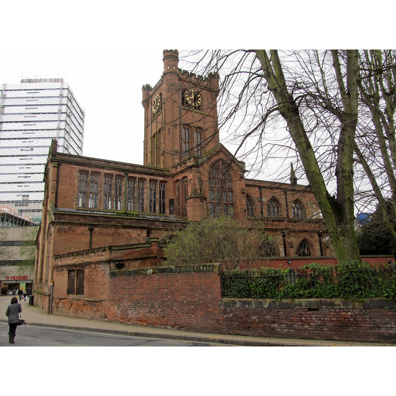
Image copyright © Ian Rob, 2014
CC-BY-SA-2.0
Results: 1 records
view of church exterior
Scene Description: Source caption: "Coventry-Saint John the Baptist Church. Looking from Hill Street."
Copyright Statement: Image copyright © Ian Rob, 2014
Image Source: digital photograph taken 6 April 2014 by Ian Rob [www.geograph.org.uk/photo/3919644] [accessed 9 March 2015
Copyright Instructions: CC-BY-SA-2.0
INFORMATION
Font ID: 19753BAB
Object Type: Baptismal Font1?
Font Century and Period/Style: 14th century (mid?), Decorated
Church / Chapel Name: Collegiate Church of St. John the Baptist
Church Patron Saint(s): St. John the Baptist
Church Notes: original church was 14thC gild chapel
Church Address: Hill Street, Coventry CV1 4AX
Site Location: Warwickshire, West Midlands, England, United Kingdom
Directions to Site: Located at the junction of Fleet Street and Hill Street, in the city centre
Ecclesiastic Region: Diocese of Coventry
Additional Comments: disappeared font? (the one from the mid-14thC church here)
Font Notes:
Click to view
The Victoria Country History (Warwick, vol. 8, 1969) notes: "The collegiate church of St. John Baptist, Coventry, owes its origin to one of the earliest trade gilds of the city. The gild of St. John Baptist was founded on 6 October, 1342. [...] On its first establishment, one of the objects for which it obtained its licence was the founding of a chantry for six priests to sing daily mass in the two great churches of St. Michael and Holy Trinity. But in 1344 the dowager Queen Isabel, who held for life the manor of Cheylesmore, granted to the gild of St. John a parcel of land called 'Babbelak,' 117 ft. long, and varying in breadth from 40 ft. to 33 ft., on which to build a chapel in honour of God and the Baptist, for their own services, but stipulating for a chantry of two priests to sing daily mass for the royal family. [...] The eastern portion of this chapel was ready for consecration on 2 May, 1350. [...] In 1392 the gild of the Holy Trinity was united to those of St. John Baptist and St. Mary, and under the joint name (though more usually styled Holy Trinity) had licence to purchase lands for the maintenance of nine priests to sing mass daily in the chapel of Bablake for the good estate of Richard II and his queen and his uncles. [...] The college was dissolved in 1548 and later that year the site and buildings were granted to the city. [...] The church itself was apparently dismantled and remained little used [...] until the early 17th century. The church was restored as a place of worship in 1608 [...] Two modern parishes have been created partly out of St. John's: St. Thomas, Albany Road, in 1844, and St. George, Barkers Butts Lane, in 1935." [NB; the other Coventry church dedicated to John the Baptist, on 27 Westwood Heath Road, Coventry CV4 8GN, is a mid-19thC building with a modern font].
COORDINATES
UTM: 30U 600924 5807456
Latitude & Longitude (Decimal): 52.408017, -1.516319
Latitude & Longitude (DMS): 52° 24′ 28.86″ N, 1° 30′ 58.75″ W
REFERENCES
- Victoria County History [online], University of London, 1993-. URL: https://www.british-history.ac.uk.