Oztoticpac
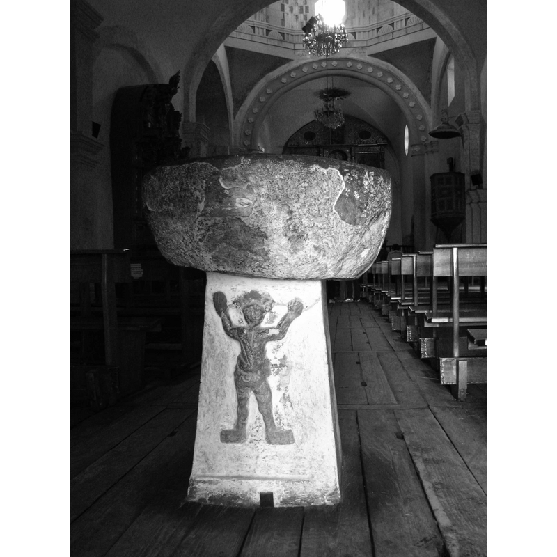
Image copyright © Cynthia Barrera, 2008
No known copyright restriction – Fair Dealing
Results: 3 records
view of font
Scene Description: Source caption: "LA PILA BAUTISMAL. Oztoticpac, Hidalgo MEXICO" [NB: where is it from?]
Copyright Statement: Image copyright © Cynthia Barrera, 2008
Image Source: digital photograph taken 30 August 2008 by Cynthia Barrera [www.flickr.com/photos/cucubianita/2832577244/in/photostream/] [accessed 7 March 2015]
Copyright Instructions: No known copyright restriction – Fair Dealing
information
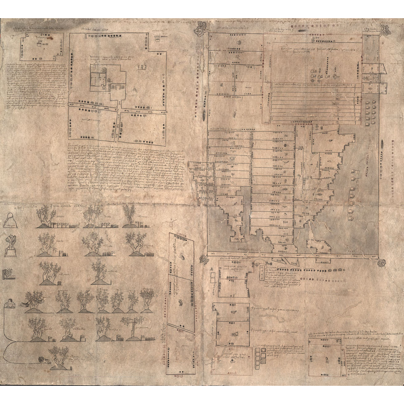
Scene Description: Source caption: "Dated at approximately 1540, this map, a Mexican pictorial document with writing in Spanish and Nahuatl, relates to a lawsuit concerning the estate of Don Carlos Ometochtli Chichimecatecotl, an Aztec lord and one of the many sons of Nezahualpilli, ruler of Texcoco. Don Carlos was charged with heresy and publicly executed by the Spanish authorities on November 30, 1539. Litigation began on December 31, 1540, when a man identified as Pedro de Vergara petitioned the Inquisition to return to him certain fruit trees taken from the property of Don Carlos that Vergara claimed were his under a contract that had been concluded with Don Carlos several years earlier. Other individuals contended that the lands occupied by Don Carlos did not belong to him personally but to the family—the lords of Texcoco—as a whole. This map most likely was commissioned by Antonio Pimentel Tlahuilotzin, governor of Texcoco, to buttress these claims. Further complicating the case were claims by another set of petitioners that the Texcocan lands had been partitioned by the Spanish authorities and that lands held by Don Carlos during his lifetime were now the property of commoners. The outcome of the litigation is not known. The map reflects the pre-European, Mesoamerican tradition of using glyphs and indigenously produced paper (amatl) to make maps. Drawings done with red and black inks indicate land plots with indigenous measurements and place glyphs. Near the upper left is a plan of several houses within a precinct; on the right are maps showing more than 75 identified plots, an inventory of landed properties once owned by Don Carlos. In the lower left is a gloss of European fruit trees and grape vines grafted onto indigenous tree stock, the only such image of this agricultural technique known to exist in any Mexican indigenous pictorial document. The map provides details about the grafting of peach, apricot, pear, and other fruit trees imported from Spain onto apple and cherry trees indigenous to Mexico."
Copyright Statement: Image copyright © [in the public domain]
Image Source: image of a 1540 map [source: Title derived from The Quarterly Journal of the Library of Congress, "The Oztoticpac Lands Map of Texcoco 1540," v. 23, no. 2, April 1966, pp. 76-116.] [http://commons.wikimedia.org/wiki/File:The_Oztoticpac_Lands_Map_WDL106.jpg] [accessed 7 March 2015]
Copyright Instructions: CC-PD-Mark
information
![baptismal scene showing Fray Francisco Lorenzo, founder of the first church at Oztoticpac, and later martyred in Etzatlan between 1541 and 1543 [source: Richard D. Perry (200) [www.colonial-mexico.com/West Mexico/West pix/etz pix/etz lorenzo.jpg] [accessed 7 March 2015]](/static-50478a99ec6f36a15d6234548c59f63da52304e5/compressed/0150307032_compressed.png)
Scene Description: baptismal scene showing Fray Francisco Lorenzo, founder of the first church at Oztoticpac, and later martyred in Etzatlan between 1541 and 1543 [source: Richard D. Perry (200) [www.colonial-mexico.com/West Mexico/West pix/etz pix/etz lorenzo.jpg] [accessed 7 March 2015]
Copyright Statement: Image copyright © [in the public domain]
Image Source: B&W illustration in Richar D. Perry (2006), supplied by Edward Fesler [www.colonial-mexico.com/West Mexico/West pix/etz pix/etz lorenzo.jpg] [accessed 7 March 2015]
Copyright Instructions: No known copyright restriction – Fair Dealing
INFORMATION
Font ID: 19746OZT
Object Type: Baptismal Font1?
Font Century and Period/Style: 16th century(mid?)
Church / Chapel Name: Iglesia de Santiago [disappeared]
Church Patron Saint(s): St. James
Church Notes: Oztoticpac appears in Manuel Orozco y Berra's 'Geografía de las lenguas y carta etnográfica de México' as one of six nahuatl-speaking 'estancias' of Tezayuhcan, in one instance, and of Texcaltitlan, in another; it was a tributary of the town of Tescuco. Mendieta's 'Historia eclesiástica indiana' (1770: 749-750) notes the foundation in the mid-16th century of a first church here, one dedicated to St. James, by Fray Francisco Lorenzo, a Franciscan originally from Granada, Spain
Church Address: [disappeared place -- no address or GIS information available]
Site Location: México, Mexico, North America
Directions to Site: disappeared location in the pre-Columbian province of Acolhuacan or Aculhuacan, eastern part of the Valle de Mexico
Ecclesiastic Region: Diócesis de Michoacan
Historical Region: Texcoco de Mora
Additional Comments: disappeared font? (the one from the mid-16thC church here)
Font Notes:
Click to view
[NB: we have no information on the font from the mid-16thC church here -- cf. Images Area]