Goltho
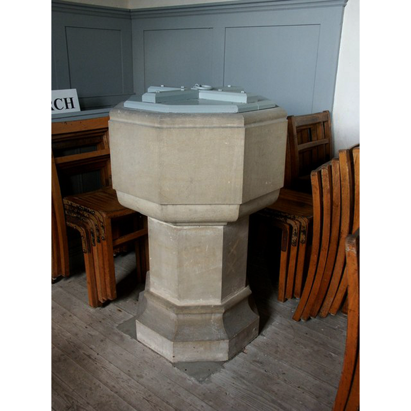
Image copyright © Dave Hitchborne, 2004
CC-BY-SA-2.0
Results: 6 records
view of font and cover
Scene Description: the modern font and cover of this church; they were probably destroyed in the 2013 fire [cf. FontNotes]
Copyright Statement: Image copyright © Dave Hitchborne, 2004
Image Source: digital photograph taken 21 May 2004 by Dave Hitchborne [www.geograph.org.uk/photo/434912] [accessed 1 March 2015]
Copyright Instructions: CC-BY-SA-2.0
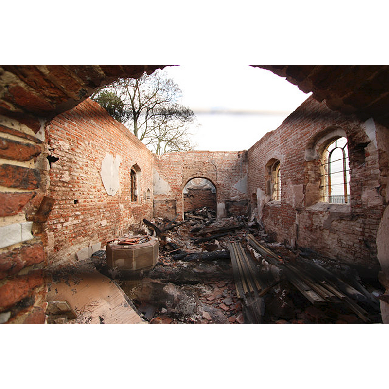
view of church exterior - southeast view
![Source caption: "St.George's church [...] five days after the disastrous fire of 21st October 2013."](/static-50478a99ec6f36a15d6234548c59f63da52304e5/compressed/1150301025_compressed.png)
Scene Description: Source caption: "St.George's church [...] five days after the disastrous fire of 21st October 2013."
Copyright Statement: Image copyright © Richard Croft, 2013
Image Source: digital photograph taken 26 October 2013 by Richard Croft [www.geograph.org.uk/photo/3716816] [accessed 1 March 2015]
Copyright Instructions: CC-BY-SA-2.0
view of church exterior in context
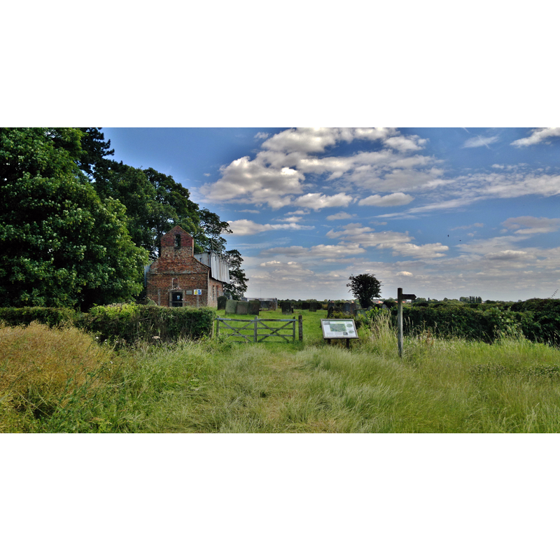
Scene Description: Source caption: "St George's church, Goltho. The ancient village of Goltho no longer exists, but this church was still in reasonably good condition until 2013 - when it may have been struck by lightning. The subsequent fire has left irreparable damage"
Copyright Statement: Image copyright © Chris Morgan, 2014
Image Source: digital photograph taken 14 July 2014 by Chris Morgan [www.geograph.org.uk/photo/4073601] [accessed 1 March 2015]
Copyright Instructions: CC-BY-SA-2.0
view of church exterior - southwest view
![the church in 2004 -- Source caption: "St George, Goltho. The church of St George is reached through a large field. [...] The site was inhabited for 900 years and the little church is all that is left. It stands on the site of substantial stone-built church. The nave is traditionally thought to have been built by the Grantham family when they purchased the estate in the 1530s, the chancel being added some 70 years later."](/static-50478a99ec6f36a15d6234548c59f63da52304e5/compressed/1150301021_compressed.png)
Scene Description: the church in 2004 -- Source caption: "St George, Goltho. The church of St George is reached through a large field. [...] The site was inhabited for 900 years and the little church is all that is left. It stands on the site of substantial stone-built church. The nave is traditionally thought to have been built by the Grantham family when they purchased the estate in the 1530s, the chancel being added some 70 years later."
Copyright Statement: Image copyright © Dave Hitchborne, 2004
Image Source: digital photograph taken 21 May 2004 by Dave Hitchborne [www.geograph.org.uk/photo/434903] [accessed 1 March 2015]
Copyright Instructions: CC-BY-SA-2.0
view of church interior - nave - looking east
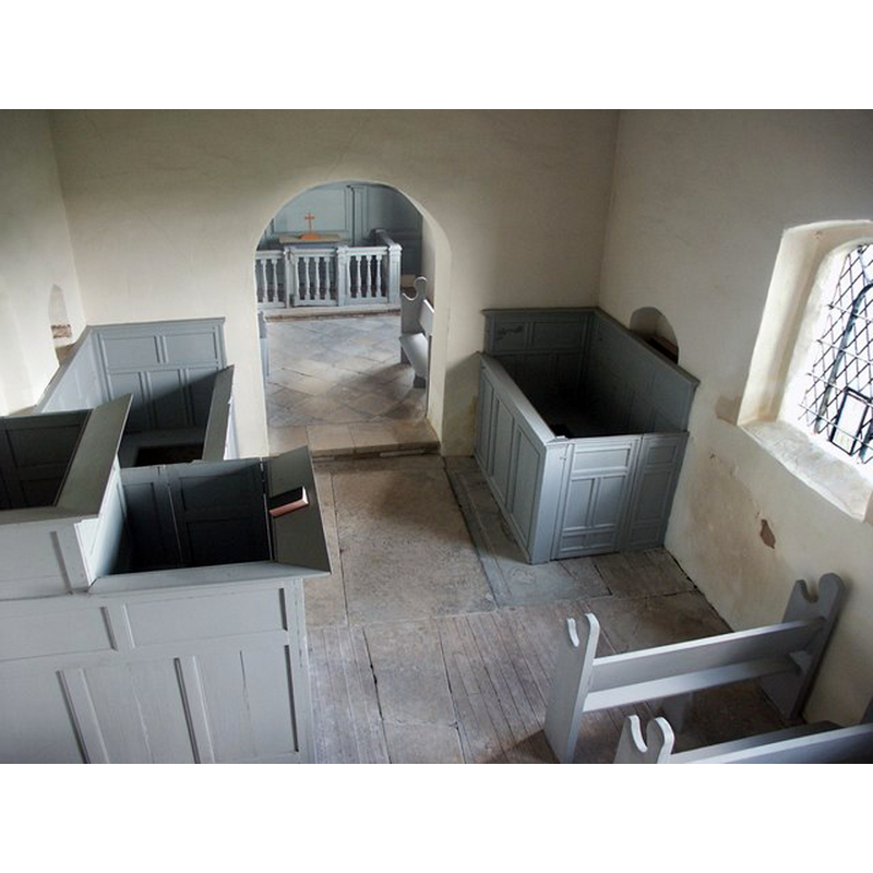
Copyright Statement: Image copyright © Dave Hitchborne, 2004
Image Source: digital photograph taken 21 May 2004 by Dave Hitchborne [www.geograph.org.uk/photo/434928] [accessed 1 March 2015]
Copyright Instructions: CC-BY-SA-2.0
view of church interior - nave - looking west
Scene Description: photograph taken five days after the 2013 fire -- Source caption: "St.George's church interior. Wide-angle view through security fencing to the burned out interior of St.George's church"
Copyright Statement: Image copyright © Richard Croft, 2013
Image Source: digital photograph taken 26 October 2013 by Richard Croft [www.geograph.org.uk/photo/3716903] [accessed 1 March 2015]
Copyright Instructions: CC-BY-SA-2.0
INFORMATION
Font ID: 19739GOL
Object Type: Baptismal Font1?
Font Century and Period/Style: 11th - 12th century / 17th century, Norman / Restoration?
Church / Chapel Name: Parish Church of St. George [redundant]
Church Patron Saint(s): St. George
Church Notes: church here originally Norman; present building 16thC; now redundant and in the care of the Churches Conservation Trust; badly damaged by fire in October 2013
Church Address: Goltho, Lincolnshire, England, LN8 5JD
Site Location: Lincolnshire, East Midlands, England, United Kingdom
Directions to Site: The church is all that remains of the medieval village of Goltho; it is located off (S) the A158, 3 km SW of Wragby, 18 km NE of Lincoln
Ecclesiastic Region: [Diocese of Lincoln]
Historical Region: Hundred of Wraggoe
Additional Comments: disappeared fonts? (one from the supposed Norman church ehere? another from the 17th-century church here [cf. FontNotes]
Font Notes:
Click to view
The Lincoln Echo of 21 October 2013 [www.lincolnshireecho.co.uk/Church-burnt-ground/story-19964665-detail/story.html#ixzz3T9pUnvlc] [accessed 1 March 2015] reported: "A disused church in Goltho, near Wragby, has been burnt to the ground following a fire in the early hours of this morning." Allen (1834) reports the church as "a small modern building" and mentions nothing of an earlier church here, as does White's 1856 History of Licolnshire and Wilson's Imperial Gazetteer of England and Wales of 1870-1872. Hannan-Briggs [2011?] [www.geograph.org.uk/photo/2543947] [accessed 1 March 2015] writes: "This is the site of the Deserted Medieval Village known as Goltho. Archaeological evidence shows this area was first occupied during the Roman period. People settled here again in the Anglo-Saxon period and by the 12th century a thriving village was firmly established, growing to 37 crofts occupied by mud and stud houses, with metalled roads, drainage ditches and a blacksmith’s shop. By the beginning of the 15th century, however, much of the site had been abandoned." Guy Beresford's 'Goltho: The development of an early medieval manor c 850-1150' in English Heritage (1987) gives an idea of the complexity and importance of early Goltho, where a church would have been expected, even though there is no entry for it in the Domesday survey, nor are there any obvious remains of it today.
COORDINATES
UTM: 30U 678180 5907063
Latitude & Longitude (Decimal): 53.2828, -0.3272
Latitude & Longitude (DMS): 53° 16′ 58.08″ N, 0° 19′ 37.92″ W
REFERENCES
- Beresford, Guy, Goltho: The development of an early medieval manor c 850-1150, 1987, [http://archaeologydataservice.ac.uk/archiveDS/archiveDownload?t=arch-1416-1/dissemination/pdf/9781848021563_all.pdf] [accessed 1 March 2015]