Polesworth
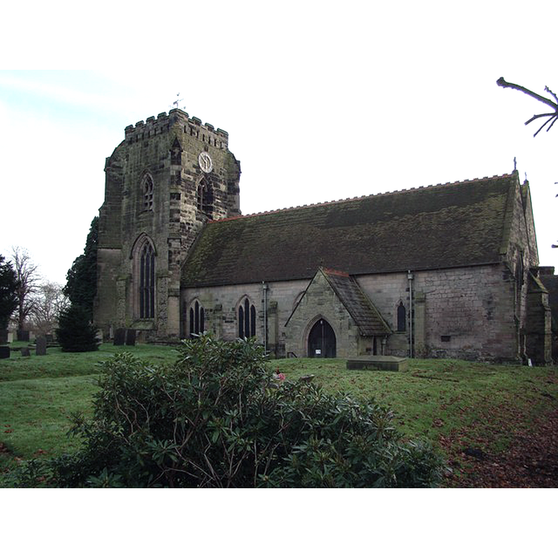
Image copyright © David Rogers, 2008
CC-BY-SA-2.0
Results: 2 records
view of church exterior - southeast view
Scene Description: Source caption: "The Abbey Church at Polesworth stands on the north bank of the River Anker."
Copyright Statement: Image copyright © David Rogers, 2008
Image Source: digital photograph taken 28 November 2008 by David Rogers [www.geograph.org.uk/photo/1063785] [accessed 10 December 2014]
Copyright Instructions: CC-BY-SA-2.0
design element - architectural - arcade - blind - trefoiled arches
![[cf. FontNotes]](/static-50478a99ec6f36a15d6234548c59f63da52304e5/others/image_not_available.jpg)
Scene Description: [cf. FontNotes]
![[cf. FontNotes]](/static-50478a99ec6f36a15d6234548c59f63da52304e5/bsi-testing-site/others/image_not_available.jpg)
INFORMATION
Font ID: 19566POL
Object Type: Baptismal Font1
Font Century and Period/Style: 14th - 15th century [basin only] [composite font], Medieval [composite]
Church / Chapel Name: Abbey Church of St Editha
Font Location in Church: Inside the church
Church Patron Saint(s): St. Editha [Eadgyth, Edgytha, Edith of Wilton, Ediva]
Church Notes: Abbey founded in 827, active continuously till 1549; abbey church became parish church after the Dissolution
Church Address: High Street, Polesworth, Warwickshire, B78 1DU
Site Location: Warwickshire, West Midlands, England, United Kingdom
Directions to Site: Located 5 km NW of Atherstone, 6 km from Tamworth, 10 km S of the Derbyshire border
Ecclesiastic Region: Diocese of Birmingham
Historical Region: Hundred of Coleshill -- Hundred of Hemlingford
Additional Comments: altered font? (the present one: 14th-15thC basin on a modern stem and lower base) -- disappeared font? the one from the original church [9thC? / 12thC?] here)
Font Notes:
Click to view
We found no entry for Polesworth in the Domesday survey. The Victoria County History (Warwick, vol. 4, 1947) notes: "The church of Polesworth was granted to the abbess and convent of Polesworth, with the manor, by Robert Marmion and his wife Millicent [Robert d. 1218] [...] The nave is of the first half of the 12th century and was probably always the part of the priory buildings that served the parishioners. [...] A 12th-century doorway which still survives just east of the present nave (and south of the modern chancel) would therefore have been the entrance from the north end of the western alley. [...] After the Suppression the whole of the abbey church, except for the doorway mentioned, disappeared. [...] The parish church that was retained suffered many vicissitudes afterwards [...] The font has a 15th-century octagonal bowl of which each side is treated with a trefoiled gabled panel with crockets and finial; the under edge is moulded. The stem and base are modern." English Heritage [Listing NGR: SK2633202433] (1968) reports a "C14 octagonal font has trefoiled blind arches and simple shafts" in this church.
COORDINATES
UTM: 30U 593950 5830773
Latitude & Longitude (Decimal): 52.618824, -1.612227
Latitude & Longitude (DMS): 52° 37′ 7.76″ N, 1° 36′ 44.02″ W
MEDIUM AND MEASUREMENTS
Material: stone
Font Shape: octagonal, mounted
Basin Interior Shape: rp
Basin Exterior Shape: octagonal
REFERENCES
- Victoria County History [online], University of London, 1993-. URL: https://www.british-history.ac.uk.