Atherstone-on-Stour / Edricestone
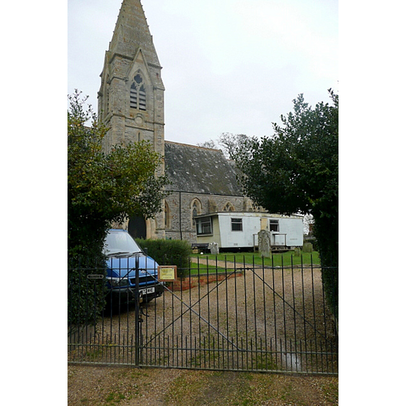
Image copyright © Graham Horn, 2013
CC-BY-SA-2.0
Results: 2 records
view of church exterior - southwest view
Scene Description: Source caption: "Atherstone church. This Victorian church has been decommissioned and is now a private residence. Work seems to have been going on for some time [...]"
Copyright Statement: Image copyright © Graham Horn, 2013
Image Source: digital photograph taken 12 January 2013 by Graham Horn [www.geograph.org.uk/photo/3307956] [accessed 8 December 2014]
Copyright Instructions: CC-BY-SA-2.0
view of church exterior - southwest view
![EXT S digital photograph taken by Aidan McRae Thomson [http://warwickshirechurches.weebly.com/atherstone-on-stour---st-mary.html] [accessed 8 December 2014]](/static-50478a99ec6f36a15d6234548c59f63da52304e5/compressed/1141209003_compressed.png)
Scene Description: EXT S digital photograph taken by Aidan McRae Thomson [http://warwickshirechurches.weebly.com/atherstone-on-stour---st-mary.html] [accessed 8 December 2014]
Copyright Statement: Image copyright © Aidan McRae Thomson, 2014
Image Source: digital photograph taken by Aidan McRae Thomson [http://warwickshirechurches.weebly.com/atherstone-on-stour---st-mary.html] [accessed 8 December 2014]
Copyright Instructions: Standing permission
INFORMATION
Font ID: 19555ATH
Object Type: Baptismal Font1, basin only
Font Century and Period/Style: 12th - 13th century, Medieval
Church / Chapel Name: Parish Church of St. Mary [redundant; now a private property]
Font Location in Church: [cf. FontNotes]
Church Patron Saint(s): St. Mary the Virgin
Church Notes: church redundant; sold as private property
Church Address: Atherstone on Stour, Warwickshire CV37 8NE
Site Location: Warwickshire, West Midlands, England, United Kingdom
Directions to Site: Located S of Stratford-upon-Avon
Historical Region: Hundred of Tremlowe [in Domesday]
Additional Comments: disused font? (the old basin [cf. FontNotes]) -- disappeared font? (the one from the Domesday-time church here)
Font Notes:
Click to view
There is an entry for this Atherstone[-on-Stour] [variant spelling] in the Domesday survey [http://domesdaymap.co.uk/place/SP2050/atherstone-on-stour/] [accessed 8 December 2014]; it reports a priest but not a church in it, though there probably was one there]. The Victoria County History (Warwick, vol. 5, 1949) notes: "The church was said in 1251 to have been given to the abbey of Tewkesbury by 'Roger' (probably Ralph) de Ruperes in the time of King John [i.e., 1199-1216] [...] The church [...] was rebuilt in 1876 [...] . A number of ancient stones were re-used, mostly dating from the beginning of the 14th century. [...] The font is modern, but in the south-west corner is an ancient plain round bowl with broken top surface and lower edges. In it is set another small octagonal bowl, probably early 19th century." English Heritage [Atherstone on Stour, Warwickshire CV37 8NE] (1972) reports: "Church, now disused. 1876, by J Cotton, incorporating material from demolished medieval church on site [...] octagonal C19 font with trefoil panels and plain round former font." Warwickshire Churches [http://warwickshirechurches.weebly.com/atherstone-on-stour---st-mary.html] [accessed 8 December 2014] has: "The former church of St Mary at Atherstone on Stour is an entirely Victorian creation, dating from 1876 and was designed by John Cotton, though there was a medieval church here, and a few pieces of it's stonework have been reused in the present building. [...] the interior, or even the churchyard are now out of bounds to the public. It has long ceased to function as a church and is now in private hands for commercial or residential use. I assume the stained glass and the old font must still be in situ. [...] The font is described as plain, tub-shaped and 'clamped to the exterior of the east wall', presumably this was the ancient font from the previous church put out to pasture? The Victorian church was provided with a new one in a more orthodox position in this case." The Parish web site [www.stmarysatherstone.co.uk/historylesson.htm] [accessed 8 December 2014] describes and illustrates the 19th-century font here: octagonal basin with the four Evangelists and four symbols of the Passion; on a base of clustered columns with moulded capitals and bases, and a round lower base; the wooden cover of oak is also modern, provided with a pulley mechanism.
Credit and Acknowledgements: We are grateful to Aidan McRae Thomson, of Warwickshire Churches [warwickshirechurches.weebly.com/], for his photograph of this church
COORDINATES
UTM: 30U 588831 5779264
Latitude & Longitude (Decimal): 52.15672, -1.701471
Latitude & Longitude (DMS): 52° 9′ 24.19″ N, 1° 42′ 5.3″ W
REFERENCES
- Victoria County History [online], University of London, 1993-. URL: https://www.british-history.ac.uk.