Studley / Stodlei
Results: 5 records
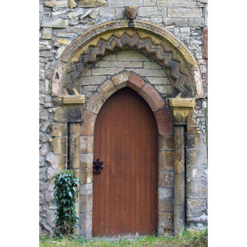
view of church exterior - north portal
Scene Description: the old Norman portal on the north side, now re-opened using the later pointed arch
view of church exterior - north side - detail
Copyright Statement: Image copyright © Michael Dibb, 2010
Image Source: digital photograph taken 10 May 2010 by Michael Dibb [www.geograph.org.uk/photo/1904623] [accessed 26 November 2014]
Copyright Instructions: CC-BY-SA-2.0
view of church exterior - south view
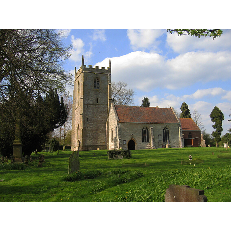
Scene Description: Source caption: "The church is next to The Old Castle, Studley, and was built c. 1105 on Saxon foundations."
Copyright Statement: Image copyright © David Stowell, 2006
Image Source: digital photograph taken 29 April 2006 by David Stowell [www.geograph.org.uk/photo/161604] [accessed 26 November 2014]
Copyright Instructions: CC-BY-SA-2.0
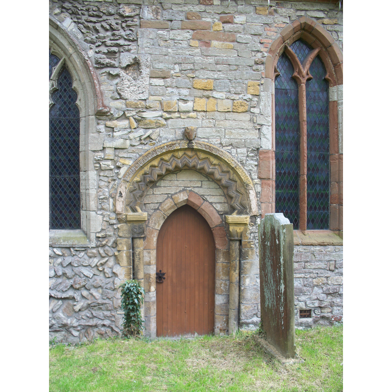
view of church exterior - north portal
![the old Norman portal on the north side, blocked at the time [ca. 1858?]](/static-50478a99ec6f36a15d6234548c59f63da52304e5/compressed/0150202046_compressed.png)
Scene Description: the old Norman portal on the north side, blocked at the time [ca. 1858?]
Copyright Statement: Image copyright © [in the public domain]
Image Source: engraving in Notices of the churches of Warwickshire (vol. 2, 1858)
Copyright Instructions: PD
view of church exterior - southeast view
![EXT OLD engraving in Notices of the churches of Warwickshire (vol. 2, 1858)
EXT OLD NORTH PORTAL engraving in Notices of the churches of Warwickshire (vol. 2, 1858)
EXT SW digital photograph taken 29 April 2006 by David Stowell [www.geograph.org.uk/photo/161604] [accessed 26 November 2014] Source caption: "The church is next to The Old Castle, Studley and was built c. 1105 on Saxon foundations."
EXT N Portal digital photograph taken 10 May 2010 by Michael Dibb [www.geograph.org.uk/photo/1904623] [accessed 26 November 2014] Source caption: "A richly decorated doorway in the north wall of the church."](/static-50478a99ec6f36a15d6234548c59f63da52304e5/compressed/0150202045_compressed.png)
Scene Description: EXT OLD engraving in Notices of the churches of Warwickshire (vol. 2, 1858)
EXT OLD NORTH PORTAL engraving in Notices of the churches of Warwickshire (vol. 2, 1858)
EXT SW digital photograph taken 29 April 2006 by David Stowell [www.geograph.org.uk/photo/161604] [accessed 26 November 2014] Source caption: "The church is next to The Old Castle, Studley and was built c. 1105 on Saxon foundations."
EXT N Portal digital photograph taken 10 May 2010 by Michael Dibb [www.geograph.org.uk/photo/1904623] [accessed 26 November 2014] Source caption: "A richly decorated doorway in the north wall of the church."
Copyright Statement: Image copyright © [in the public domain]
Image Source: engraving in Notices of the churches of Warwickshire (vol. 2, 1858)
Copyright Instructions: PD
INFORMATION
Font ID: 19535STU
Object Type: Baptismal Font1?
Font Century and Period/Style: 11th century, Pre-Conquest? / Norman
Church / Chapel Name: Parish Church of the Nativity of the Blessed Virgin Mary
Church Patron Saint(s): The Nativity of St. Mary / St. Mary
Church Address: Castle Road, Studley, West Midlands, B80 7AB
Site Location: Warwickshire, West Midlands, England, United Kingdom
Directions to Site: Located 6 km SE of Redditch, 21 km NW of Stratford-upon-Avon, near the county border with Worcestershire
Ecclesiastic Region: Diocese of Coventry
Historical Region: Hundred of Ferncombe [in Domesday times] -- Hundred of Barlichway
Additional Comments: disappeared font? (the one from the Domesday-time church here)
Font Notes:
Click to view
There are two entries for this Studley [variant spelling] in the Domesday survey [http://domesdaymap.co.uk/place/SP0763/studley/] [accessed 26 November 2014], one of which reports a priest but not a church in it, though there probably was one there. The entry for this parish in Notices of the churches of Warwickshire (vol. 2, 1858) gives the dedication of this church simply as The Blessed Virgin, and notes: "In the Domesday Survey it is written Stodlei; whence it appears, that previously to the Norman Conquest, it was chiefly possessed by a Saxon named Swain, the remaining portion belonging to Godric. The possessions of the former, containing the Church and the mill, were then granted to William, the son of Corbucion [...] A Priory for Canons of the Augustine Order was founded here by Peter Corbicon (or Peter de Stodley, as he is called from his residence here) in the reign of Stephen, [i.e., 1135-1154] which, amongst its other endowments, possessed the parish Church of Studley [...] The north wall of the nave exhibits some features of the ancient Norman church, in a somewhat rich semicircular headed doorway of the 12th century [...] There is no proper font; the substitute stands at the east end of the nave". The Victoria County History (Warwick, vol. 3, 1945) gives the dedication of this church as The Natiivity of the Blessed Virgin, and notes: " The present font is modern; it consists of a roughly hemispherical basin with a pronouned roll moulding at the upper rim, a gadrooned pattern on the sides and underbowl; on a round pedestal base with a decorated lower base [NB: according to one source [www.flickr.com/photos/tudorbarlow/2489875886/in/set-72157594207678469] [accessed 26 November 2014] who visited on 13 May 2008, the font is "used for lighted candles, it contains sand!" -- we have no information on the font of the original church here].
COORDINATES
UTM: 30U 576236 5791812
Latitude & Longitude (Decimal): 52.271396, -1.882716
Latitude & Longitude (DMS): 52° 16′ 17.03″ N, 1° 52′ 57.78″ W
REFERENCES
- Victoria County History [online], University of London, 1993-. URL: https://www.british-history.ac.uk.
- Warwickshire Natural History and Archaeological Society. Architectural Committee, Notices of the churches of Warwickshire, Rivington, London; [etc.]: Henry T. Cooke, 1847-, vol. 2: 119ff