Claverdon / Clavendone
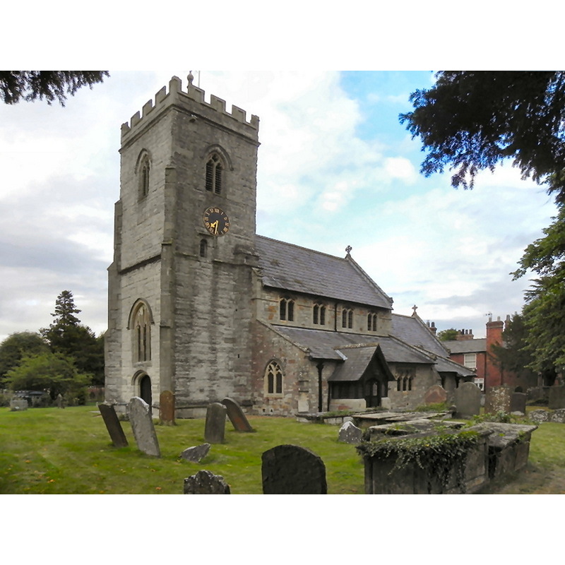
Image copyright © David Dixon, 2010
CC-BY-SA-2.0
Results: 4 records
view of church exterior - southwest view
Copyright Statement: Image copyright © David Dixon, 2010
Image Source: digital photograph taken 9 August 2010 by David Dixon [www.geograph.org.uk/photo/2031065] [accessed 20 November 2014]
Copyright Instructions: CC-BY-SA-2.0
view of church exterior - northeast view
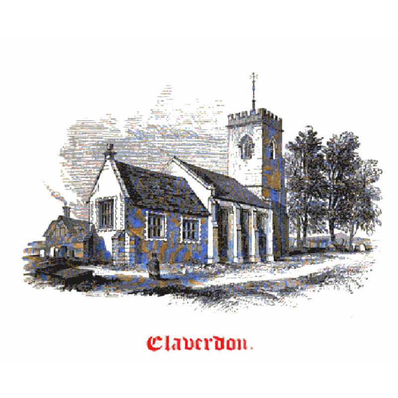
Copyright Statement: Image copyright © [in the public domain]
Image Source: engraving in Notices of the Churches of Warwickshire (vol. 2, 1858)
Copyright Instructions: PD
view of church interior - nave - looking southwest
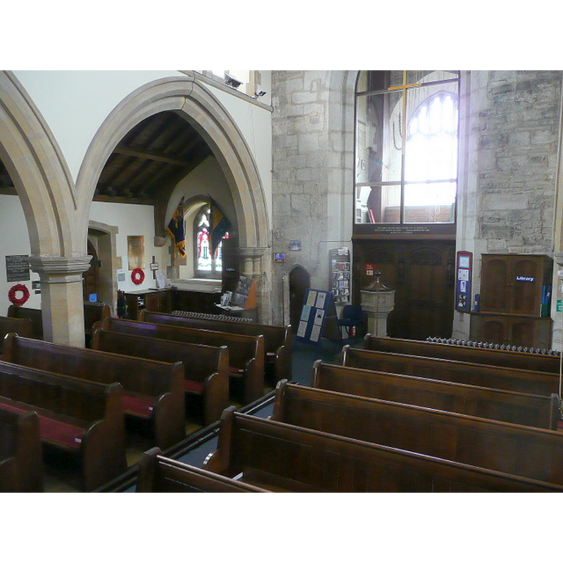
Scene Description: Source caption: "St. Michael and All Angels' church, Claverdon - interior. View from the pulpit towards the west end and ringing chamber at the base of the 15th century tower." -- the modern font and cover are visible by the tower arch
Copyright Statement: Image copyright © Jonathan Billinger, 2010
Image Source: digital photograph taken 12 March 2010 by Jonathan Billinger [www.geograph.org.uk/photo/1771037] [accessed 20 November 2014]
Copyright Instructions: CC-BY-SA-2.0
view of church interior - nave - looking east
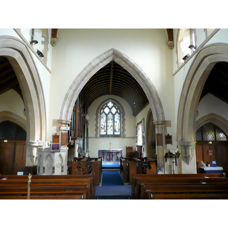
Scene Description: Source caption: "St. Michael and All Angels' church, Claverdon - interior. Looking along the Victorian nave and chancel"
Copyright Statement: Image copyright © Jonathan Billinger, 2010
Image Source: digital photograph taken 12 March 2010 by Jonathan Billinger [www.geograph.org.uk/photo/1771036] [accessed 20 November 2014]
Copyright Instructions: CC-BY-SA-2.0
INFORMATION
Font ID: 19523CLA
Object Type: Baptismal Font1?
Font Century and Period/Style: 11th century, Pre-Conquest? / Norman
Church / Chapel Name: Parish Church of St. Michael and All Angels
Church Patron Saint(s): St. Michael & All Angels
Church Address: Church Road, Claverdon, Warwickshire CV35 8NT
Site Location: Warwickshire, West Midlands, England, United Kingdom
Directions to Site: Located 10 km W of Warwick
Ecclesiastic Region: Diocese of Coventry
Historical Region: Hundred of Ferncombe [in Domesday times] -- Hundred of Barlichway
Additional Comments: disappeared font? (the one from the possible Domesday-time church here) re-cycled font? (NB: the basin form an old font from this church was reported in a nearby farm ca. 1858 [cf. FontNotes])
Font Notes:
Click to view
There is an entry for Claverdon [variant spelling] in the Domesday survey [http://domesdaymap.co.uk/place/SP1964/claverdon/] [accessed 20 November 2014]; it reports a priest in it, but does not mention a church, though there probably was one there. Notices of the Churches in Warwickshire (vol. 2, 1858) reports that Claverdon "possessed a Church at the period of the Norman Conquest", a church re-built in 1830 into what the authors describe as "un-church-like"; on the font they write: "There is no Font in the Church, but the one belonging to it is believed to be still in existence: and the basin of it, said to be in a farm yard. This act of desecration ought not to be permited [...] In lieu of the Font is a wooden pedestal to hold a common basin, which is expressly forbidden by the Canons: 'Curabunt ut in singulis Ecclesiis sit Sacer Fons, non Pelvis, in quo Baptismus ministretur.' Why do not the Churchwardens comply with this Canon and restore the ancient Font so sacrilegiously removed?" The Victoria County History Warwick, vol. 3, 1945) notes: "About 1150 Hugh son of Richard, of Hatton, and Margaret his wife, [...] gave to the Abbey of St. Florent, Saumur, and its cell the Priory of Monmouth the church of St. Michael of Claverdon, to which the chapels of Langley, Norton, and Wolverton were appurtenant"; according to the VCH entry there appears to be nothing earlier than the 14th century in the present church; no font mentioned. No font mentioned either in the English Heritage entry for this church [Listing NGR: SP1983164577] (1967). At some point since 1858 the offensive font [cf. supra] mut have been replaced by a more 'normal' one; the present one, of stone, is of the octagonal all over type, with decorated basin sides and moulded underbowl, on a moulded octagonal pedestal base; the wooden cover is also decorous, octagonal, with a ball finial. It is located at the west end of the nave, jus east of the tower arch.
COORDINATES
UTM: 30U 587954 5792844
Latitude & Longitude (Decimal): 52.278922, -1.710765
Latitude & Longitude (DMS): 52° 16′ 44.12″ N, 1° 42′ 38.75″ W
MEDIUM AND MEASUREMENTS
Material: stone
REFERENCES
- Victoria County History [online], University of London, 1993-. URL: https://www.british-history.ac.uk.
- Warwickshire Natural History and Archaeological Society. Architectural Committee, Notices of the churches of Warwickshire, Rivington, London; [etc.]: Henry T. Cooke, 1847-, vol. 2: 27-33