East Somerton / Somerton East / Somertuna
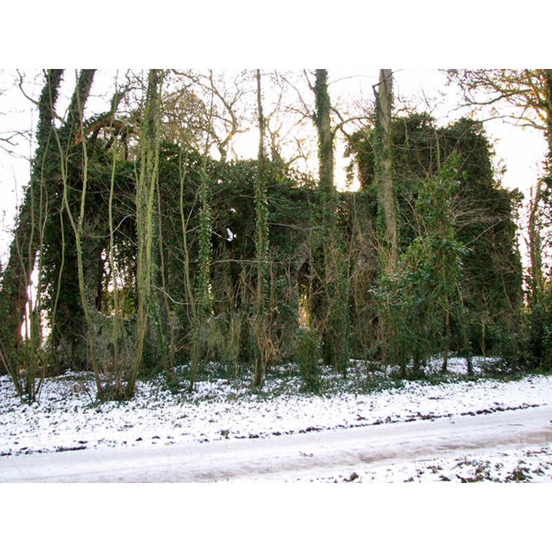
Image copyright © Evelyn Simak, 2010
CC-BY-SA-3.0
Results: 3 records
view of church exterior - northeast view
Scene Description: Photo caption: "It is situated in a woodland adjoining Burnley Hall. During summer the ruined church can easily be passed unseen but the bare winter trees allow a glimpse of the ivy-covered structure."
Copyright Statement: Image copyright © Evelyn Simak, 2010
Image Source: digital photograph taken 21 December 2010 by Evelyn Simak [www.geograph.org.uk/photo/2204640] [accessed 21 May 2014]
Copyright Instructions: CC-BY-SA-3.0
view of church exterior - north view
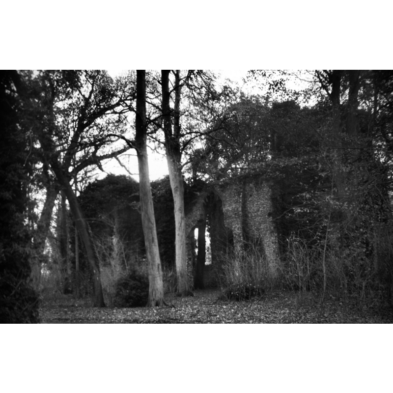
Scene Description: Photo caption: "Abandoned by the 17c"
Copyright Statement: Image copyright © George Plunkett, 2014
Image Source: B&W photograph taken 26 November 1999 by George Plunkett [www.georgeplunkett.co.uk/Norfolk/E/E Somerton St Mary's church ruin north side [7714] 1999-11-26.jpg] [accessed 27 May 2014]
Copyright Instructions: Standing permission by Jonathan Plunkett
view of church interior - nave - looking west
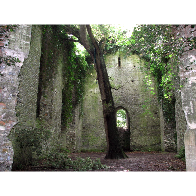
Scene Description: inside the ruins of St. Mary's
Copyright Statement: Image copyright © Evelyn Simak, 2007
Image Source: digital photograph taken 9 July 2007 by Evelyn Simak [www.geograph.org.uk/photo/519965] [accessed 21 May 2014]
Copyright Instructions: CC-BY-SA-3.0
INFORMATION
Font ID: 19231SOM
Object Type: Baptismal Font1?
Font Century and Period/Style: 11th century, Norman
Church / Chapel Name: Parish Church of St. Mary [in ruins]
Church Patron Saint(s): St. Mary the Virgin
Church Address: Back Road, Somerton, Norfolk NR29 4DZ
Site Location: Norfolk, East Anglia, England, United Kingdom
Directions to Site: Located in the grounds of Burnley Hall, near Winterton, 15 km N of Gt Yarmouth, 35 km NE of Norwich
Ecclesiastic Region: [Diocese of Norwich]
Historical Region: Hundred of West Flegg
Additional Comments: disappeared font? (we have no information on the font of the Domesday-time church here)
Font Notes:
Click to view
There are six entries for East and West Somerton [variant spelling] in the Domesday survey [http://domesdaymap.co.uk/place/XX0000/east-and-west-somerton/] [accessed 27 May 2014], one of which reports a church in it. There are nine entries for Winterton [variant spelling] in the Domesday survey [http://domesdaymap.co.uk/place/TG4919/winterton/] [accessed 28 May 2014], one of which reports a church and churchlands in it. In his entry for Wintretuna, in which a church is noted, Blomefield (1805-1810) writes: "The church here mentioned was that of East Somerton, and at that time was a distint parish, and had its own rector" [the "here" in Blomefield's text is his transcription of the Domesday entry: "In Wintretuna viii lib. ho'es Almari comd. tantu. xiiii ac. terre. semp. dim. car. tc. val. viiid. mo. xxiiii. In Somertuna iii lib. ho'es T. R. E. sed. postq. Tostius exiit de Anglia Bernard. fuit i ecc'lia S. Bened. de Hulmo. tenuit cvi ac. terre ix ac. p'ti. sep. ix bord. sep. i car. et dim. semp. val. iiii sol, et viiid." By contrat the Blomefield entry for East Somerton does not mention the Domesday-time church, and the earliest reference to a church in it is in relation to an agreement on presentation of the priests here: "in the 4th of Edward I [i.e., 1276] Alexander, son of Richard Fastolf, and Bartholomew de Somerton agreed by fine to present alternately to the church of East Somerton, and the church of Winterton. In 1310, Sir Bartholomew de Somerton presented to the church of Winterton, and chapel of East Somerton." There are several erefences in Blomefield (ibid.) to the "chapel" and the "church" of East Somerton, including one that reads: "There was formerly a chapel in East Somerset [sic] into which the rectors of Winterton are instituted, but has been in ruins many years; it was dedicated to St. Mary." [cf. Index entry for Winterton].
Knott (2006) writes: "St Mary survived the Reformation, but the parish was subsumed into that of neighbouring Winterton, and it operated as a chapel of ease to the Hall until the 17th century Commonwealth, before falling into disuse. It is likely that the chancel was lost and in ruins even before that, and probably this accelerated its demise. There really is no trace left of the chancel at all".
Knott (2006) writes: "St Mary survived the Reformation, but the parish was subsumed into that of neighbouring Winterton, and it operated as a chapel of ease to the Hall until the 17th century Commonwealth, before falling into disuse. It is likely that the chancel was lost and in ruins even before that, and probably this accelerated its demise. There really is no trace left of the chancel at all".
COORDINATES
UTM: 31U 410209 5841737
Latitude & Longitude (Decimal): 52.718064, 1.670654
Latitude & Longitude (DMS): 52° 43′ 5.03″ N, 1° 40′ 14.35″ E
REFERENCES
- Blomefield, Francis, An essay towards a topographical history of Norfolk, 1805-1810, vol. 11: 191-192 / [www.british-history.ac.uk/report.aspx?compid=78782] [accessed 27 May 2014]
- Blomefield, Francis, An essay towards a topographical history of Norfolk, 1805-1810, vol. 11: 193-199 / [www.british-history.ac.uk/report.aspx?compid=78783] [accessed 27 May 2014]