Burgh St. Mary / Burc / Burgh / Fleggburgh
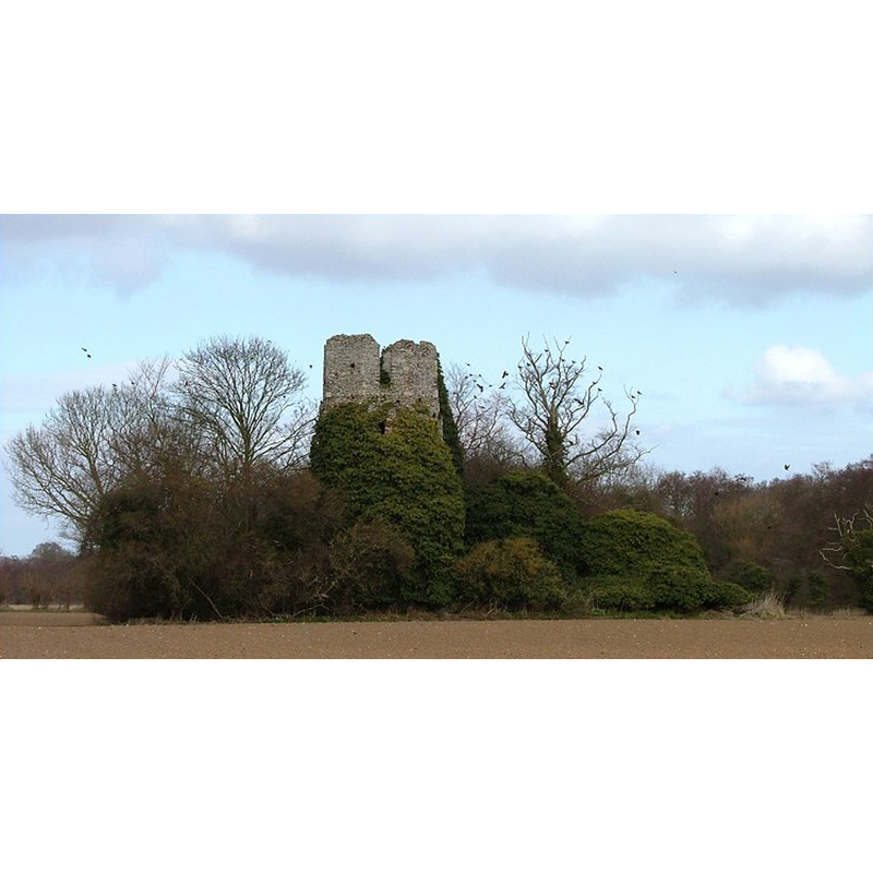
Image copyright © Simon Knott, 2006
Standing permission
Results: 2 records
view of church exterior
Scene Description: the ruins in 2006
Copyright Statement: Image copyright © Simon Knott, 2006
Image Source: digital photograph March 2006 taken by Simon Knott [www.norfolkchurches.co.uk/burghmary/burghmary.htm] [accessed 23 May 2014]
Copyright Instructions: Standing permission
view of church exterior
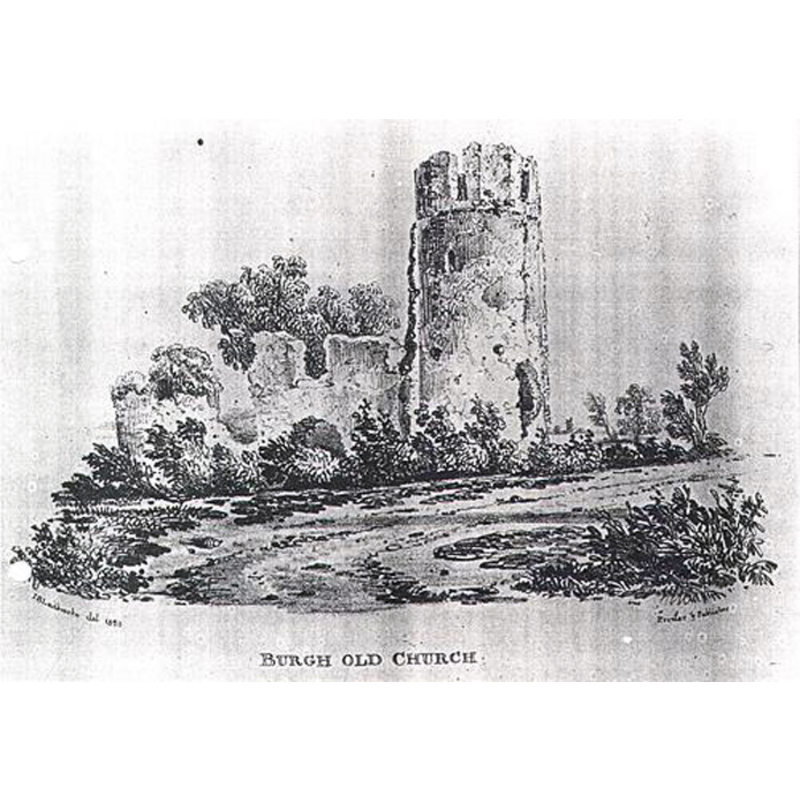
Scene Description: the ruins in 1891 -- Image caption: "The ruins of St Mary's Church, Burgh St Mary"
Copyright Statement: Image copyright © [in the public domain]
Image Source: 1891 B&W drawing ruins of old st mary's -- source of the original unknown -- in [http://hbsmrgateway2.esdm.co.uk/norfolk/DataFiles/FullImages/1322.jpg] [accessed 23 May 2013]
Copyright Instructions: PD
INFORMATION
Font ID: 19220BUR
Object Type: Baptismal Font1?
Font Century and Period/Style: 12th - 14th century, Medieval
Church / Chapel Name: Parish Church of St. Mary [in ruins]
Church Patron Saint(s): St. Mary the Virgin
Church Notes: round-tower church [mostly in ruins now but a 1891 drawing shows the round tower clearly]
Church Address: Tower Road, Fleggburgh, Norfolk NR29 3AR
Site Location: Norfolk, East Anglia, England, United Kingdom
Directions to Site: Fleggburgh is 12 kms NW of Gt. Yarmouth, 25 km E of Norwich
Ecclesiastic Region: Diocese of Norwich
Historical Region: Hundred of West Flegg
Additional Comments: disappeared font? (the one from the disappeared medieval church here)
Font Notes:
Click to view
There are six entries for this Burgh [variant spelling] in the Domesday survey [http://domesdaymap.co.uk/place/TG4414/burgh-st-margaret/] [accessed 23 May 2014], but not a single church or cleric is reported in them. Blomefield (1805-1810) writes: "In this town were two churches, St. Margaret's and St. Mary's", and notes that the presentation of "Stephen Alleyn" as first recorded rector of this church took place in 1317, even though the church itself is believed to have existed as early as the 12th century. The Church of St. Mary must have been on the decline in the 16th century, for, after 1554, "the rectors were the same as in St. Margaret. This church is now [i.e., at the time of Blomefield's writing, in mid-18th century] in ruins." Kelly's Directory for Cambridgeshire, Norfolk & Suffolk (1883: 263) [http://apling.freeservers.com/Villages/FleggBurgh.htm] [accessed 23 May 2014] notes: "The old church of St. Mary has gone to decay, with the exception of a small portion of the tower, which remains in the centre of a field." Knott (2006) writes: "In the middle of a wide, ploughed field just to the west of Caister, this magnificent ruin stands, like a castle adrift on a brown sea, a city of the plain. [...] Burgh St Mary is not to be confused with Burgh-next-Aylsham and Burgh Parva, both of which have churches dedicated to St Mary. The parish here is adjacent to Burgh St Margaret, and after the Reformation this was the church which fell into disuse. Ironically, St Margaret was almost completely rebuilt in the 1870s, and so more of the medieval St Mary survives than of St Margaret."
COORDINATES
UTM: 31U 407229 5836335
Latitude & Longitude (Decimal): 52.669008, 1.628069
Latitude & Longitude (DMS): 52° 40′ 8.43″ N, 1° 37′ 41.05″ E
REFERENCES
- Blomefield, Francis, An essay towards a topographical history of Norfolk, 1805-1810, vol. 11: 152-156 / [www.british-history.ac.uk/report.aspx?compid=78772] [accessed 23 May 2014]
- Knott, Simon, The Norfolk Churches Site, Simon Knott, 2004. [standing permission to reproduce images received from Simon (February 2005]. URL: www.norfolkchurches.co.uk.