North Wootton nr. King's Lynn / North Wotton / Wdetuna
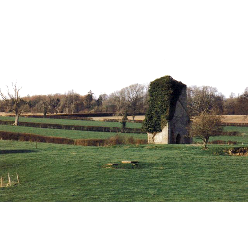
Image copyright © Chris Downer, 1998
CC-BY-SA-3.0
Results: 4 records
view of church exterior - southeast view
Scene Description: only the west tower remains now from the old church; the image shows the south and east sides of the tower; on the latter the contour of the nave roof is partially visible
Copyright Statement: Image copyright © Chris Downer, 1998
Image Source: photograph taken in 1998 by Chris Downer [www.geograph.org.uk/photo/473382] [accessed 10 December 2013]
Copyright Instructions: CC-BY-SA-3.0
view of church exterior - southwest view
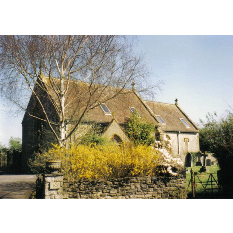
Scene Description: the middle church, now a private dwelling
Copyright Statement: Image copyright © Chris Downer, 2000
Image Source: photograph taken in 2000 by Chris Downer [www.geograph.org.uk/photo/473379] [accessed 10 December 2013]
Copyright Instructions: CC-BY-SA-3.0
view of church exterior - southeast view
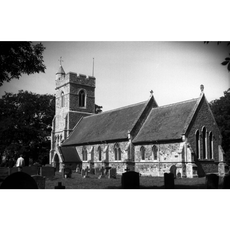
Scene Description: the new church -- Photo caption: "Built in 1852. Architect Salvin"
Copyright Statement: Image copyright © George Plunkett, 2013
Image Source: B&W photograph taken 15 September 1996 by George Plunkett [www.georgeplunkett.co.uk/Norfolk/N/N Wootton All Saints church from SE [7403] 1996-09-15.jpg] [ accessed 10 December 2013]
Copyright Instructions: Standing permission by Jonathan Plunkett
view of church exterior - southeast view
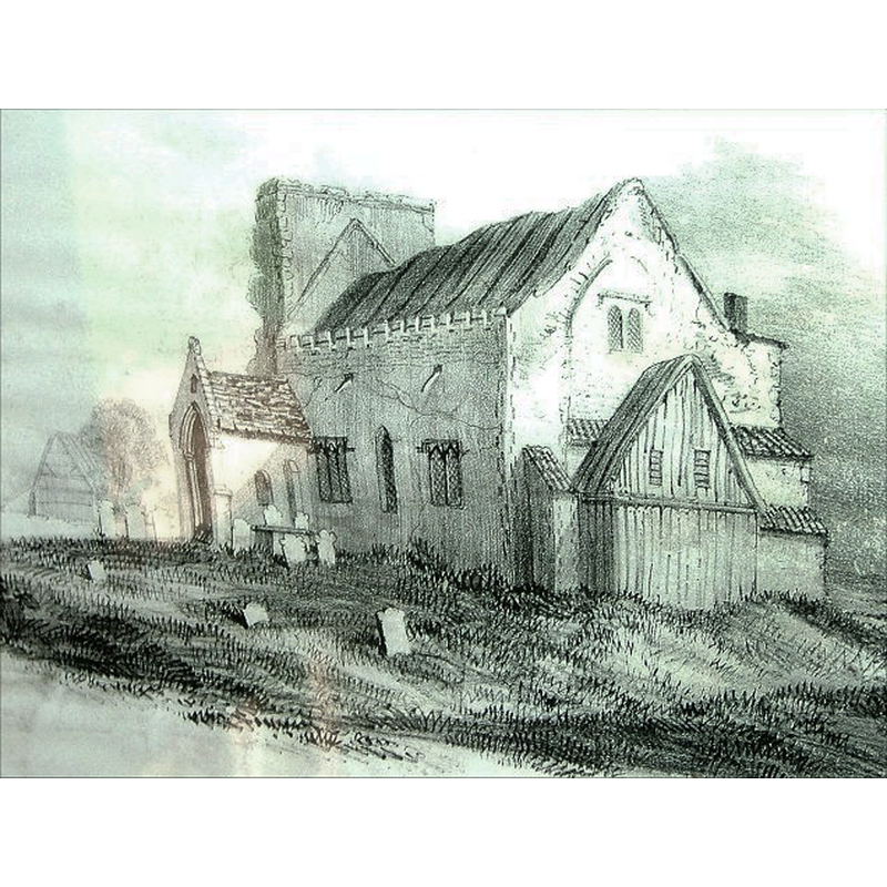
Copyright Statement: Image copyright © [in the public domain]
Image Source: digital photograph of a 1820s drawing by Robert Ladbrooke, in Knott [www.norfolkchurches.co.uk/northwooton/images/dscf3276.jpg] [accessed 17 December 2013]
Copyright Instructions: Standing permission
INFORMATION
Font ID: 18869WOO
Object Type: Baptismal Font1?
Font Century and Period/Style: 12th - 13th century, Medieval
Church / Chapel Name: Old Parish Church of All Saints
Church Patron Saint(s): All Saints
Church Notes: only the ruins of the tower remain from the old church; its replacement is now a private dwelling (nave and chancel)
Church Address: Manor Road, North Wootton, Norfolk, PE30 3PZ [address of the new church]
Site Location: Norfolk, East Anglia, England, United Kingdom
Directions to Site: North Wootton is now a suburb of King's Lynn, 6 km to the N of the town centre
Additional Comments: disappeared font? (the one from the 12th-13thC church here)
Font Notes:
Click to view
There is a single entry for both North and South Wootton in the Domesday survey [http://domesdaymap.co.uk/place/XX0000/north-and-south-wootton/] [accessed 10 December 2013], recorded as "Wdetuna", but it mentions neither church nor cleric in it. Blomefield (1805-1810) writes: "This and South Wotton, as I have observed, made, at the survey, one town, and belonged to one lord [...] The Church is dedicated to All-Saints, was formerly a rectory [...] William de Albini Earl of Sussex, grandson to the founder of Windham priory, gave to the said monastery, the rectory of this church [...] Thomas de Blundevile Bishop of Norwich appropriated it, and a vicarage was settled". This "William de Albini" is William d'Aubigny "third earl of Arundel (c.1174–1221)" [Ralph V. Turner, ‘Aubigny, William d' , third earl of Arundel (c.1174–1221)’, Oxford Dictionary of National Biography, Oxford University Press, 2004 [www.oxforddnb.com/view/article/283, accessed 10 Dec 2013]]. Blundeville died 16 August 1236 [Christopher Harper-Bill, ‘Blundeville, Thomas de (d. 1236)’, Oxford Dictionary of National Biography, Oxford University Press, 2004; online edn, May 2007 [www.oxforddnb.com/view/article/2717, accessed 10 Dec 2013]]. The church here, therefore, appears to have been built between 1086 and 1221 at the latest. White's Directory of 1845 reports: "The church was repaired in 1834, [...] except the tower, which is in ruins, only two of its walls remaining"; the 1883 edition of the Directory [www.origins.org.uk/genuki/NFK/places/w/wootton_north/white1883.shtml] [accessed 10 December 2013] notes the re-building of the old church: "(All Saints) was rebuilt in the Early English style in 1853". The entry from English Heritage [Listing NGR: TF6400424321] reads: "Parish church, 1852, by A. Salvin totally replacing medieval church". Knott (2005) writes: "The medieval parish church here was in a very sorry state by the early 19th century; the tower had collapsed, the chancel had been taken down, and the porch was leaning at a very odd angle - or that could just be the perspective of my photograph of the photocopy of Ladbroke's drawing hanging up in the porch. It was completely demolished in 1850". [NB: this reference must be to a lithograph of this church by Robert Ladbrooke in one of the two editions of his work on Norfolk churches, 1836 and 1843; the drawings themselves seem to have been completed in the 1820s].
COORDINATES
UTM: 30U 535737 5642333
Latitude & Longitude (Decimal): 50.931524, -2.491448
Latitude & Longitude (DMS): 50° 55′ 53.48″ N, 2° 29′ 29.21″ W
REFERENCES
- Blomefield, Francis, An essay towards a topographical history of Norfolk, 1805-1810, vol. 9: 201-204 / [www.british-history.ac.uk/report.aspx?compid=78526] [accessed 10 December 2013]
- Knott, Simon, The Norfolk Churches Site, Simon Knott, 2004. [standing permission to reproduce images received from Simon (February 2005]. URL: www.norfolkchurches.co.uk.
- Ladbrooke, Robert, Views of the churches of Norfolk, Norwich: Published by Charles Muskett [...], 1843
- White, William, History, gazetteer, and directory of Norfolk and the city and County of the city of Norwich [...], Sheffield: Robert Leader, 1845, [transcribed in www.origins.org.uk/genuki/NFK/places/w/wootton_north/white1845.shtml [accessed 10 December 2013]]