Boughton / Boughton nr. Stoke Ferry / Buchetuna / Buckton
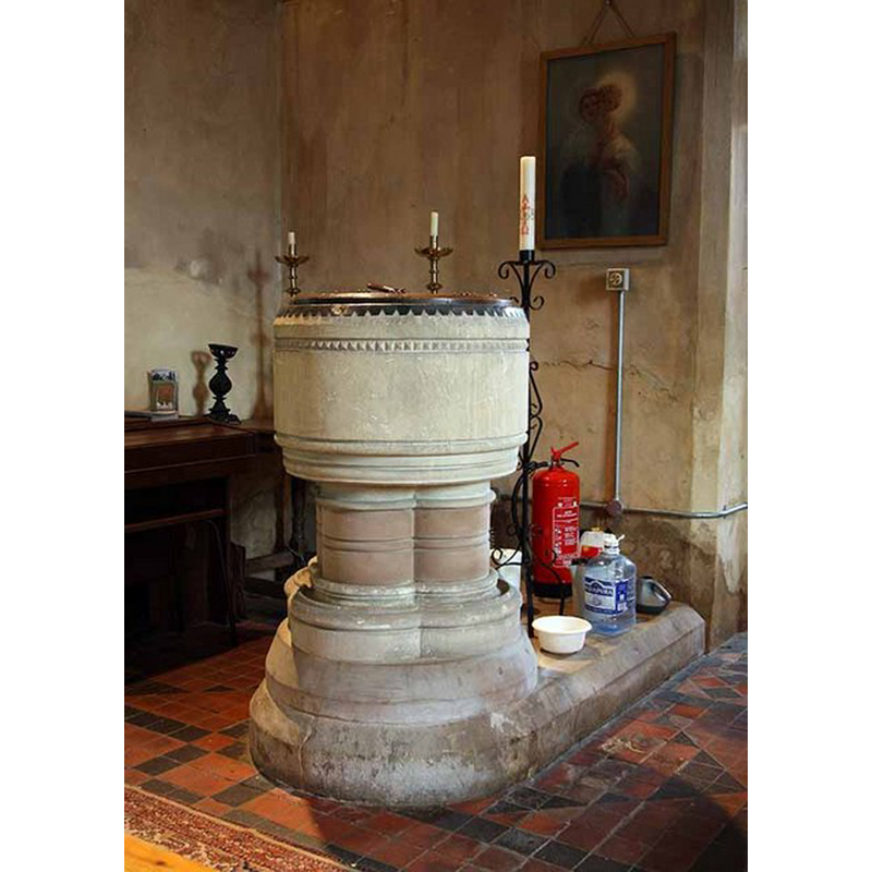
Image copyright © John Salmon, 2008
CC-BY-SA-3.0
Results: 5 records
view of font and cover
Scene Description: the modern font [cf. FontNotes]
Copyright Statement: Image copyright © John Salmon, 2008
Image Source: digital photograph taken 29 August 2008 by John Salmon [www.geograph.org.uk/photo/942502] [accessed 14 August 2013]
Copyright Instructions: CC-BY-SA-3.0
view of church exterior - southeast view
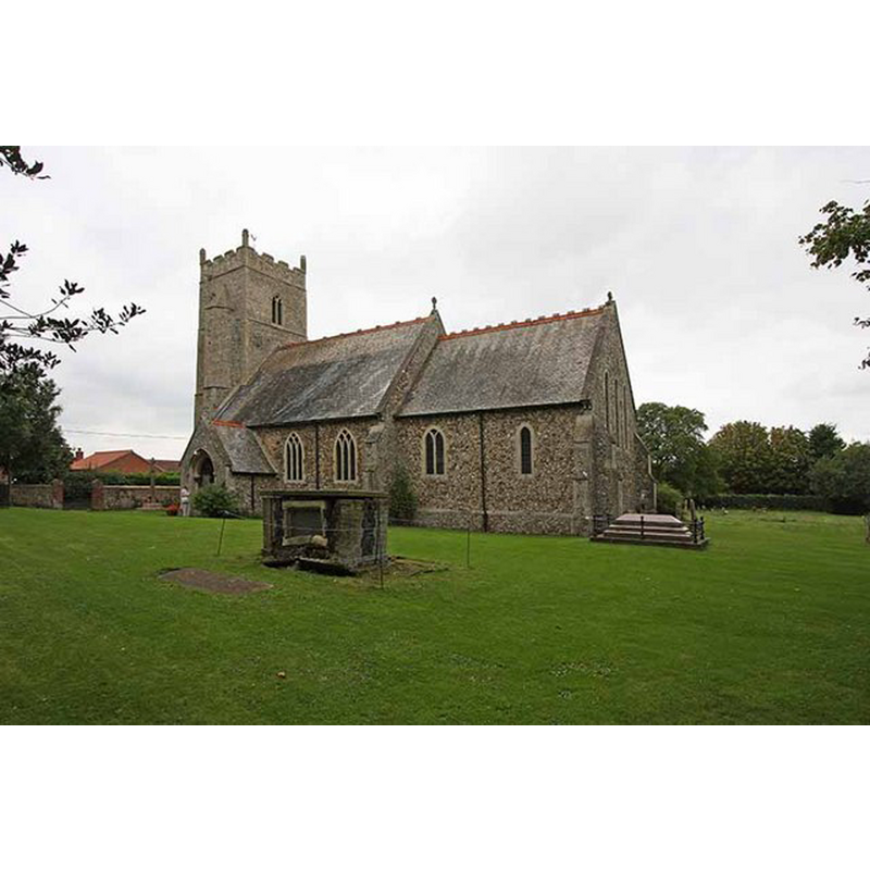
Copyright Statement: Image copyright © John Salmon, 2008
Image Source: digital photograph taken 29 August 2008 by John Salmon [www.geograph.org.uk/photo/942941] [accessed 14 August 2013]
Copyright Instructions: CC-BY-SA-3.0
view of church exterior - northeast view
![EXT NE B&W photograph taken 31 October 1993 by George Plunkett [www.georgeplunkett.co.uk/Norfolk/B/Boughton All Saints church from NE [7102] 1993-10-31.jpg] [accessed 14 August 2013]
EXT SE digital photograph taken 29 August 2008 by John Salmon [www.geograph.org.uk/photo/942941] [accessed 14 August 2013]
INT E digital photograph taken 29 August 2008 by John Salmon [www.geograph.org.uk/photo/942497] [accessed 14 August 2013]
INT W digital photograph taken 29 August 2008 by John Salmon [www.geograph.org.uk/photo/942500] [accessed 14 August 2013]
FONT digital photograph taken 29 August 2008 by John Salmon [www.geograph.org.uk/photo/942502] [accessed 14 August 2013]](/static-50478a99ec6f36a15d6234548c59f63da52304e5/compressed/1130814012_compressed.png)
Scene Description: EXT NE B&W photograph taken 31 October 1993 by George Plunkett [www.georgeplunkett.co.uk/Norfolk/B/Boughton All Saints church from NE [7102] 1993-10-31.jpg] [accessed 14 August 2013]
EXT SE digital photograph taken 29 August 2008 by John Salmon [www.geograph.org.uk/photo/942941] [accessed 14 August 2013]
INT E digital photograph taken 29 August 2008 by John Salmon [www.geograph.org.uk/photo/942497] [accessed 14 August 2013]
INT W digital photograph taken 29 August 2008 by John Salmon [www.geograph.org.uk/photo/942500] [accessed 14 August 2013]
FONT digital photograph taken 29 August 2008 by John Salmon [www.geograph.org.uk/photo/942502] [accessed 14 August 2013]
Copyright Statement: Image copyright © George Plunkett, 2013
Image Source: B&W photograph taken 31 October 1993 by George Plunkett [www.georgeplunkett.co.uk/Norfolk/B/Boughton All Saints church from NE [7102] 1993-10-31.jpg] [accessed 14 August 2013]
Copyright Instructions: Standing permission by Jonathan Plunkett
view of church interior - nave - looking west
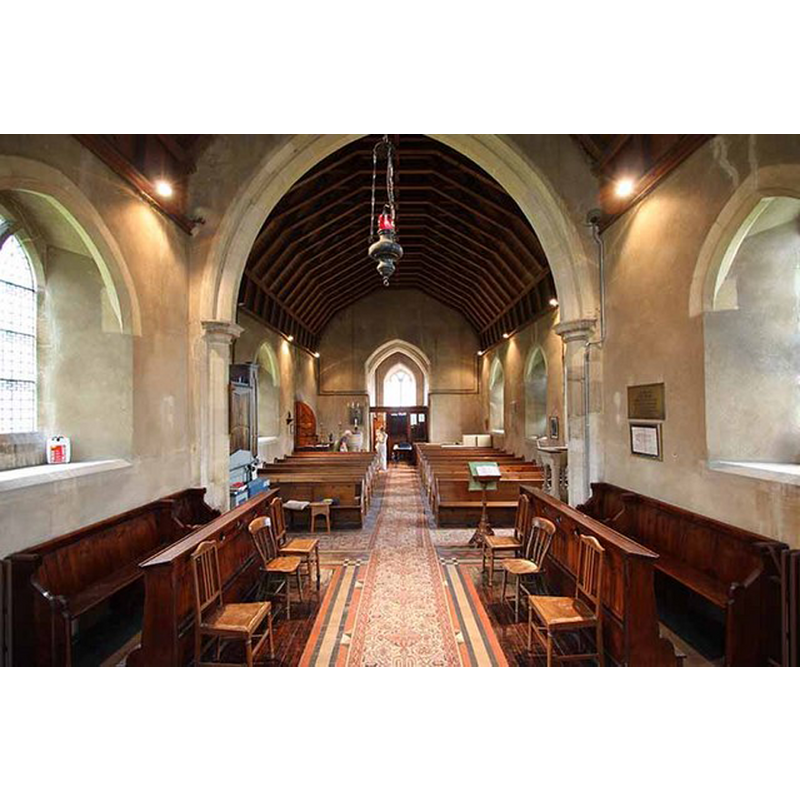
Copyright Statement: Image copyright © John Salmon, 2008
Image Source: digital photograph taken 29 August 2008 by John Salmon [www.geograph.org.uk/photo/942500] [accessed 14 August 2013]
Copyright Instructions: CC-BY-SA-3.0
view of church interior - nave - looking east
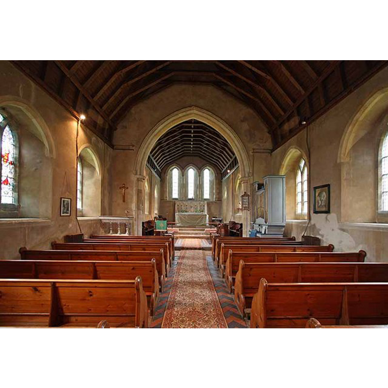
Copyright Statement: Image copyright © John Salmon, 2008
Image Source: digital photograph taken 29 August 2008 by John Salmon [www.geograph.org.uk/photo/942497] [accessed 14 August 2013]
Copyright Instructions: CC-BY-SA-3.0
INFORMATION
Font ID: 18600BOU
Object Type: Baptismal Font1?
Font Century and Period/Style: 13th century, Medieval
Church / Chapel Name: Parish Church of All Saints
Church Patron Saint(s): All Saints
Church Address: Church Lane, Boughton, Norfolk, PE33 9AQ
Site Location: Norfolk, East Anglia, England, United Kingdom
Directions to Site: Located 3 km N of Stoke Ferry
Ecclesiastic Region: Diocese of Ely [formerly Norwich]
Historical Region: Hundred and half of Clackclose
Additional Comments: disappeared font? (the one of the medieval church here)
Font Notes:
Click to view
Blomedfield (1805-1810) writes: "B[uckton], or B[oughton], Called Buchetuna in Domesday [...] The Church is dedicated to All-Saints, and is an ancient building, built of flint and boulder; the nave is about 36 feet in length, and about 23 in breadth, covered with thatch; at the west end stands a four square tower of the aforesaid materials, embattled, with quoins &c. ornamented with 4 pinnacles of free stone; on this a spire of wood covered with lead: this tower was erected about the year 1416, when John Elvered, rector of Oxburgh, left, by will, 3s. 4d. to the new tower here, in which hang 3 bells. The chancel is in length about 25 feet, and in breadth about 16, covered with thatch, &c. and the communion table is railed in. On the top of the spire was a cross, which, in 1644, was taken down [...] Roger de Hingham, rector here in the reign of Henry III.[i.e., 1216-1272] gave considerable lands to the abbey of West Derham, with his body to be buried there." The present font is modern (19th-century?), of 13th-century design, a cylindical basin raised on three columns with moulded capitals and bases. The wooden cover round and flat, with metal ring handle; also modern, probably Victorian as well. [NB: we have no information on the font from the medieval church here].
Credit and Acknowledgements: We are grateful to Jonathan Plunkett for the photograph of this church taken by his father, George Plunkett, 31 October 1993
COORDINATES
UTM: 31U 331206 5829752
Latitude & Longitude (Decimal): 52.591555, 0.508077
Latitude & Longitude (DMS): 52° 35′ 29.6″ N, 0° 30′ 29.08″ E
REFERENCES
- Blomefield, Francis, An essay towards a topographical history of Norfolk, 1805-1810, vol. 7: 299-303 / [www.british-history.ac.uk/report.aspx?compid=78356] [accessed 14 August 2013]