Mannington / Manictuna
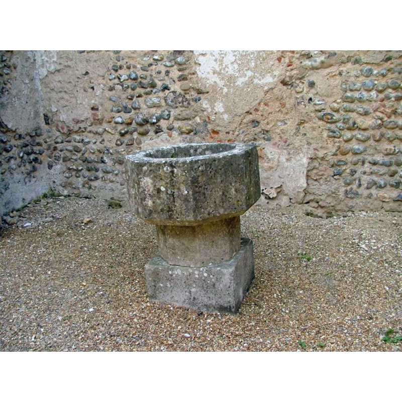
Image copyright © Simon Knott, 2005
Standing permission
Results: 4 records
view of font
Scene Description: [cf. FontNotes]
Copyright Statement: Image copyright © Simon Knott, 2005
Image Source: digital photograph September 2005 taken by Simon Knott [www.norfolkchurches.co.uk/mannington/mannington.htm] [accessed 30 May 2013]
Copyright Instructions: Standing permission
view of church exterior - southwest view
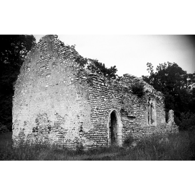
Scene Description: the tower must have collapsed much earlier, unless it was a stand-alone belfry
Copyright Statement: Image copyright © George Plunkett, 2013
Image Source: B&W photograph taken by George Plunkett [www.georgeplunkett.co.uk/Norfolk/M/Mannington church ruin from SW [6018] 1979-06-17.jpg] [accessed 31 May 2013]
Copyright Instructions: Standing permission by Jonathan Plunkett
view of church exterior - southeast view - detail
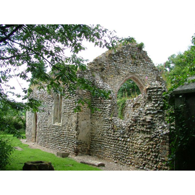
Copyright Statement: Image copyright © Simon Knott, 2005
Image Source: digital photograph September 2005 taken by Simon Knott [www.norfolkchurches.co.uk/mannington/mannington.htm] [accessed 30 May 2013]
Copyright Instructions: Standing permission
view of church interior - nave
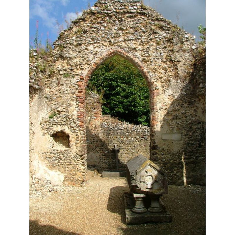
Scene Description: looking east toward the chancel?
Copyright Statement: Image copyright © Simon Knott, 2005
Image Source: digital photograph September 2005 taken by Simon Knott [www.norfolkchurches.co.uk/mannington/mannington.htm] [accessed 30 May 2013]
Copyright Instructions: Standing permission
INFORMATION
Font ID: 18477MAN
Object Type: Baptismal Font1
Font Century and Period/Style: 14th - 15th century, Medieval
Church / Chapel Name: Parish Church of St. Mary [in ruins]
Font Location in Church: Inside the ruins of the church
Church Patron Saint(s): St. Mary the Virgin
Church Notes: the church may have been abandoned since the early 18th century
Church Address: Itteringham, Norfolk NR11 7BB
Site Location: Norfolk, East Anglia, England, United Kingdom
Directions to Site: Located 9 km NW of Aylsham
Ecclesiastic Region: [Diocese of Norwich]
Historical Region: Hundred of South Erpingham
Additional Comments: disappeared font? (the one from the original 13thC (?) church here)
Font Notes:
Click to view
Blomefield (1805-1810) writes: "The Parish Church is a small pile, built by the Earl of Pembroke, the arms of the family De Valentia being carved in stone over the door; it has no steeple, or bell, the nave and chancel tiled, but now falling much into decay; it had till lately service once a month", and names "John de Watenhull" as first recorded rector here, in 1324. There is no dedication given in Blomefield. [NB: the 'Earl' mentioned above would be William de Valence [aka Valentia] (ca.1225-1296), Earl of Pembroke, or his son Aymer (ca.1265-1324), the two 'De Valence' who held the title, putting the date of this church probably into the 13th century]. White's Gazetteer of 1845 reports: "The [church] has long been a neglected ruin, and its discharged rectory, valued in the King's Book at £6. 13s. 4d., is consolidated with Itteringham." Knott (2005) writes: "all that remains is a well-maintained shell [...] The features are a combination of Early English and Perpendicular, but there is a blocked doorway in the west wall which appears to have been Norman. Was there ever a tower here, I wonder, and was this actually the tower arch rather than a doorway? The ruin itself is completely safe, the flint walls repointed and the internal floor being filled with crunchy gravel. You enter through the south doorway, and inside is a rather wonky font which may or may not have come from here". The 'wonky' font reported in Knott [cf. supra] is located inside the ruins in the part that appears to have been the nave; it consists of an octagonal basin raised on a short octagonal stem and a square lower base; it is totally plain and could be late-medieval, or much later. [NB: we have no information on the font of the original church here].
Credit and Acknowledgements: We are grateful to Simon Knott, of Norfolk Churches [www.norfolkchurches.co.uk], for his photographs of this church and font; and to Jonathan Plunkett for the photograph of this church, taken by his father, George Plunkett, in June 1979
COORDINATES
UTM: 31U 377334 5856219
Latitude & Longitude (Decimal): 52.841732, 1.178747
Latitude & Longitude (DMS): 52° 50′ 30.23″ N, 1° 10′ 43.49″ E
MEDIUM AND MEASUREMENTS
Material: stone
Font Shape: octagonal, mounted
Basin Interior Shape: round
Basin Exterior Shape: octagonal
REFERENCES
- Blomefield, Francis, An essay towards a topographical history of Norfolk, 1805-1810, vol. 6: 463-468 / [www.british-history.ac.uk/report.aspx?compid=78279] [accessed 30 May 2013]
- White, William, History, gazetteer, and directory of Norfolk and the city and County of the city of Norwich [...], Sheffield: Robert Leader, 1845, [transcribed in www.origins.org.uk/genuki/NFK/places/m/mannington/white1845.shtml] [accessed 30 May 2013]]