Waldron
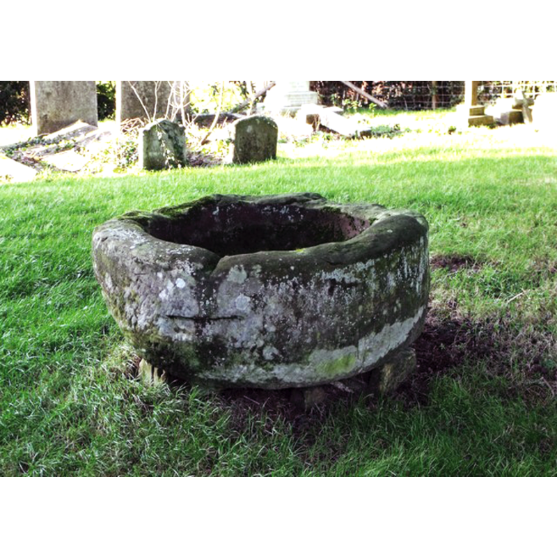
Image copyright © Nick Macneill, 2012
CC-BY-SA-3.0
Results: 5 records
view of basin in context
Copyright Statement: Image copyright © Nick Macneill, 2012
Image Source: digital photograph taken 6 January 2012 by Nick Macneill [www.geograph.org.uk/photo/2767090] [accessed 6 February 2013]
Copyright Instructions: CC-BY-SA-3.0
view of basin - interior
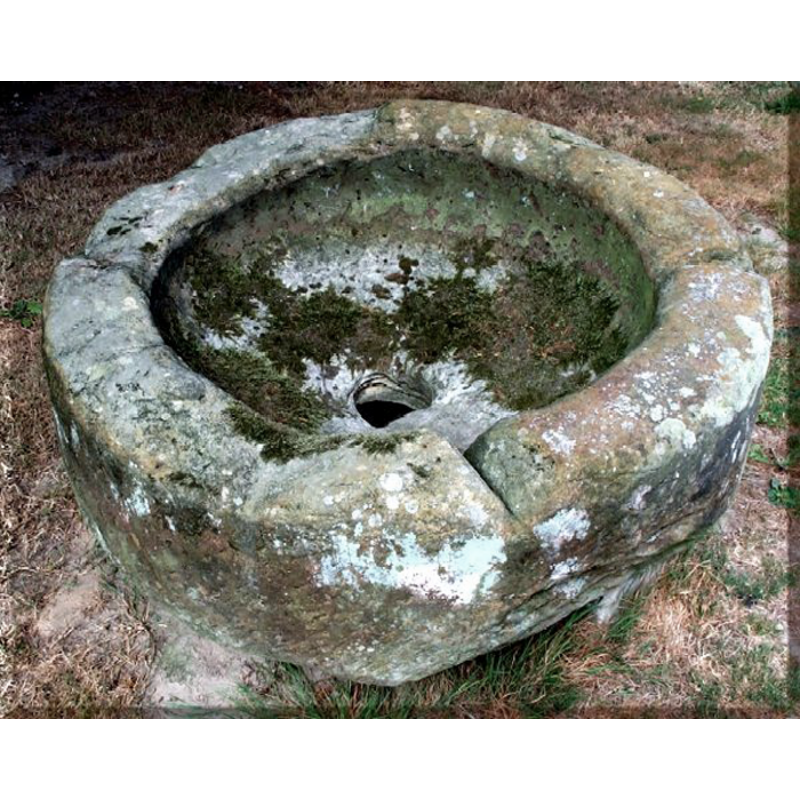
Copyright Statement: Image copyright © Mark Collins, 2003
Image Source: digital photograph taken 22 August 2003 by Mark Collins [www.roughwood.net/ChurchAlbum/ChurchFrames.htm] [accessed 6 February 2013]
Copyright Instructions: Standing permission
view of church exterior - southeast view
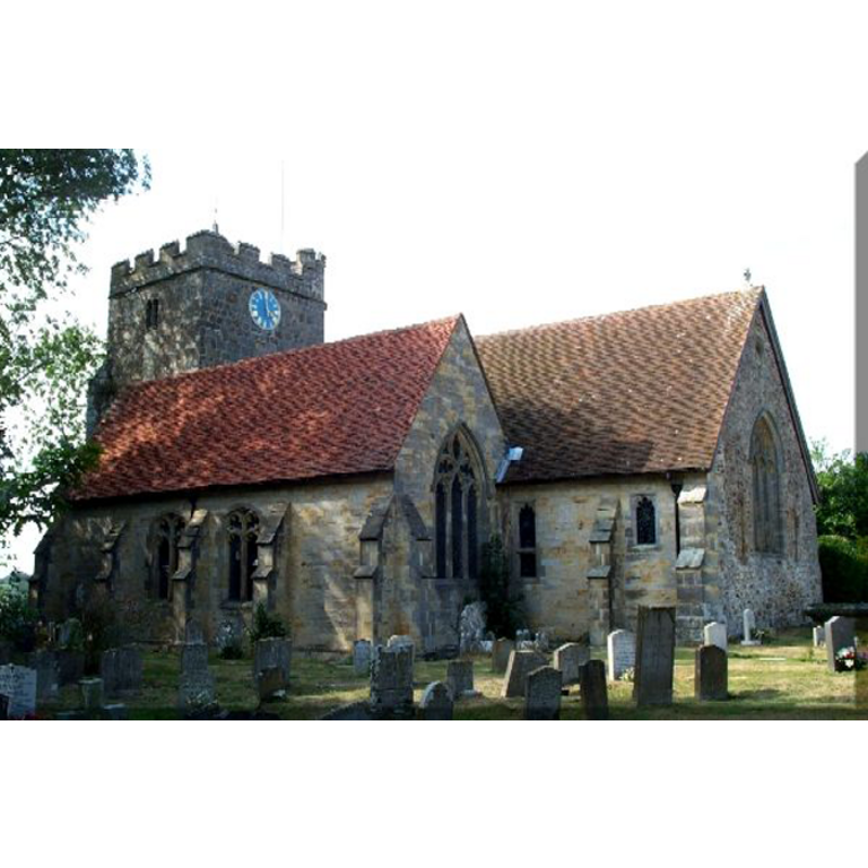
Copyright Statement: Image copyright © Mark Collins, 2003
Image Source: digital photograph taken 22 August 2003 by Mark Collins [www.roughwood.net/ChurchAlbum/ChurchFrames.htm] [accessed 6 February 2013]
Copyright Instructions: Standing permission
view of church interior - nave - looking east
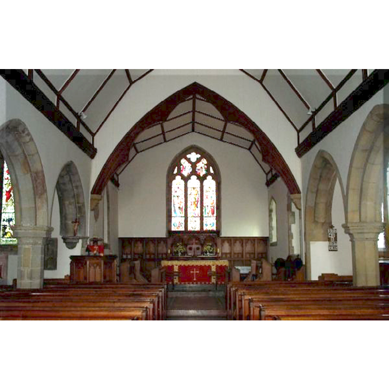
Copyright Statement: Image copyright © Mark Collins, 2003
Image Source: digital photograph taken 22 August 2003 by Mark Collins [www.roughwood.net/ChurchAlbum/ChurchFrames.htm] [accessed 6 February 2013]
Copyright Instructions: Standing permission
view of basin in context

Copyright Statement: Image copyright © CRSBI, 208
Image Source: B&W photograph in the CRSBI [www.crsbi.ac.uk/search/county/site/ed-sx-waldr.html] [accessed 6 February 2013]
Copyright Instructions: PERMISSION NOT AVAILABLE -- IMAGE NOT FOR PUBLIC USE
INFORMATION
Font ID: 18310WAL
Object Type: Baptismal Font1?
Font Century and Period/Style: Medieval
Cognate Fonts: [cf. FontNotes]
Church / Chapel Name: Parish Church of All Saints
Font Location in Church: Outside the N side of the church
Church Patron Saint(s): All Saints
Church Address: Church Street, Heathfield and Waldron, East Sussex TN21 9AQ
Site Location: East Sussex, South East, England, United Kingdom
Ecclesiastic Region: Diocese of Chichester
Historical Region: Hundreds of Shiplake and Dill -- Rape of Pevensey and Laughton
Additional Comments: disused font? / is it a font at all? [cf. FontNotes]
Font Notes:
Click to view
Walker (1908) reports a basin of a font, recently discovered in a nearby farm, with traces of the lead lining on it. Harrison (1920) reports an "old font" in the church that dates to the Early English period. Mee (1964) dates to Saxon times and compares it to those at Bignor and Selham. Described and illustrated in the CRSBI (2008), which cites both Walker and Mee, and adds: "he broad, shallow proportions of this basin are unusual for a Norman font." The Sussex Parish Churches site [www.sussexparishchurches.org/content/view/304/34/] [accessed 6 February 2013] reports two fonts [cf. infra] in this church: the modern is a "C19 square bowl with corner-shafts, said to be a copy of one found in fragments at the restoration"; on the second 'font', the web site remarks: "(Outside north aisle) Tub-font, found c1906 at a local farm in use as a cattle-trough [...]. Its proportions are shallower than most in the C11 and C12 when such fonts were common and there is no certainty that it was a font, let alone from this church. What may be the remnants of inset lead letters have been discerned", and refers to Walker [cf. supra]. The local Star Inn site [www.starinn-waldron.co.uk/about-waldron-links/] [accessed 6 February 2013] notes: "History shows that the village was visited by Cromwell's troops in the mid 1600's and it is said that the troops rolled the font down the nearby hill. This font has been restored to the church and is said to be one of the three great round Saxon fonts in Sussex." The basin appears round and of crude irregular workmanship, rounded underbowl outside and a flat inner well bottom provided with an enlarged drain hole in the centre and a cut in the rim that was probably made by the farmers to use as it a trough, a common happening to fonts that ended up used as farm implements.
Credit and Acknowledgements: We are grateful to Mark Collins, of the Roughwood Brtish Churches Album [www.roughwood.net/ChurchAlbum], for his photographs of church and font
COORDINATES
UTM: 31U 303509 5648153
Latitude & Longitude (Decimal): 50.95145, 0.202458
Latitude & Longitude (DMS): 50° 57′ 5.22″ N, 0° 12′ 8.85″ E
MEDIUM AND MEASUREMENTS
Material: stone
Font Shape: hemispheric
Basin Interior Shape: round
Basin Exterior Shape: round
Drainage System: centre hole in basin
Drainage Notes: [cf. FontNotes]
Rim Thickness: 16.5 cm [calculated]
Diameter (inside rim): 76 cm*
Diameter (includes rim): 109 cm*
Basin Total Height: 32 cm*
Notes on Measurements: * [CRSBI (2008)]
REFERENCES
- Corpus of Romanesque Sculpture in Britain and Ireland, [n.d.].
- Harrison, Frederick, Notes on Sussex churches, Hove: Combridges, 1920, p. 205
- Mee, Arthur, The King's England, Sussex, London: Hodder & Stoughton, 1964, p. 203
- Walker, A.K., An introduction to the study of English fonts, with details of those in Sussex, 1908, p. 58