Rumboldswyke / Rumboldswhyke
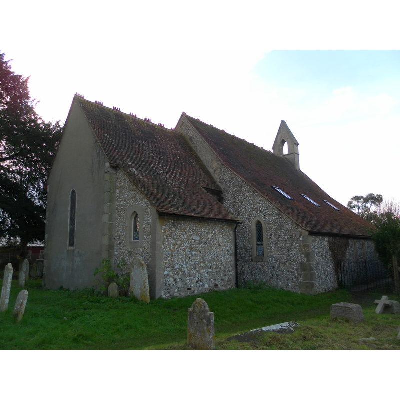
Image copyright © The Voice of Hassocks, 2012
CC-BY-SA-3.0
Results: 1 records
view of church exterior - northeast view
Scene Description: the former church of St. Mary and St. Rumbold, now a commercial building [cf. FontNotes]
Copyright Statement: Image copyright © The Voice of Hassocks, 2012
Image Source: digital photograph taken 28 Janury 2012 by The Voices of Hassocks [http://en.wikipedia.org/wiki/File:Former_St_Mary%27s_Church,_Whyke_Road,_Rumboldswhyke_%28NHLE_Code_1354384%29.JPG] [accessed 19 September 2012]
Copyright Instructions: CC-BY-SA-3.0
INFORMATION
Font ID: 18186RUM
Object Type: Baptismal Font1
Font Century and Period/Style: 11th century, Norman
Church / Chapel Name: Parish Church of St. Mary [redundant since 1994; converted to offices in 2002]
Font Location in Church: [cf. FontNotes]
Church Patron Saint(s): St. Mary the Virgin and/or St. Rumwold [aka Rumbald, Rumbold, Rumwald]
Church Notes: The British Listed Buildings database entry for this former church notes: "restored again in the mid C20, but was made redundant in the late 1970s. It was converted to offices by CMA architects in 2002. " Now the headquarters of HMDW Architects.
Church Address: 50 Whyke Road, Chichester, West Sussex PO19 2JG
Site Location: West Sussex, South East, England, United Kingdom
Directions to Site: Located in the ESE of Chichester
Ecclesiastic Region: [Diocese of Chichester]
Historical Region: Hundred of Box and Stockbridge -- Rape of Chichester -- Sussex
Additional Comments: disappeared font? [cf. FontNotes]
Font Notes:
Click to view
The Victoria County History (Sussex, vol. 4, 1953) notes: "The original church, a chancel and nave, was built in the 11th century, and suffered no more than minor alterations till the 19th. [...] The church is now [i.e., ca.1953] only in occasional use, the regular parish services being held in the modern church of St. George. [...] The font and other fittings [...] are modern. [...] immediately east of the doorway is the trefoil-headed recess of a holy-water stoup of which the basin is missing [...] perhaps 13th-century." The VCH entry (ibid.) includes a 1937 plan of the church interior in which a font appears located in the northwest area of the nave. Green (2008) writes: "When working on the floor of St Mary’s in June 1959 builders unearthed some cut stones, part of the wall that was demolished for the 1866 extension. No sign was found of the medieval font that disappeared about that time." [NB: we have no information on the font of the original 11th-century church here, or any subsequent fonts either; the font noted in the VCH plan was probably 19th-century, and even that one was removed during the redundancy period, whereabouts unknown to us. The church was made redundant in 1994 and 2000, and turned into a commerical building in 2002 [cf. Diocese of Chichester document [www.churchofengland.org/media/56455/chichester.pdf] [accessed 19 September 2012].
COORDINATES
UTM: 30U 657295 5633298
Latitude & Longitude (Decimal): 50.83, -0.7664
Latitude & Longitude (DMS): 50° 49′ 48″ N, 0° 45′ 59.04″ W
REFERENCES
- Victoria County History [online], University of London, 1993-. URL: https://www.british-history.ac.uk.
- Green, Ken, "Whyke, St George with Rumboldswyke, St Mary and Portfield, All Saints, The Parish and its Rectors - Historical Notes", 2008