Gloucester No. 9 / Glouuecestre / Glowecestre
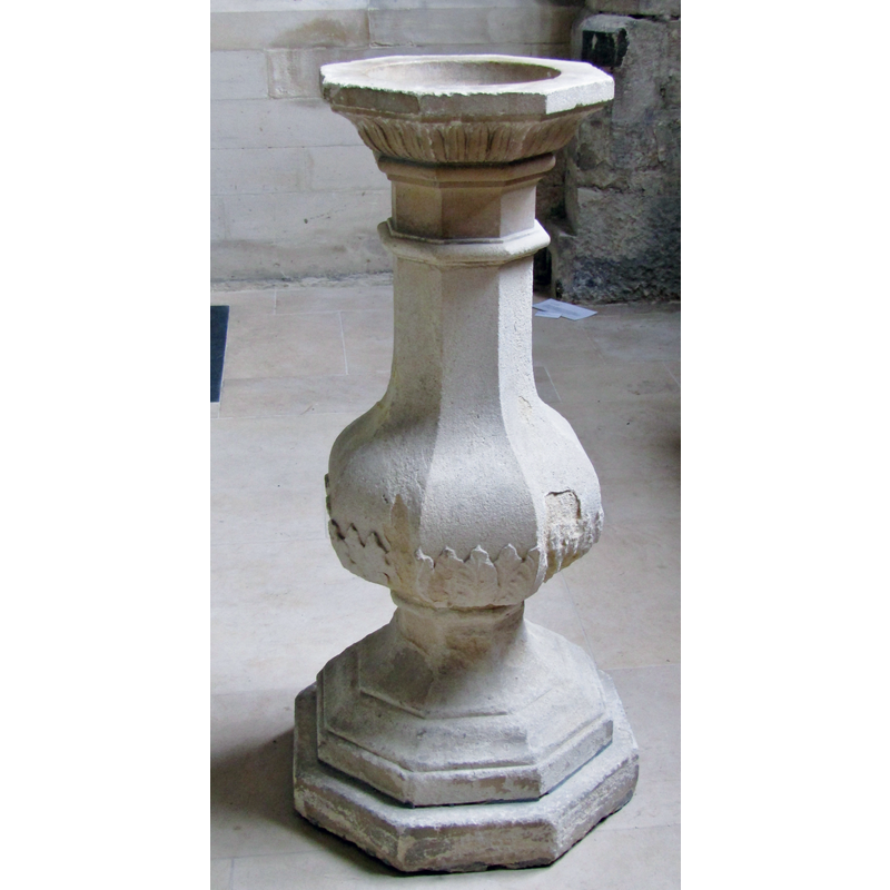
Image copyright © Colin Smith, 2020
Image and permission received from the author (e-mail of 29 March 2020)
Results: 5 records
view of font
Scene Description: the early-18thC font
Copyright Statement: Image copyright © Colin Smith, 2020
Image Source: digital photograph taken in 2019 by Colin Smith
Copyright Instructions: Image and permission received from the author (e-mail of 29 March 2020)
view of church exterior - west portal - tympanum
!["a renewed or re-cut central, semicircular arched doorway, C12 but mostly renewed or re-cut in C19" [cf. FontNotes]](/static-50478a99ec6f36a15d6234548c59f63da52304e5/compressed/1200329037_compressed.png)
Scene Description: "a renewed or re-cut central, semicircular arched doorway, C12 but mostly renewed or re-cut in C19" [cf. FontNotes]
Copyright Statement: Image copyright © Philafrenzy, 2011
Image Source: edited detail of a digital photograph taken 20 August 2011 by Philafrenzy [https://commons.wikimedia.org/wiki/File:St_Mary_de_Crypt_Church,_Gloucester_01.JPG] [accessed 29 March 2020]
Copyright Instructions: CC-BY-SA-4.0
view of church exterior - west portal
!["a renewed or re-cut central, semicircular arched doorway, C12 but mostly renewed or re-cut in C19" [cf. FontNotes]](/static-50478a99ec6f36a15d6234548c59f63da52304e5/compressed/1200329036_compressed.png)
Scene Description: "a renewed or re-cut central, semicircular arched doorway, C12 but mostly renewed or re-cut in C19" [cf. FontNotes]
Copyright Statement: Image copyright © Philafrenzy, 2011
Image Source: edited detail of a digital photograph taken 20 August 2011 by Philafrenzy [https://commons.wikimedia.org/wiki/File:St_Mary_de_Crypt_Church,_Gloucester_03.JPG] [accessed 29 March 2020]
Copyright Instructions: CC-BY-SA-4.0
view of church exterior in context - southwest view
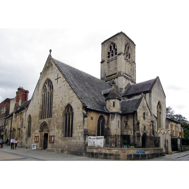
Copyright Statement: Image copyright © Colin Smith, 2020
Image Source: digital photograph taken in 2019 by Colin Smith
Copyright Instructions: Image and permission received from the author (e-mail of 29 March 2020)
view of font in context
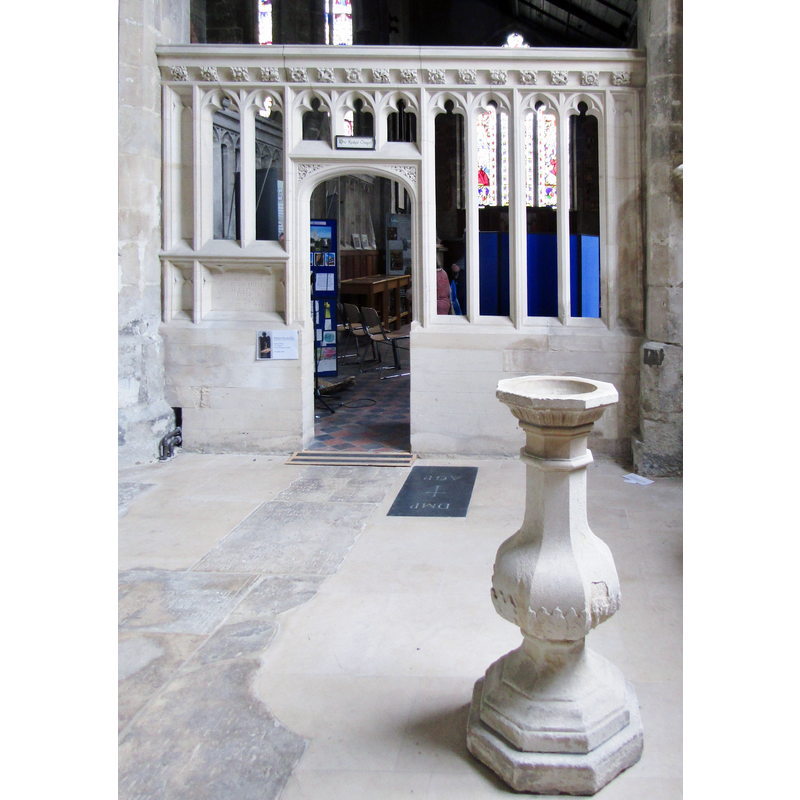
Scene Description: the early-18thC font
Copyright Statement: Image copyright © Colin Smith, 2020
Image Source: digital photograph taken in 2019 by Colin Smith
Copyright Instructions: Image and permission received from the author (e-mail of 29 March 2020)
INFORMATION
Font ID: 18086GLO
Object Type: Baptismal Font1?
Font Date: ca. 1140?
Font Century and Period/Style: 12th century, Late Norman
Church / Chapel Name: Church of St. Mary de Crypt with All Saints and St Owen [aka St. Mary in the South / Christ Church / Church of the Blessed Mary within Southgate]
Church Patron Saint(s): St. Mary the Virgin [with All Saints & St. Owen]
Church Notes: original church documented ca. 1140; much re-built since
Church Address: Southgate St, Gloucester GL1 1TP, UK
Site Location: Gloucestershire, South West, England, United Kingdom
Directions to Site: Located on Southgate St in central Gloucester. Gloucester is located off (W) the A430, on Northgate St, 9-10 km WSW of Cheltenham and the M5
Ecclesiastic Region: Diocese of Gloucester
Historical Region: Hundred of Dudstone
Additional Comments: disappeared font? (the one from the ca. 1140 medieval church here)
Font Notes:
Click to view
There are five entries for Gloucester [variant spellings] in the Domesday survey [https://opendomesday.org/place/SO8318/gloucester/] [accessed 12 April 2020] none of which mentions priest or church in it. The Victoria County History (Gloucester, vol. 4, 1988) notes: "The church, in Southgate Street, was recorded from the early 1140s. [...] It was usually known as St. Mary in the south until the mid 16th century when a crypt served to distinguish it by name. [...] Between the 15th and 17th centuries it was also called Christ Church. [...] The only fragment of the 12th-century church to survive is the hoodmould of the west doorway. [...] The church has [...] an early 18th-century font. The entry for this church in Historic England [Listing NGR: SO8308118419] notes: "Parish church. First recorded c1140. Mainly C14, late C15 and early C16 incorporating some C12 and C13 structure and features. Extensive restoration, 1844-5, by S. W. Daukes and J. R. Hamilton, further restoration in 1866, 1876, 1903, and 1908 [...] the west front facing street has a steeply pitched gable-end wall to nave and aisles, a renewed or re-cut central, semicircular arched doorway, C12 but mostly renewed or re-cut in C19 [...] early C18 stone baluster form font". [NB: we have no information on the font from the medieval church here].
COORDINATES
UTM: 30U 551843 5746191
Latitude & Longitude (Decimal): 51.8641, -2.2471
Latitude & Longitude (DMS): 51° 51′ 50.76″ N, 2° 14′ 49.56″ W
REFERENCES
- Victoria County History [online], University of London, 1993-. URL: https://www.british-history.ac.uk.