Oxford No. 26 / Oxeneford
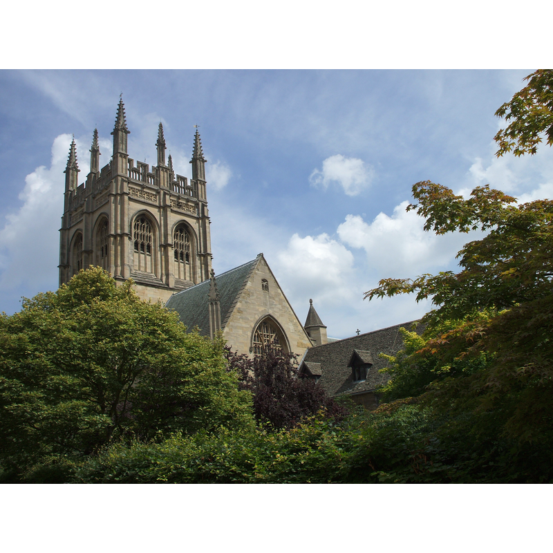
Image copyright © Ozeye, 2009
CC-BY-SA-3.0
Results: 3 records
BH01: human figure - head - wearing headdress
![detail of the 19th-century font [cf. FontNotes]](/static-50478a99ec6f36a15d6234548c59f63da52304e5/others/permission_not_available.jpg)
Scene Description: detail of the 19th-century font [cf. FontNotes]
Copyright Statement: Image copyright © hpwtdogmom [Andrea Loughry], 2009
Image Source: digital photograph taken 26 April 2009 by hpwtdogmom [Andrea Loughry] [www.flickr.com/photos/hpwtdogmom/4434544182/] [accessed 19 June 2012]
Copyright Instructions: PERMISSION NOT AVAILABLE -- IMAGE NOT FOR PUBLIC USE
view of church - elevation - tower
Copyright Statement: Image copyright © Ozeye, 2009
Image Source: digital photograph taken 28 June 2009 by Ozeye [http://en.wikipedia.org/wiki/File:Merton_College_Chapel_from_just_north_of_the_Meadow.jpg] [accessed 19 June 2012]
Copyright Instructions: CC-BY-SA-3.0
view of font cover - detail
Scene Description: detail of the 19th-century font cover [cf. FontNotes]
Copyright Statement: Image copyright © hpwtdogmom [Andrea Loughry], 2009
Image Source: digital photograph taken 26 April 2009 by hpwtdogmom [Andrea Loughry] [www.flickr.com/photos/hpwtdogmom/4433770381/] [accessed 19 June 2012]
Copyright Instructions: PERMISSION NOT AVAILABLE -- IMAGE NOT FOR PUBLIC USE
INFORMATION
Font ID: 18076OXF
Object Type: Baptismal Font1?
Font Century and Period/Style: Medieval
Church / Chapel Name: Merton College Chapel [aka Church or Chapel of St. Mary and St. John]
Church Patron Saint(s): St. Mary the Virgin & St. John the Baptist
Church Address: Merton Street , Oxford OX1 4JD
Site Location: Oxfordshire, South East, England, United Kingdom
Directions to Site: Located inside the College, on Merton Street, central Oxford
Ecclesiastic Region: Diocese of Oxford
Historical Region: Hundred of Headington
Additional Comments: disappeared font? (was there a font in this chapel from early times?
Font Notes:
Click to view
There are thirteen entries for Oxford [variant spelling] in the Domesday survey [http://opendomesday.org/place/SP5106/oxford/] [accessed 10 November 2016]; two of them mentions a church in each. The brief history of this chapel appears in the Merton College web site [www.merton.ox.ac.uk/chapel_and_choir/history.shtml] [accessed 19 June 2012]: "Work on the church of St Mary and St John, now the Quire of Merton College Chapel, started in the late 1280s to replace the parish church of St John the Baptist which stood on the site now occupied by the north wing of Mob Quad. [...] By the end of the century the Crossing and South Transept had been built, followed in 1425 by the North Transept. This space was designated for the use of parishioners, accounting for the ability to enter the Chapel from the street. [...] The Chapel was never completed [...] The nineteenth century saw extensive changes to the Chapel interior. [...] a gothic font was introduced to the North Transept". [NB: we have no information on any earlier fonts in this chapel].
COORDINATES
UTM: 30U 620654 5734797
Latitude & Longitude (Decimal): 51.751062, -1.252109
Latitude & Longitude (DMS): 51° 45′ 3.82″ N, 1° 15′ 7.59″ W
REFERENCES
- Victoria County History [online], University of London, 1993-. URL: https://www.british-history.ac.uk.