Hartwell nr. Northampton
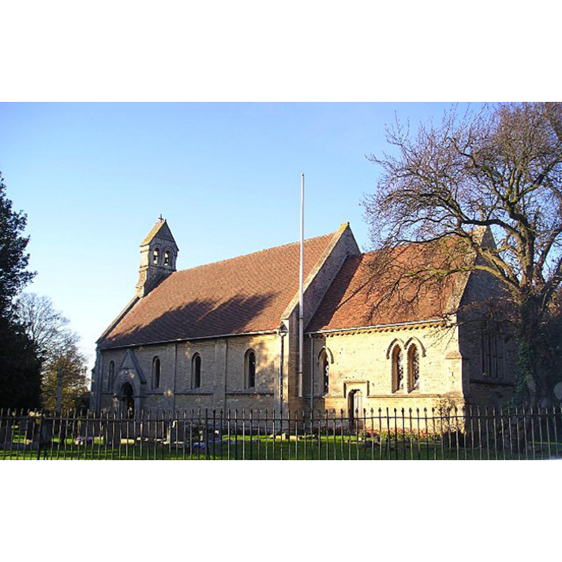
Image copyright © John Eggins, 2005
CC-BY-SA-3.0
Results: 2 records
view of church exterior - southeast view
Scene Description: the new church [cf. FontNotes]
Copyright Statement: Image copyright © John Eggins, 2005
Image Source: digital photograph taken 18 November 2005 by John Eggins [www.geograph.org.uk/photo/81642] [accessed 5 July 2012]
Copyright Instructions: CC-BY-SA-3.0
view of font and cover
![the modern font and cover in the new church [cf. FontNotes]](/static-50478a99ec6f36a15d6234548c59f63da52304e5/others/permission_not_available.jpg)
Scene Description: the modern font and cover in the new church [cf. FontNotes]
Copyright Statement: Image copyright © Norfolk12, 2012
Image Source: digital photograph taken by Norfolk12 [www.waymarking.com/waymarks/WMBCTG_Hartwell_Church_of_St_John_the_Baptist] [accessed 5 June 2012]
Copyright Instructions: PERMISSION NOT AVAILABLE -- IMAGE NOT FOR PUBLIC USE
INFORMATION
Font ID: 18054HAR
Object Type: Baptismal Font1
Font Century and Period/Style: Norman
Church / Chapel Name: Parish Church of St. John the Baptist
Font Location in Church: [cf. FontNotes]
Church Patron Saint(s): St. John the Baptist
Church Address: Ashton Road, Hartwell, Northamptonshire, NN7 2HU
Site Location: Northamptonshire, East Midlands, England, United Kingdom
Directions to Site: Located off the M1, near Salcey Forest, 11 km S of Northampton, 20 km N of Milton Keynes
Ecclesiastic Region: Diocese of Peterborough
Historical Region: Hundred of Cleley
Additional Comments: disappeared font? (the original Norman font noted in Baker)
Font Notes:
Click to view
A Norman font in this church is reported in Baker (1822-1841) [cf. infra]. The Victoria County History (Northampton, vol. 5, 2002) notes: "There was a priest on the bishop of Bayeux's fee in Hartwell in 1086 [...] The chapel, dedicated to St. John the Baptist, stood in the middle of the deserted village whose site is represented today by Chapel Farm, [...] and remained in use after the settlement itself was reduced to a single farm." The VCH (ibid.) further notes that "By the time Baker was writing, the aisle had been taken down and the arches dividing it from the nave and chancel bricked up. There was no division between nave and chancel. He described the main south door, a blocked doorway in the south wall leading to the chancel, the four nave arches, and the plain circular font as all clearly Norman." [footnoted to Baker, Northants., ii. 186-7]. In its description of the new church the VCH (ibid.) notes it was erected in 1851 "in the centre of the modern village", but there is no mention of the earlier or a later font in it. The font in the new church is of neo-Romanesque design, cylindrical and monolithic, decorated with a rope moulding at the upper rim, and a blank arcade of intersecting round arches around the sides. The wooden cover, also modern, is octagonal, with a cross finial/handle.
COORDINATES
UTM: 30U 646820 5779484
Latitude & Longitude (Decimal): 52.14632, -0.854215
Latitude & Longitude (DMS): 52° 8′ 46.75″ N, 0° 51′ 15.17″ W
REFERENCES
- Victoria County History [online], University of London, 1993-. URL: https://www.british-history.ac.uk.
- Baker, George, The History and Antiquities of the County of Northampton, London: J.B. Nichols, 1822-1841, vol. 2: 186-187