Durham No. 8 / Clayport Gate
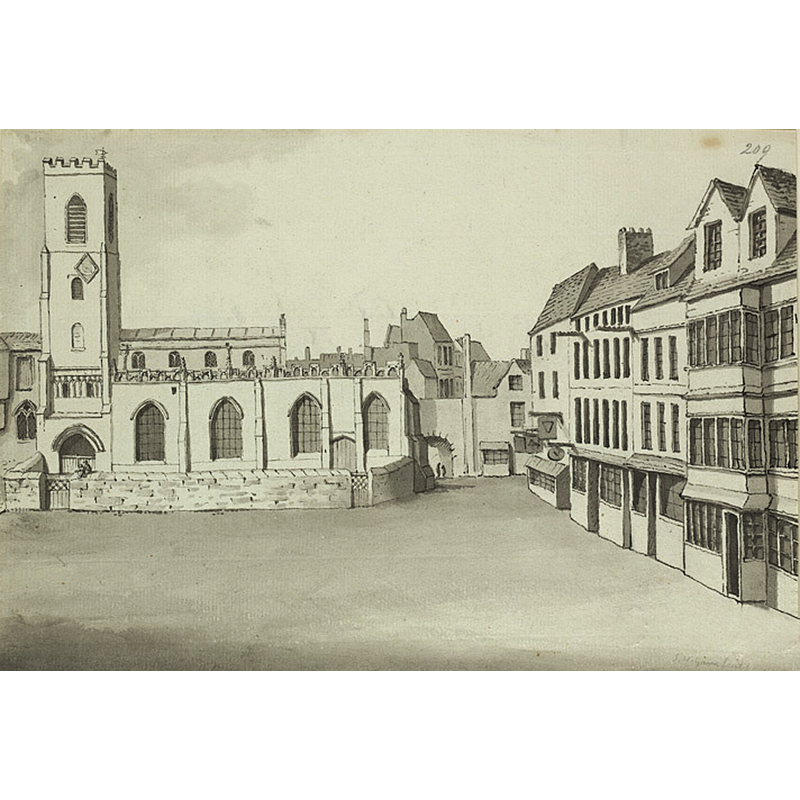
Image copyright © [in the public domain]
posted as PD
Results: 1 records
view of church exterior - south view
Scene Description: the now disappeared old church
Copyright Statement: Image copyright © [in the public domain]
Image Source: drawing by Samuel Hieronymus Grimm (1733-1794) in Wikipedia [http://en.wikipedia.org/wiki/File:Old_St_Nicholas_Durham.jpg] [accessed 23 December 2011]
Copyright Instructions: posted as PD
INFORMATION
Font ID: 17811DUR
Object Type: Baptismal Font1
Font Century and Period/Style: 12th century, Medieval
Church / Chapel Name: Old Parish Church [demolished in 1791 (?) and replaced by St. Nicholas' Church]
Church Patron Saint(s): St. Nicholas
Church Address: [the old church was located at Clayport Gate -- the new church is at: The Market Place, Durham, County Durham, DH1 3NJ]
Site Location: Durham, North East, England, United Kingdom
Ecclesiastic Region: Diocese of Durham
Additional Comments: disappeared font? (the medieval one)
Font Notes:
Click to view
The Victoria County History (Durham, vol. 3, 1928) reports that Sir Stephen Glynne visited the previous church in 1825 and described it as : "a large structure displaying some marks of antiquity although the barbarous hand of innovation has swept nearly all before it." [cited in the VCH entry with source: "Proc. Soc. Antiq. Newcastle (3rd ser.), iii, 283."]; the VCH further reports that "building pulled down in 1857". The Parish of St. Nicholas web site [www.stnics.org.uk/who_we_are/church_guide/the_fonts/] [accessed 23 December 2011] informs: "St Nicholas has two fonts - one usually stands just inside the entrance, the other on the left-hand side of the chancel arch. They make an instructive contrast. One is clearly very old, some think it may be the oldest object in the building. The other was made at the time of the 1980 restoration. The old font was removed from the old church when it was pulled down in 1857. It passed through several hands into the possession of one Matthew Fowler MP, in whose garden it stood for some time. When dying in 1898 he directed it to be restored to the custody of the vicar and wardens. It came home in 1904. The font bears the date 1700 and part of an inscription . . ."ChW..." perhaps a portion of the word 'Church Warden'." The font dated 1700 is located at the west end of the south aisle, and consists of a round basin decorated with ribbed or gadrooned pattern, raised on a moulded stem and circular base. [NB: the old church may date back to the 12th century, but we have no information on its medieval font].
COORDINATES
UTM: 30U 591638 6070963
Latitude & Longitude (Decimal): 54.7775, -1.575278
Latitude & Longitude (DMS): 54° 46′ 39″ N, 1° 34′ 31″ W
REFERENCES
- Victoria County History [online], University of London, 1993-. URL: https://www.british-history.ac.uk.