Swallowfield / Soanesfelt / Solafel / Sualesfelle / Swalewefild / Swallfelde
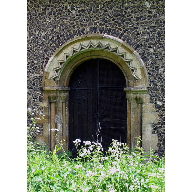
Image copyright © John Salmon, 2005
CC-BY-SA-2.0
Results: 3 records
view of church exterior - north portal
Copyright Statement: Image copyright © John Salmon, 2005
Image Source: digital photograph taken 21 May 2005 by John Salmon [www.geograph.org.uk/photo/331151] [accessed 26 March 2015]
Copyright Instructions: CC-BY-SA-2.0
view of church exterior - northwest view
![Source caption: "Historical records state that this church was erected by John le Despenser around 1256. However the north doorway, seen here [...] is built in a style that was in use about a hundred years previously, suggesting that a religious building existed before the mid 13th century. It is possible that the chancel and nave were originally of a late 12th century date and were lengthened at the later date. The brick and timber bell turret is a much more recent structure and contains three unusual almost trefoiled windows."](/static-50478a99ec6f36a15d6234548c59f63da52304e5/compressed/1150327020_compressed.png)
Scene Description: Source caption: "Historical records state that this church was erected by John le Despenser around 1256. However the north doorway, seen here [...] is built in a style that was in use about a hundred years previously, suggesting that a religious building existed before the mid 13th century. It is possible that the chancel and nave were originally of a late 12th century date and were lengthened at the later date. The brick and timber bell turret is a much more recent structure and contains three unusual almost trefoiled windows."
Copyright Statement: Image copyright © Nigel Cox, 2008
Image Source: digital photograph taken 19 November 2008 by Nigel Cox [www.geograph.org.uk/photo/1055971] [accessed 26 March 2015]
Copyright Instructions: CC-BY-SA-2.0
view of church interior - nave - looking east
![partially showing the modern baptismal font in the foreground [west end], left [north] side](/static-50478a99ec6f36a15d6234548c59f63da52304e5/compressed/1150327022_compressed.png)
Scene Description: partially showing the modern baptismal font in the foreground [west end], left [north] side
Copyright Statement: Image copyright © John Salmon, 2005
Image Source: digital photograph taken 21 May 2005 by John Salmon [www.geograph.org.uk/photo/331147] [accessed 26 March 2015]
Copyright Instructions: CC-BY-SA-2.0
INFORMATION
Font ID: 17760SWA
Object Type: Baptismal Font1?
Font Century and Period/Style: 12th - 13th century, Medieval
Church / Chapel Name: Parish Church of All Saints
Church Patron Saint(s): All Saints
Church Address: Church Road, Swallowfield, Berkshire, RG7 1TJ
Site Location: Berkshire, South East, England, United Kingdom
Directions to Site: Located off (W) the A33, 8 km S of Reading, just N of the county border with Hampshire
Ecclesiastic Region: Diocese of Oxford
Historical Region: Hundred of Charldon [in Domesday] -- Hundred of Charlton
Additional Comments: dissappeared font? (the original font here?)
Font Notes:
Click to view
There are three entries for Swallowfield [ in the Domesday survey [http://domesdaymap.co.uk/place/SU7164/swallowfield/] [accessed 26 March 2015], but neither mentions cleric or church in it. The Victoria County History (Berkshire, vol. 3, 1923) notes: "This church is said to have been erected by John le Despenser (lord of Beaumys) about the middle of the 13th century, but the 12th-century detail of the north doorway shows that a building existed before that period. It is probable that the chancel and nave were originally of late 12th-century date and were lengthened at the later date. [...] The octagonal stone font is modern." [NB: we have no information on the medieval font here].
COORDINATES
UTM: 30U 642654 5693805
Latitude & Longitude (Decimal): 51.377549, -0.950235
Latitude & Longitude (DMS): 51° 22′ 39.17″ N, 0° 57′ 0.85″ W
REFERENCES
- Victoria County History [online], University of London, 1993-. URL: https://www.british-history.ac.uk.