Shellingford / Salingeford / Sallingford / Scaringaford / Schalingeford / Schillingford / Serengeford / Shallingford / Shillingford / Shillingworth
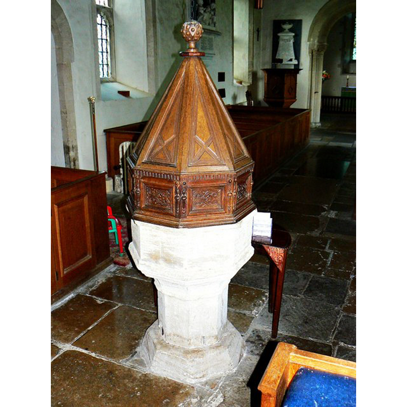
Image copyright © Brian Robert Marshall, 2012
CC-BY-SA-2.0
Results: 10 records
view of font and cover
Scene Description: Source caption: "The octagonal font is 15th century with a Jacobean cover."
Copyright Statement: Image copyright © Brian Robert Marshall, 2012
Image Source: digital photograph taken 17 Juky 2012 by Brian Robert Marshall [www.geograph.org.uk/photo/3043667] [accessed 4 June 2015]
Copyright Instructions: CC-BY-SA-2.0
design element - motifs - moulding
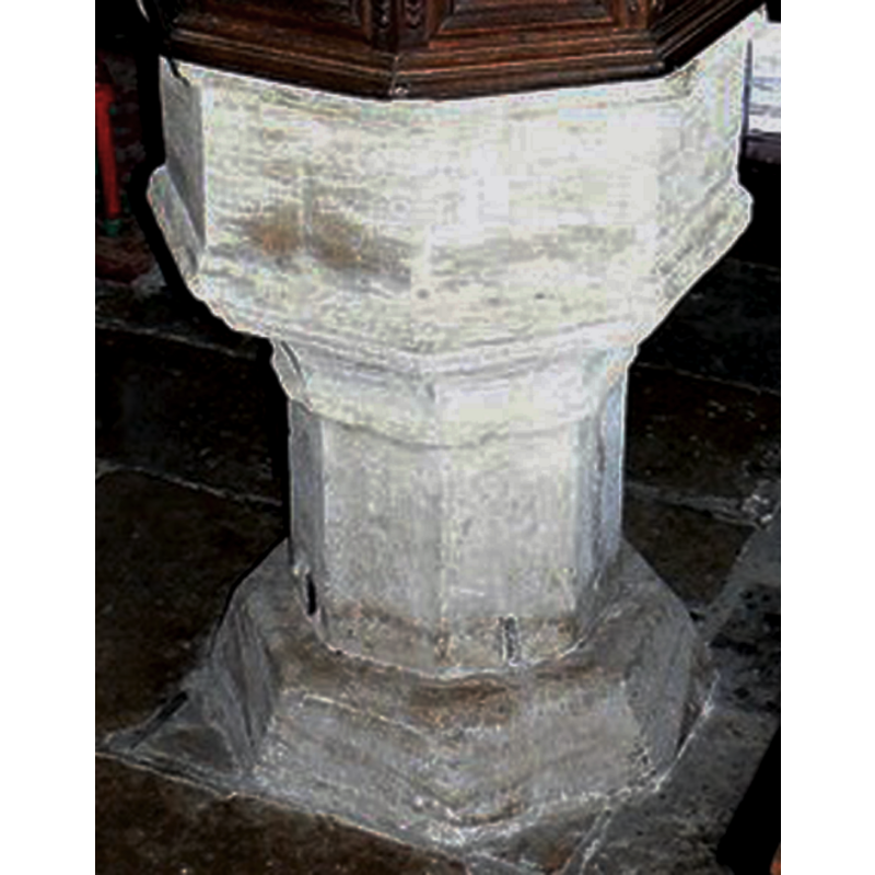
Copyright Statement: Image copyright © Brian Robert Marshall, 2012
Image Source: detail of a digital photograph taken 17 Juky 2012 by Brian Robert Marshall [www.geograph.org.uk/photo/3043667] [accessed 4 June 2015]
Copyright Instructions: CC-BY-SA-2.0
design element - motifs - moulding
Copyright Statement: Image copyright © Brian Robert Marshall, 2012
Image Source: detail of a digital photograph taken 17 Juky 2012 by Brian Robert Marshall [www.geograph.org.uk/photo/3043667] [accessed 4 June 2015]
Copyright Instructions: CC-BY-SA-2.0
view of church exterior - south portal - chancel portal
![Source caption: "Chancel door [...] The doorway is part of the original 12th century church and is typical of that period. Inside it is covered by a curtain."](/static-50478a99ec6f36a15d6234548c59f63da52304e5/compressed/1150620060_compressed.png)
Scene Description: Source caption: "Chancel door [...] The doorway is part of the original 12th century church and is typical of that period. Inside it is covered by a curtain."
Copyright Statement: Image copyright © Brian Robert Marshall, 2012
Image Source: digital photograph taken 17 July 2012 by Brian Robert Marshall [www.geograph.org.uk/photo/3044812] [accessed 4 June 2015]
Copyright Instructions: CC-BY-SA-2.0
view of church exterior - southwest view
![Source caption: "The rather austere 12th century church is listed Grade I [...] The tower was added in the 13th century with the spire being added in 1625. The spire was struck by lightning in 1852 and was rebuilt. However, the pinnacle of the spire subsequently decayed and was replaced with a glass-fibre pinnacle in 1968."
Source caption: "The octagonal font is 15th century with a Jacobean cover."](/static-50478a99ec6f36a15d6234548c59f63da52304e5/compressed/1150620059_compressed.png)
Scene Description: Source caption: "The rather austere 12th century church is listed Grade I [...] The tower was added in the 13th century with the spire being added in 1625. The spire was struck by lightning in 1852 and was rebuilt. However, the pinnacle of the spire subsequently decayed and was replaced with a glass-fibre pinnacle in 1968."
Source caption: "The octagonal font is 15th century with a Jacobean cover."
Copyright Statement: Image copyright © Brian Robert Marshall, 2012
Image Source: digital photograph taken 17 July 2012 by Brian Robert Marshall [www.geograph.org.uk/photo/3043963] [accessed 4 June 2015]
Copyright Instructions: CC-BY-SA-2.0
view of church interior - nave - looking west
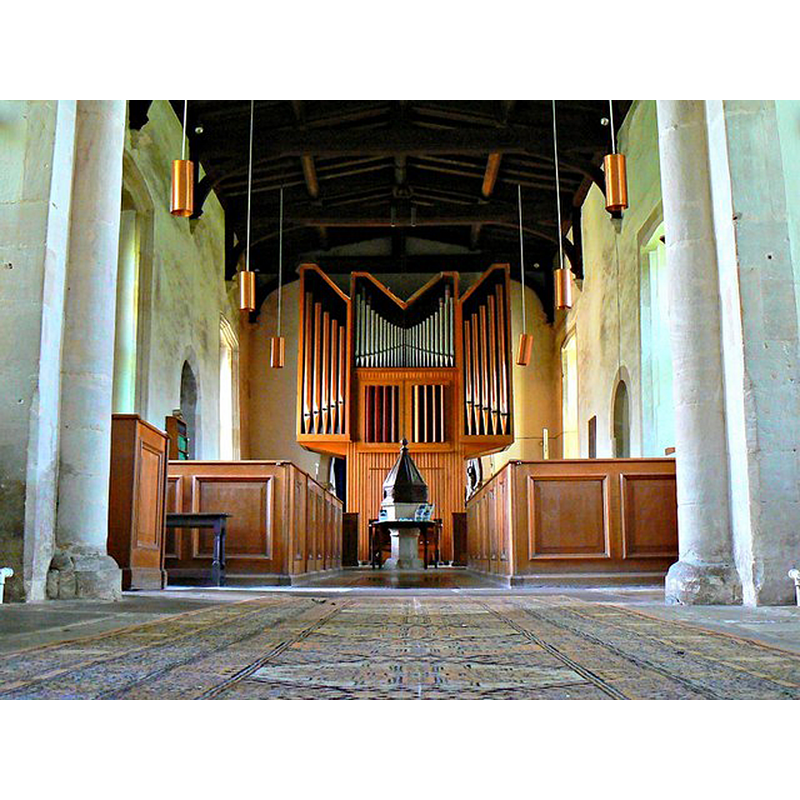
Scene Description: Source caption: "This is a view west from the chancel of the 12th century church. The baroque organ is of recent origin having been gifted to the church in 1968. The light fittings are of about the same age. The half-box pews date to restoration carried out in the 1940s."
Copyright Statement: Image copyright © Brian Robert Marshall, 2012
Image Source: digital photograph taken 17 July 2012 by Brian Robert Marshall [www.geograph.org.uk/photo/3043670] [accessed 4 June 2015]
Copyright Instructions: CC-BY-SA-2.0
view of church interior - nave - looking east
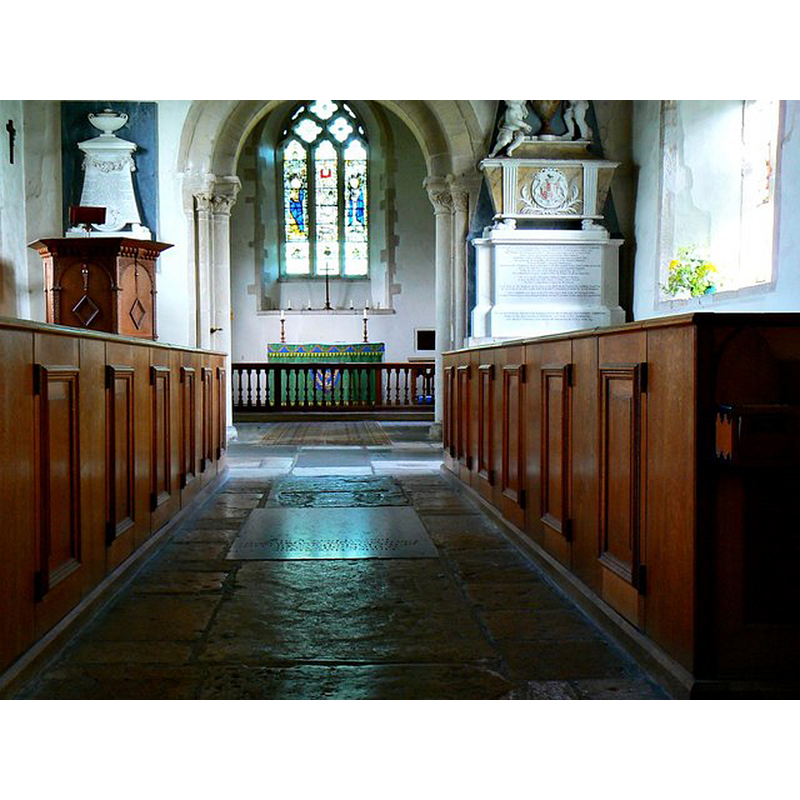
Scene Description: Source caption: "This is a view east towards the chancel. The church dates to the 12th century with later additions. There are monuments within to locally-revered nobles and gentlefolk. The pulpit is early 17th century."
Copyright Statement: Image copyright © Brian Robert Marshall, 2012
Image Source: digital photograph taken 17 July 2012 by Brian Robert Marshall [www.geograph.org.uk/photo/3044812] [accessed 4 June 2015]
Copyright Instructions: CC-BY-SA-2.0
view of font and cover in context
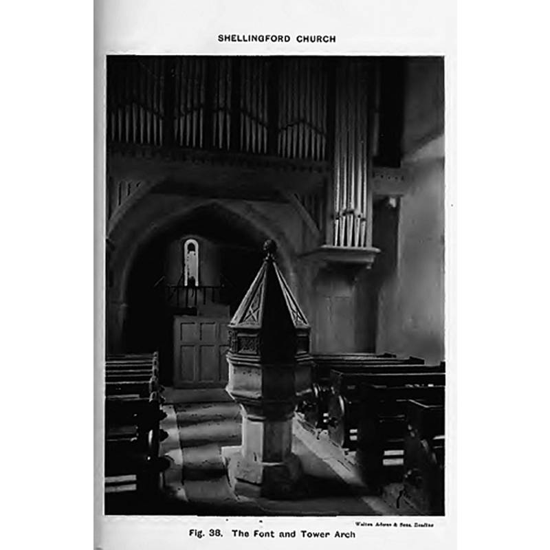
Scene Description: the font and cover in the context of the west end of the nave
Copyright Statement: Image copyright © [in the public domain]
Image Source: B&W photograph by Walton Adams & Sons, Reading, in Keyser (1914)
Copyright Instructions: PD
view of font cover
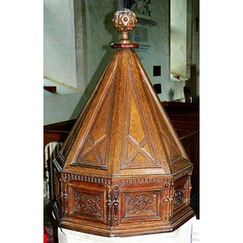
Copyright Statement: Image copyright © Brian Robert Marshall, 2012
Image Source: detail of a digital photograph taken 17 Juky 2012 by Brian Robert Marshall [www.geograph.org.uk/photo/3043667] [accessed 4 June 2015]
Copyright Instructions: CC-BY-SA-2.0
design element - motifs - moulding
Copyright Statement: Image copyright © Brian Robert Marshall, 2012
Image Source: detail of a digital photograph taken 17 Juky 2012 by Brian Robert Marshall [www.geograph.org.uk/photo/3043667] [accessed 4 June 2015]
Copyright Instructions: CC-BY-SA-2.0
INFORMATION
Font ID: 17723SHE
Object Type: Baptismal Font1
Font Century and Period/Style: 15th century, Perpendicular
Church / Chapel Name: Parish Church of St. Faith [aka St. Luke's]
Font Location in Church: Inside the church, at the W end of the nave
Church Patron Saint(s): St. Faith [aka Faith of Conques, Foy]
Church Address: Church Street, Shellingford, Oxfordshire, SN7 7PZ
Site Location: Oxfordshire, South East, England, United Kingdom
Directions to Site: Located 4-5 km SE of Gt. Faringdon [not to be mistaken with a 'Shillingford' in Oxon.
Ecclesiastic Region: Diocese of Oxford
Historical Region: formerly in Berkshire -- Hundred of Ganfield
Additional Comments: disappeared font? (the one from the 12thC church here)
Font Notes:
Click to view
There is an entry for Shellingford [variant spelling] in the Domesday survey [http://opendomesday.org/place/SU3193/shellingford/] [accessed 4 June 2015], but it mentions neither cleric nor church in it. A font here is noted and illustrated in Keyser (1914): "Shellingford Church [...] seems to have been erected towards the end of the 12th century, and the walls are mainly of this date [...] The font has a plain octagonal bowl and stem. It is of 15th century date. It has a very nicely carved Jacobean cover." The basin has mouldings at both ends, and there is another moulding where the underbowl meets the plain octagonal stem. The wooden cover has an octagonal base with carved panels, and an upper pyramidal part, also octagonal with carved sides; ball finial. The Victoria County History (Berkshire, vol. 4, 1924) notes: "The first mention of a church in Shellingford is in 1248 [...] The nave and chancel appear to have been built late in the 12th century", and the first register of baptisms in the church dates to 1579; the VCH entry does not mention a font. [NB: we have no information on the font of the 12th-century church here].
COORDINATES
UTM: 30U 601001 5721942
Latitude & Longitude (Decimal): 51.639405, -1.540432
Latitude & Longitude (DMS): 51° 38′ 21.86″ N, 1° 32′ 25.55″ W
MEDIUM AND MEASUREMENTS
Material: stone
Font Shape: octagonal, mounted
Basin Interior Shape: round
Basin Exterior Shape: octagonal
LID INFORMATION
Date: 17th-century? / Jacobean?
Material: wood, oak?
Apparatus: no
Notes: [cf. FontNotes]
REFERENCES
- Victoria County History [online], University of London, 1993-. URL: https://www.british-history.ac.uk.
- Kempthorne, G.A., Captain, "Sandhurst, Berks.", 20, No.1 (1914), Berks, Bucks & Oxon Archaeological Journal, 1914, pp. 21-25; p. 71 and fig. 38