Maulden / Meldone
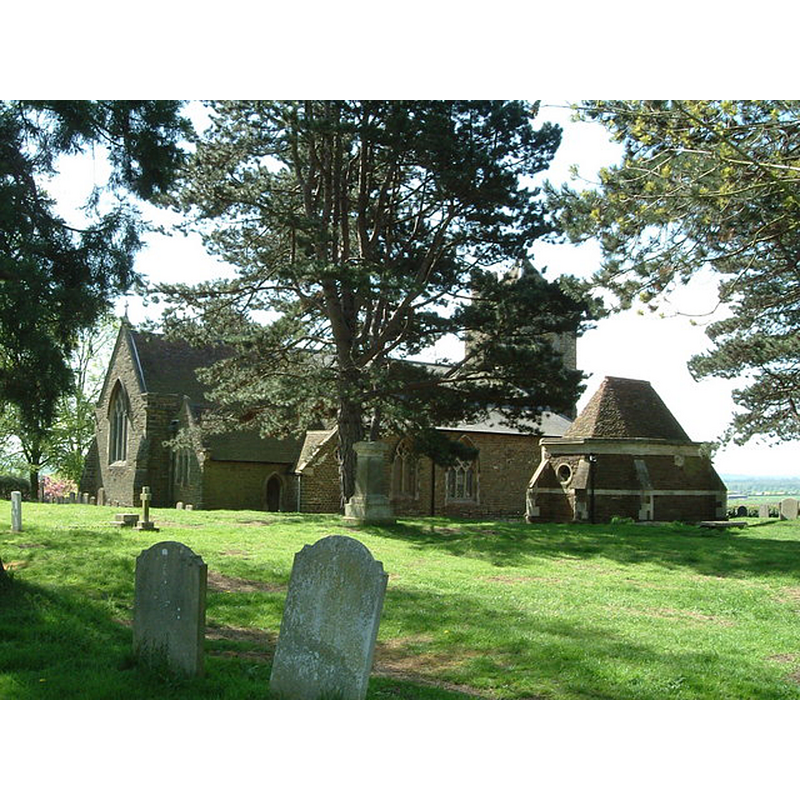
Image copyright © Rob Farrow, 2006
CC-BY-SA-2.0
Results: 3 records
view of church exterior - northeast view
Scene Description: Source caption: "St. Mary the Virgin, Maulden. This is a far more substantial church than it seems at first sight. The tower is only quite small but it has side aisles and other additions. It also has the curious detached building seen here on the right, which is the Ailesbury family mausoleum."
Copyright Statement: Image copyright © Rob Farrow, 2006
Image Source: digital photograph taken 5 May 2006 by Rob Farrow [www.geograph.org.uk/photo/164458] [accessed 18 September 2015]
Copyright Instructions: CC-BY-SA-2.0
view of font and cover

Scene Description: the modern font with an older cover
Copyright Statement: Image copyright © Waymarking.com, 2011
Image Source: digital photograph [www.waymarking.com/waymarks/WMCN7X] [accessed 19 October 2011]
Copyright Instructions: PERMISSION NOT AVAILABLE -- IMAGE NOT FOR PUBLIC USE
view of font cover
Scene Description: [cf. FontNotes]
Copyright Statement: Image copyright © Waymarking.com, 2011
Image Source: detail of a digital photograph [www.waymarking.com/waymarks/WMCN7X] [accessed 19 October 2011]
Copyright Instructions: PERMISSION NOT AVAILABLE -- IMAGE NOT FOR PUBLIC USE
INFORMATION
Font ID: 17689MAU
Object Type: Baptismal Font1?
Font Century and Period/Style: 13th century, Early English
Church / Chapel Name: Parish Church of St. Mary the Virgin
Church Patron Saint(s): St. Mary the Virgin
Church Notes: tour of the church with images of the modern font at www.stmarysmaulden.org/tour.htm [accessed 18 September 2015]
Church Address: Church Road, Maulden, Bedfordshire, MK45 2AU
Site Location: Bedfordshire, East, England, United Kingdom
Directions to Site: Located 2-3 km W of Ampthill, 13 km S of Bedford
Ecclesiastic Region: Diocese of St. Albans
Historical Region: Hundred of Redbornestoke
Additional Comments: disappeared font (the one from the 12thC church here)
Font Notes:
Click to view
There are five entries for Maulden [variant spelling] in the Domesday survey [http://opendomesday.org/place/TL0538/maulden/] [accessed 18 September 2015], none of which mentions cleric or church in it. The Victoria County History (Bedfordshire, vol. 3, 1912) notes: "The value of this church in 1291 was £4 13s. 4d., [...] and at the Dissolution £15 9s. 6d. [...] the lower part of the tower is 14th-century work"; the VCH entry does not mention a font in it. The present font, an octagonal basin with Biblical scenes on the sides, raised on a columnar base, is modern, probably Victorian. The wooden cover, however, could be significantly older than the present font; it appears to be of a fairly common 17th-century design, and may have been the cover of an earlier font; it otherwise could be a 19th-century cover based on an earlier design [NB: we have no information on the font of the medieval church here].
COORDINATES
UTM: 30U 674293 5767459
Latitude & Longitude (Decimal): 52.030329, -0.459231
Latitude & Longitude (DMS): 52° 1′ 49.18″ N, 0° 27′ 33.23″ W
LID INFORMATION
Date: 17th-century?
Material: wood, oak
Notes: [cf. FontNotes]
REFERENCES
- Victoria County History [online], University of London, 1993-. URL: https://www.british-history.ac.uk.