Knotting / Chenotinga / Cnottinge / Knottinge / Knottyngges / Nottinge
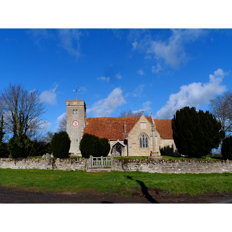
Image copyright © Bikeboy, 2014
CC-BY-SA-2.0
Results: 2 records
view of church exterior - south view
Scene Description: Source caption: "St Margaret of Antioch, Knotting. The church stands on its own away from any settlement. [...] The oldest part of the church dates from C13 and the tower was added in the C16."
Copyright Statement: Image copyright © Bikeboy, 2014
Image Source: edited detail of a digital photograph taken 16 February 2014 by Bikeboy [www.geograph.org.uk/photo/3856861] [accessed 14 September 2015]
Copyright Instructions: CC-BY-SA-2.0
view of font and cover

Copyright Statement: Image copyright © ReoCities, 2011
Image Source: digital photograph in ReoCities [www.reocities.com/NapaValley/7885/church.htm] [accessed 14 September 2011]
Copyright Instructions: PERMISSION NOT AVAILABLE -- IMAGE NOT FOR PUBLIC USE
INFORMATION
Font ID: 17681KNO
Object Type: Baptismal Font1
Font Century and Period/Style: 14th century, Medieval
Church / Chapel Name: Parish Church of St. Margaret
Font Location in Church: Inside the church
Church Patron Saint(s): St. Margaret of Antioch [aka Margaret the Virgin, Marina]
Church Address: 3 Melchbourne Road, Knotting, Bedford Borough MK44 1AE
Site Location: Bedfordshire, East, England, United Kingdom
Directions to Site: Located 16 km N of Bedford, near the county border with Nhants.
Ecclesiastic Region: Diocese of St. Albans
Historical Region: Hundred of Stodden
Additional Comments: disappeared font? (the one from the ca. 1140 church?) -- emailed Steve C Thompson at www.reclusivephotography.webspace.virginmedia.com for photo and permission (14 Sept 2015)
Font Notes:
Click to view
There is an entry for Knotting [variant spelling] in the Domesday survey [http://opendomesday.org/place/TL0063/knotting/] [accessed 14 September 2015], but it mentions neither cleric nor church in it. The Victoria County History (Bedford, vol. 3, 1912) notes: "The nave walls date from c. 1140, and are 2 ft. 8 in. thick. The chancel seems to have been rebuilt in the 14th century, and perhaps again later; the south transept is probably a late 13th-century addition, and the tower dates from 1615. [...] There is a plain octagonal font on a central shaft and four rough rectangular shafts with the exterior angles chamfered off and moulded capitals and bases."
COORDINATES
UTM: 30U 668405 5792859
Latitude & Longitude (Decimal): 52.2603, -0.5324
Latitude & Longitude (DMS): 52° 15′ 37.08″ N, 0° 31′ 56.64″ W
MEDIUM AND MEASUREMENTS
Material: stone
Font Shape: octagonal, mounted
Basin Interior Shape: round
Basin Exterior Shape: octagonal
LID INFORMATION
Date: 17th-century?
Material: wood, oak?
Apparatus: no
Notes: pyramidal octagonal, with crocketed arrisses
REFERENCES
- Victoria County History [online], University of London, 1993-. URL: https://www.british-history.ac.uk.