Farleigh Wallop / Farle Mortymere / Farlega / Farlegh / Farlegh Mortymer / Farley / Farley Mortimer / Farley Wallop / Ferlege / Ferleye
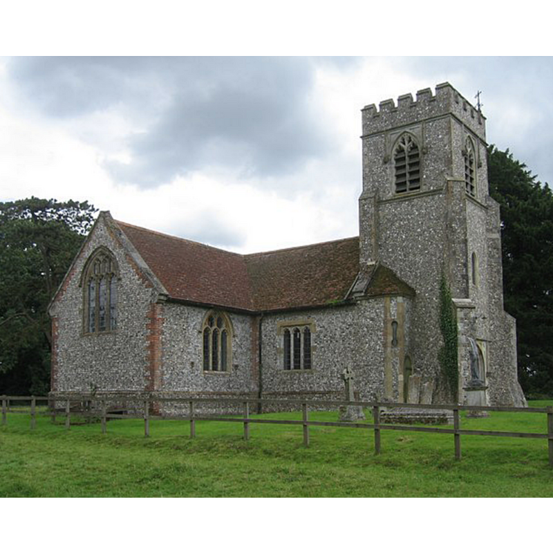
Image copyright © Given Up, 2008
CC-BY-SA-2.0
Results: 1 records
view of church exterior - north view
Scene Description: Source caption: "St Andrews church stands in splendid isolation in a pasture, at least quarter of a mile from the nearest dwelling. Explanations for this range from the Black Death through to the Civil War, the latter having been fought heavily over these parts. Whatever the reason, the foundations of the ancient village that surrounded it can still be seen. The church was rebuilt in the 18th Century and the tower, which holds three bells, was added around 1873. The church is most unusual in being perfectly cruciform."
Copyright Statement: Image copyright © Given Up, 2008
Image Source: digital photograph taken 20 July 2008 by Given Up [www.geograph.org.uk/photo/899395] [accessed 11 July 2018]
Copyright Instructions: CC-BY-SA-2.0
INFORMATION
Font ID: 17618FAR
Object Type: Baptismal Font1?
Font Century and Period/Style: 13th century, Decorated
Church / Chapel Name: Parish Church of St. Andrew
Church Patron Saint(s): St. Andrew
Church Notes: present church chiefly re-built 18th and 19thC
Church Address: Farleigh Wallop, Basingstoke RG25 2HH, UK -- Tel.: +44 1256 389474
Site Location: Hampshire, South East, England, United Kingdom
Directions to Site: Located off (E) the B3046, and the M3, 3 km SW of Basingstoke
Ecclesiastic Region: Diocese of Winchester
Historical Region: Hundred of Bermonsdpit
Additional Comments: disappeared fonts? (two? one medieval + one wood [cf. FontNotes])
Font Notes:
Click to view
There is an entry for Farleigh [Wallop] [variant spelling] in the Domesday survey [http://opendomesday.org/place/SU6246/farleigh-wallop/] [accessed 11 July 2018] but it mentions neither priest nor church in it. The Victoria County History (Hampshire, vol. 3, 1908) notes: "There was a church in the parish in the reign of Edward I [1272-1307] The church of St. John [...] was entirely rebuilt in the middle of the eighteenth century [...] and the west tower dates from 1873. [...] The octagonal stone font is modern, and replaces one of wood." The entry for this church in Historic England [Listing NGR: SU6194647370] reports a Victorian font in it. [NB: we have no information on either the original medieval font, or the wooden font replaced by the present one, which is Victorian] [the VCH has the dedication as St. John; Crockford's and the Church of England's web site [www.achurchnearyou.com/farleigh-wallop-st-andrew/] [accessed 25 August 2011] have St. Andrew].
COORDINATES
UTM: 30U 632258 5676334
Latitude & Longitude (Decimal): 51.22305, -1.106
Latitude & Longitude (DMS): 51° 13′ 22.98″ N, 1° 6′ 21.6″ W
REFERENCES
- Victoria County History [online], University of London, 1993-. URL: https://www.british-history.ac.uk.