Beaulieu / Beaulie / Bellus Locus Regis / Bewley
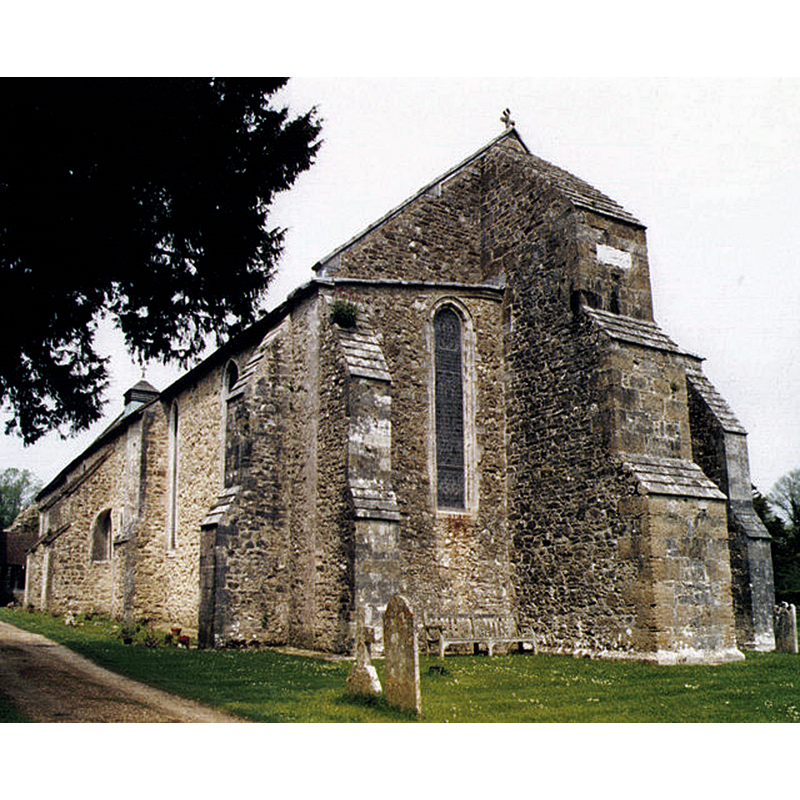
Image copyright © Michael Ford, 2009
CC-BY-SA-2.0
Results: 6 records
view of church exterior - southeast view
Scene Description: orientation uncertain, as this is the former refectory; the end in view is the apse of the present church
Copyright Statement: Image copyright © Michael Ford, 2009
Image Source: digital image of a photograph taken in 2004 by Michael Ford [www.geograph.org.uk/photo/1508485] [accessed 21 September 2018]
Copyright Instructions: CC-BY-SA-2.0
view of church exterior
![Source caption: ""Beaulieu parish church at the abbey" [NB: formerly the refectory of the abbey]](/static-50478a99ec6f36a15d6234548c59f63da52304e5/compressed/1180922013_compressed.png)
Scene Description: Source caption: ""Beaulieu parish church at the abbey" [NB: formerly the refectory of the abbey]
Copyright Statement: Image copyright © Charlesdrakew, 2007
Image Source: digital photograph taken early November 2007 by Charlesdrakew [https://commons.wikimedia.org/wiki/File:Beaulieu_abbey5.JPG] [accessed 21 September 2018]
Copyright Instructions: CC-BY-SA-2.0
view of church exterior in context
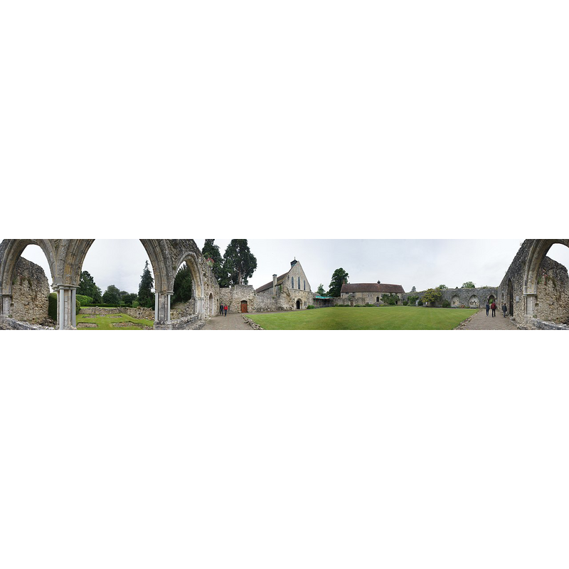
Scene Description: Panoramic view of the remains of Beaulieu Abbey; the building in the centre-left of the image was the former refectory and is now the Parish Church of Beaulieu
Copyright Statement: Image copyright © Adam labaigue, 2018
Image Source: digital photograph taken 8 June 2017 by Adam lebaigue [https://commons.wikimedia.org/wiki/File:Beaulieu_Abbey_Church_Panorama.jpg] [accessed 21 September 2018]
Copyright Instructions: CC-BY-SA-2.0
view of church interior - pulpit
![Source caption: "This great stone lectern, now used as a pulpit, [...] is one of only two surviving Cistercian monastic lecterns left in this country (the other is in Chester)"](/static-50478a99ec6f36a15d6234548c59f63da52304e5/compressed/1180922016_compressed.png)
Scene Description: Source caption: "This great stone lectern, now used as a pulpit, [...] is one of only two surviving Cistercian monastic lecterns left in this country (the other is in Chester)"
Copyright Statement: Image copyright © David Dixon, 2016
Image Source: digital photograph taken 24 May 2016 by David Dixon [www.geograph.org.uk/photo/4971662] [accessed 21 September 2018]
Copyright Instructions: CC-BY-SA-2.0
view of church interior - nave - looking east
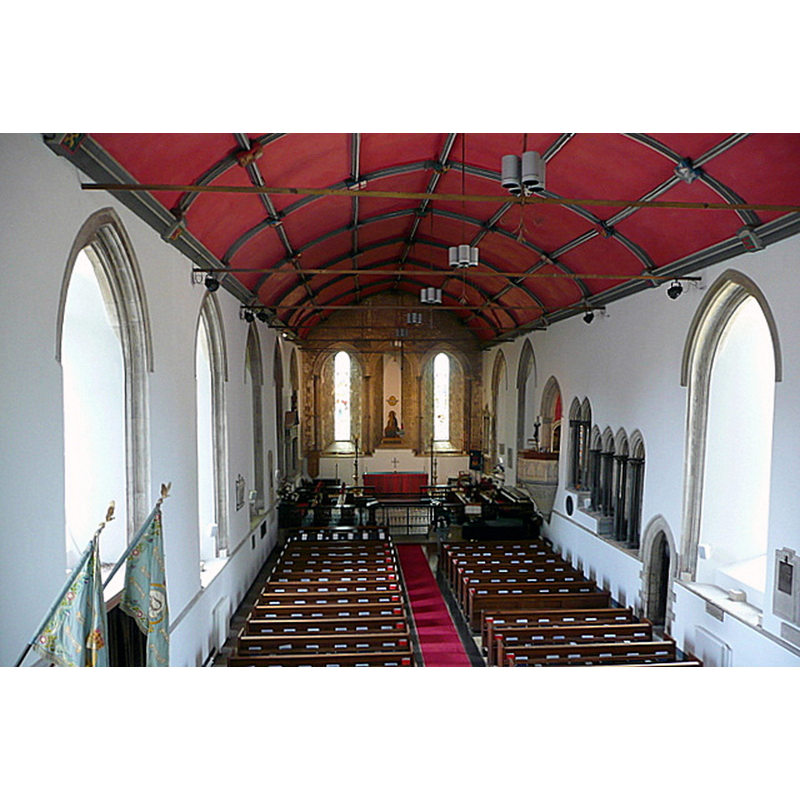
Scene Description: orientation uncertain, as this is the former refectory; the present pulpit was the lectern in the original building -- Source caption: "This is the inside of what is now Beaulieu parish church. It was, during the abbey times, the monks' refectory.""
Copyright Statement: Image copyright © Graham Horn, 2010
Image Source: digital photograph taken 5 June 2010 by Graham Horn [www.geograph.org.uk/photo/1508485] [accessed 21 September 2018]
Copyright Instructions: CC-BY-SA-2.0
view of font in context

Scene Description: the modern font at the back end of the nave
Copyright Statement: Image copyright © Sue Everett, 2014
Image Source: digital photograph taken 3 January 2014 by Sue Everett [www.flickr.com/photos/sue_everett/12027419513] [accessed 21 September 2018]
Copyright Instructions: PERMISSION NOT AVAILABLE -- IMAGE NOT FOR PUBLIC USE
INFORMATION
Font ID: 17559BEA
Object Type: Baptismal Font1?
Font Date: ca. 1205?
Font Century and Period/Style: 13th century (early?), Early English
Church / Chapel Name: Parish Church of the Blessed Virgin and Child [originally Cistercian Abbey Church of St. Mary, of which the refectory was turned into a church]
Church Patron Saint(s): St. Mary the Virgin
Church Address: Palace Ln, Beaulieu, Brockenhurst SO42 7YG, UK
Site Location: Hampshire, South East, England, United Kingdom
Directions to Site: Located 10 km from Borkenhurst
Ecclesiastic Region: Diocese of Winchester
Historical Region: Liberty of Beaulieu
Additional Comments: disappeared? (we have no information on the font of the original abbey church here)
Font Notes:
Click to view
No entry found for Beaulieu in the Domesday survey. The entry for this parish in the Victoria County History (Hampshire, vol. 4, 1911) notes: "In 1205 King John founded Beaulieu Abbey [...] In 1227, twenty-two years after the foundation of the abbey, the church of Beaulieu was completed. [...] The church was of greater area than any of the Cistercian order in this country [...] In April 1538 the abbey and all its possessions were surrendered to the Crown [...] adjoining the warming-house, but placed north and south, was the frater [i.e., refectory], now used as the parish church [...] The chapel is a detached building of late 13th-century date, of which all the walls remain to their full height, save half that on the north and the east gable"; there is no mention of its font in the VCH entry. The entry for the present parish church (former abbey refectory) in Historic England [Listing NGR: SP3883202548] does not mention a font, but states: "Rest of monuments and furnishings C19", which presumably includes the present font, a square basin raised on a broad central shaft and four outer colonnettes. [NB: we have no information on the font of this church]
COORDINATES
UTM: 30U 609238 5631137
Latitude & Longitude (Decimal): 50.82164, -1.44913
Latitude & Longitude (DMS): 50° 49′ 17.9″ N, 1° 26′ 56.87″ W
REFERENCES
- Victoria County History [online], University of London, 1993-. URL: https://www.british-history.ac.uk.