Eling / Edlinges / Elinga / Elinges
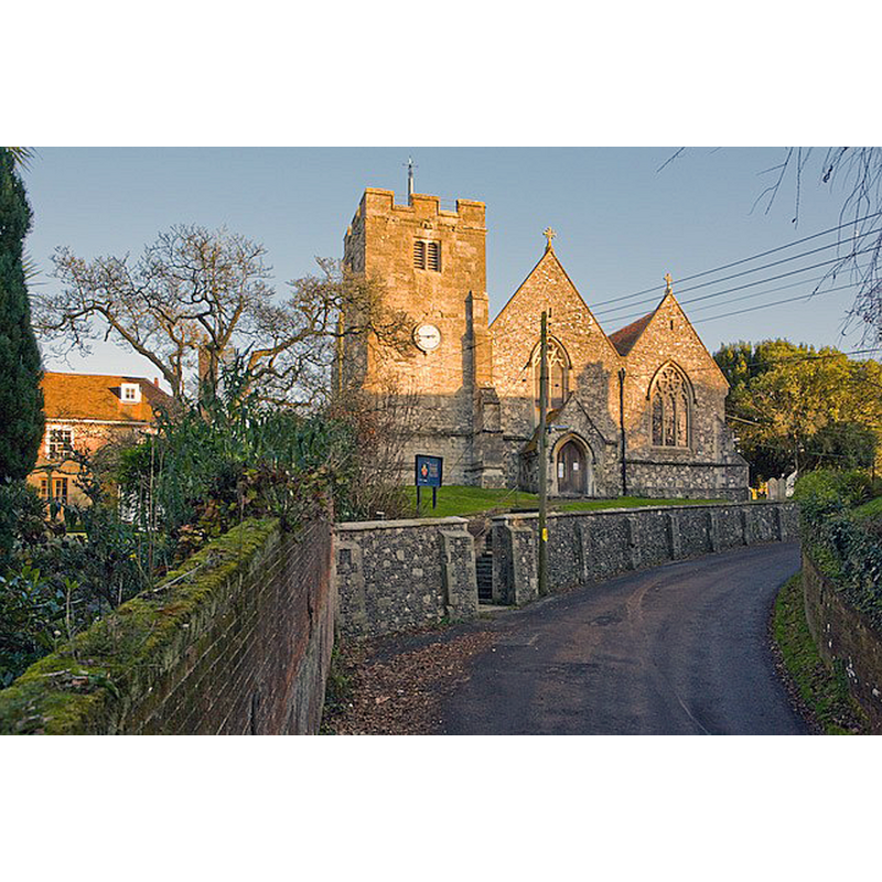
Image copyright © Peter Facey, 2008
CC-BY-SA-2.0
Results: 2 records
view of church exterior in context
Scene Description: the medieval church drastically renovated by Ferrey
Copyright Statement: Image copyright © Peter Facey, 2008
Image Source: digital photograph taken 5 December 2008 by Peter Facey [www.geograph.org.uk/photo/1072466] [accessed 17 September 2018]
Copyright Instructions: CC-BY-SA-2.0
design element - architectural - arcade - blind - round arches

Scene Description: on the ancient font seen ca. 1863; it disappeafred (?) during Ferrey's renovation

INFORMATION
Font ID: 17547ELI
Object Type: Baptismal Font1
Font Century and Period/Style: 11th century, Norman
Church / Chapel Name: Parish Church of St. Mary the Virgin
Font Location in Church: Inside the church, in the nave, opposite the [W?] entranceway, until ca. 1863
Church Patron Saint(s): St. Mary the Virgin
Church Notes: Domesday-time church; re-built/restored mid-19thC by Ferrey
Church Address: 7 Eling Hill, Eling, Southampton SO40 9HF, UK -- Tel.: +44 1329 239857
Site Location: Hampshire, South East, England, United Kingdom
Directions to Site: Located off (E) the A236, near, and now incorporated into Totton -Totton and Eling, 5 km NW of Southampton
Ecclesiastic Region: Diocese of Winchester
Historical Region: Hundred of Redbridge
Additional Comments: disappeared font? Last seen in the church ca. 1863?
Font Notes:
Click to view
There is an entry for Eling [variant spelling] in the Domesday survey [http://opendomesday.org/place/SU3612/eling/] [accessed 17 September 2018]; it reports "1 church. 0.5 church lands" in it. A letter to the editor of The Gentleman's Magazine (issue pf July 1865: 93) from W. Warwick King, reads: "Some years ago I visited the church of St. Mary, Elging", at which time he noted: "Opposite this porch, against a pillar, stood a Norman font with semicircular arcading." The letter writer further notes: "Two years ago, I heard the church had been restored by Mr. Ferrey, and felt no alarm, thinking it was in the hands of one who would preserve and not destroy objects of interest; but I was grievously disappointed. I found on my visit that the east window of the south chapel bad disappeared, and a poor copy substituted; that the font had gone entirely, and a wretched sprawling modern font in what might be called the Norman style placed near the west door. The old font and the cast window with little expense might have been properly restored. [...] I have thus given you another lamentable instance of so-called restoration, which you will see is in reality absolute destruction, and it is high time for all who care for the works of our forefathers to protest against and discourage by all means in their power any restoration which is not essentially conservative and confined to the preservation of the fabric and its accessories, except the removal of such modern excrescences as high pews and other relics of Puritanism. Architects are too fond of leaving the individual impress of their own ideas on our ancient buildings." The Victoria County History (Hampshire, vol. 4, 2011) notes: "There was a church at Eling at the time of the Domesday Survey [i.e., 1086) [...] The earliest church of which traces remain was perhaps of the 11th century [...] Unfortunately the whole church has also been scraped and retooled. [...] The [present] font is modern." The entry for this church in Historic England [Listing NGR: SP3858402580] notes: "11[thC] Parish church. Of Saxon and Norman origin as an aisleless nave and chancel, with transepts, with C13 restoration of the chancel, C14 south chapel, C15 north aisle and tower, early south aisle and north chapel rebuilt in a substantial general restoration of 1863 by B Ferrey, which included south and west porches and a north vestry"; the entry mentions no font in it. [NB: we have no information on the whereabouts of the old font, which disappeared around 1863 according to the letter above]. The modern font is located in the northwest corner of the nave, just north of the west porch; the church has two porches, south and west, and it is likely, though not certain, that the new font would have been placed in the same position as the old had been]
COORDINATES
UTM: 30U 606888 5640972
Latitude & Longitude (Decimal): 50.91049, -1.4796
Latitude & Longitude (DMS): 50° 54′ 37.76″ N, 1° 28′ 46.56″ W
MEDIUM AND MEASUREMENTS
Material: stone
REFERENCES
- Victoria County History [online], University of London, 1993-. URL: https://www.british-history.ac.uk.