Ravenstone nr. Newport Pagnell / Raunston / Raveneston / Ravenstione / Ravenston / Rowenstone
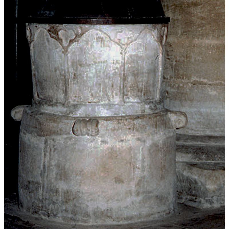
Image copyright © John Salmon, 2012
CC-BY-SA-2.0
Results: 6 records
view of font
Copyright Statement: Image copyright © John Salmon, 2012
Image Source: edited detail of a photograph taken in 1995 by John Salmon [www.geograph.org.uk/photo/3265968] [accessed 24 February 2016]
Copyright Instructions: CC-BY-SA-2.0
view of font and cover in context
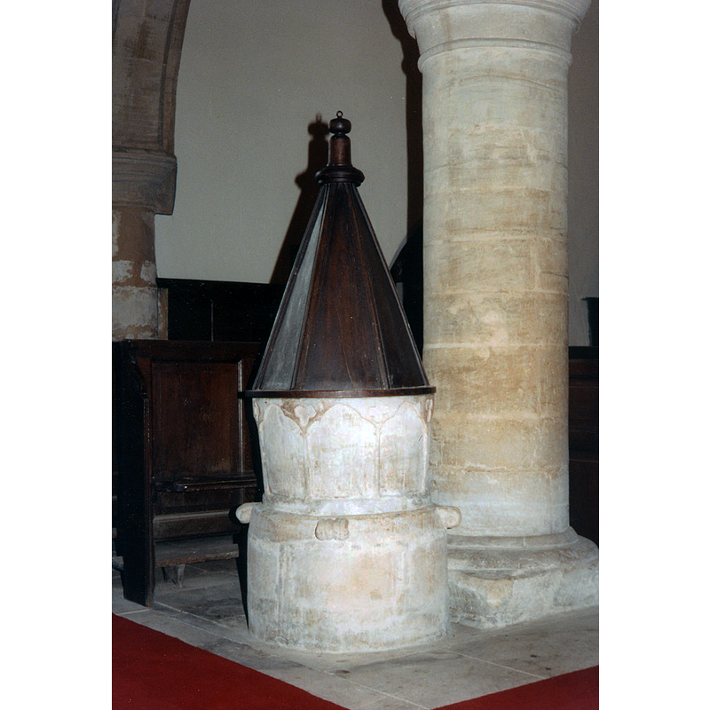
Copyright Statement: Image copyright © John Salmon, 2012
Image Source: photograph taken in 1995 by John Salmon [www.geograph.org.uk/photo/3265968] [accessed 24 February 2016]
Copyright Instructions: CC-BY-SA-2.0
design element - architectural - arcade - blind - trefoiled arches - columns with capitals
Scene Description: wide arches; very shallow carving
Copyright Statement: Image copyright © John Salmon, 2012
Image Source: edited detail of a photograph taken in 1995 by John Salmon [www.geograph.org.uk/photo/3265968] [accessed 24 February 2016]
Copyright Instructions: CC-BY-SA-2.0
design element - motifs - trefoil
Scene Description: in the spandrels of the arcade
Copyright Statement: Image copyright © John Salmon, 2012
Image Source: edited detail of a photograph taken in 1995 by John Salmon [www.geograph.org.uk/photo/3265968] [accessed 24 February 2016]
Copyright Instructions: CC-BY-SA-2.0
view of church exterior - south view
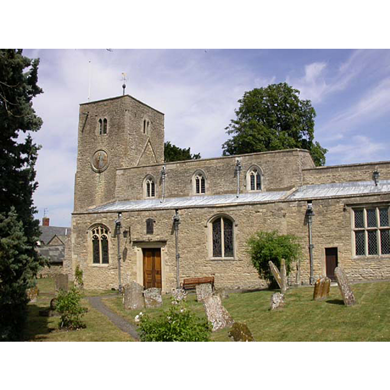
Copyright Statement: Image copyright © Kokai, 2011
Image Source: digital photograph taken by Kokai [www.yourlocalweb.co.uk/buckinghamshire/ravenstone/pictures/]
Copyright Instructions: CC-BY-SA-2.0
design element - motifs - volute - 4?
Scene Description: at 90-degree angles on the upper base end
Copyright Statement: Image copyright © John Salmon, 2012
Image Source: edited detail of a photograph taken in 1995 by John Salmon [www.geograph.org.uk/photo/3265968] [accessed 24 February 2016]
Copyright Instructions: CC-BY-SA-2.0
INFORMATION
Font ID: 17367RAV
Object Type: Baptismal Font1
Font Century and Period/Style: 13th century (early?), Early English
Church / Chapel Name: Parish Church of All Saints
Font Location in Church: Inside the church
Church Patron Saint(s): All Saints
Church Address: 7 N End, Ravenstone, Milton Keynes MK46 5AN
Site Location: Buckinghamshire, South East, England, United Kingdom
Directions to Site: Located 5 km WSW of Olney, 8 km NNW of Newport Pagnell, near the border with Nhants.
Ecclesiastic Region: Diocese of Oxford
Historical Region: Hundred of Bunsty [in Domesday] -- Hundred of Newport
Additional Comments: disappeared font? (the one from the 11thC-12thC church?)
Font Notes:
Click to view
There is an entry for this Ravenstone [variant spelling] in the Domesday survey [http://opendomesday.org/place/SP8550/ravenstone/] [accessed 24 February 2016], but it mentions neither cleric nor church in it. Sheahan (1862) writes: "an ancient edifice [...] built probably in the 12th century [...] very Early English [...] The font is a large cylindrical basin, externaly ornamented with a series of rude arches having trefoil heads". The Victoria County History (Buckingham, vol. 4, 1927) notes: "Some herring-bone rubble in the west wall of the nave indicates the former existence of an 11th-century church [...] The early 13th-century font has a tapering circular bowl carved with trefoiled arcading having quatrefoils in the spandrels; the plain circular base has four volute-like reeded projections near the top, probably intended for foliage. The oak cover is a tall plain pyramid with turned top, and dates from the 17th century."
COORDINATES
UTM: 30U 653314 5780073
Latitude & Longitude (Decimal): 52.149853, -0.759122
Latitude & Longitude (DMS): 52° 8′ 59.47″ N, 0° 45′ 32.84″ W
MEDIUM AND MEASUREMENTS
Material: stone
Font Shape: tub-shaped, mounted
Basin Interior Shape: round
Basin Exterior Shape: round
LID INFORMATION
Date: 17th-century?
Material: wood, oak
Apparatus: no
Notes: [cf. FontNotes]
REFERENCES
- Victoria County History [online], University of London, 1993-. URL: https://www.british-history.ac.uk.
- Sheahan, James Joseph, History and topography of Buckinghamshire, comprising a general survey of the county, preceded by an epitome of the early history of Great Britain, London; Pontefract: Longman, Green, Longman, and Roberts; William Edward Bonas [...], 1862, p. 593