Pitchcott / Pichecote / Pitchcot / Pitchcote / Pychcote
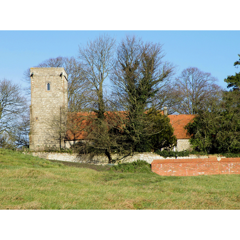
Image copyright © R~P~M, 2008
CC-BY-SA-3.0
Results: 1 records
view of church exterior - south view
Scene Description: NB: this building no longer functions as a church; it has been deconsecrated and is now a private dwelling
Copyright Statement: Image copyright © R~P~M, 2008
Image Source: digital photograph taken 5 December 2008 by R~P~M [http://www.flickr.com/photos/rpmarks/3085053223/]
Copyright Instructions: CC-BY-SA-3.0
INFORMATION
Font ID: 17337PIT
Object Type: Baptismal Font1?
Font Century and Period/Style: 13th century, Early English
Church / Chapel Name: Parish Church of St. Giles [deconsecrated]
Font Location in Church: [cf. FontNotes]
Church Patron Saint(s): St. Giles [aka Aegidus, Egidus, Gilles]
Church Notes: The Church of St. Giles, originally from the Early English period, renovated in the 1860s; now deconsecrated and turned into a private residence: Other fittings have been sold and dispersed. Building due to be converted to house at time of listing. RCHM II p. 235-6." [in British Listed Buildings [http://www.britishlistedbuildings.co.uk/en-42187-church-of-st-giles-pitchcott]]
Site Location: Buckinghamshire, South East, England, United Kingdom
Directions to Site: Located 4 km NE of Waddesdon, 6 km S of Winslow, 12 km NW of Aylesbury
Ecclesiastic Region: Diocese of Oxford
Historical Region: Hundred of Ashendon
Additional Comments: disused font? Disappeared font? [a plate on the gate leading to the church now [2006] informs that the former church is now a private dwelling and is not open to the public]
Font Notes:
Click to view
No entry for Pitchcott found in the Domesday survey. Lipscomb (1831- ) writes: "The font, which is octagonal (the bason nineteen inches in diameter and eleven inches deep) is supported by a fluted pillar." In Sheahan (1862), after Lipscomb; Sheahan (ibid.) describes the church as "a plain edifice, chiefly in the Early English Style. The Victoria County History (Buckingham, vol. 4, 1927) notes [after Lipscomb, 1847] : "The church was in a most dilapidated condition in 1817", and that it was restored in 1864. The VCH (ibid.) notes: "The chancel dates from the first half of the 13th century, and the nave is of earlier date, though none of its original windows or doorways has survived", but mentions no font in it. [NB: the church building was deconsecrated -no exact date available yet, but before 2001- sold and turned into a private dwelling; we have no information on the whereabouts of the medieval font; it could very well have been replaced in the mid-19th century restoration].
COORDINATES
UTM: 30U 646225 5749318
Latitude & Longitude (Decimal): 51.875446, -0.875783
Latitude & Longitude (DMS): 51° 52′ 31.61″ N, 0° 52′ 32.82″ W
MEDIUM AND MEASUREMENTS
Material: stone
Font Shape: octagonal, mounted
Basin Interior Shape: round
Basin Exterior Shape: octagonal
Diameter (includes rim): 47.5 cm*
Basin Depth: 27.5 cm*
Notes on Measurements: * [in inches in Lipscomb (1831- )
REFERENCES
- Victoria County History [online], University of London, 1993-. URL: https://www.british-history.ac.uk.
- Sheahan, James Joseph, History and topography of Buckinghamshire, comprising a general survey of the county, preceded by an epitome of the early history of Great Britain, London; Pontefract: Longman, Green, Longman, and Roberts; William Edward Bonas [...], 1862, p. 414