Guerno / Le Guerno / Ar Gwernoù
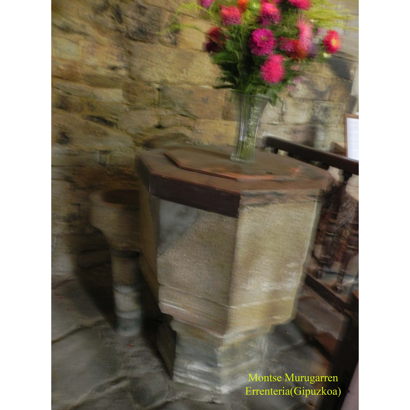
Image copyright © Montse Murugarren, 2010
Permission received from the author via Mikel Unanue (email of 18 April 2010)
Results: 5 records
BBL01: design element - motifs - groove - parallel - 2
Copyright Statement: Image copyright © Montse Murugarren, 2010
Image Source: digital photograph taken 10 August 2010 by Montse Murugarren
Copyright Instructions: Permission received from the author via Mikel Unanue (email of 18 April 2010)
LB01: design element - motifs - moulding
Copyright Statement: Image copyright © Montse Murugarren, 2010
Image Source: digital photograph taken 10 August 2010 by Montse Murugarren
Copyright Instructions: Permission received from the author via Mikel Unanue (email of 18 April 2010)
view of font and cover
Copyright Statement: Image copyright © Montse Murugarren, 2010
Image Source: digital photograph taken 10 August 2010 by Montse Murugarren
Copyright Instructions: Permission received from the author via Mikel Unanue (email of 18 April 2010)
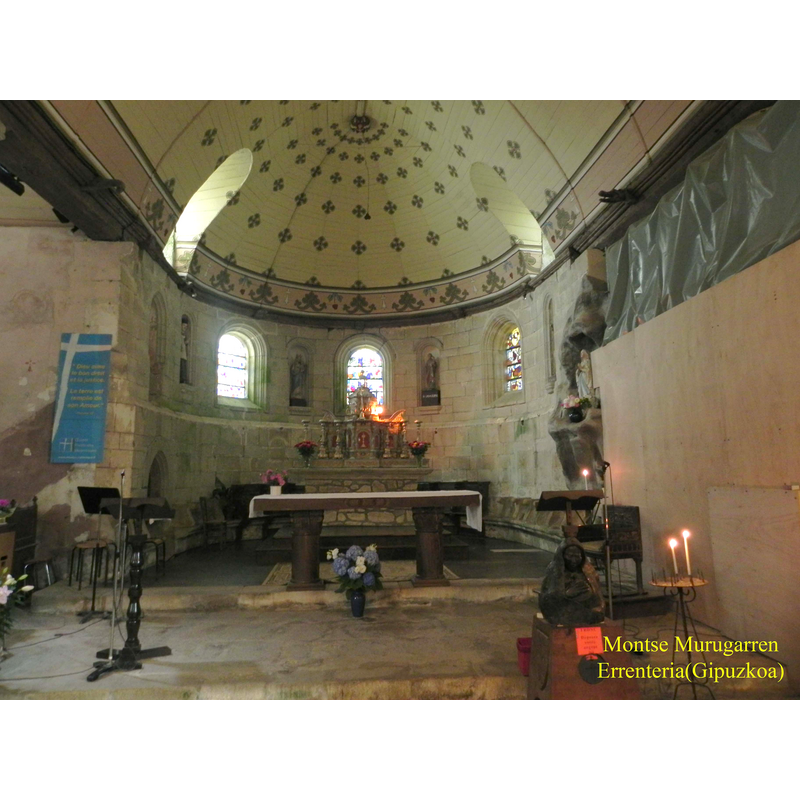
view of church interior - chancel and east end
Copyright Statement: Image copyright © Montse Murugarren, 2010
Image Source: digital photograph taken 10 August 2010 by Montse Murugarren
Copyright Instructions: Permission received from the author via Mikel Unanue (email of 18 April 2010)
view of font in context
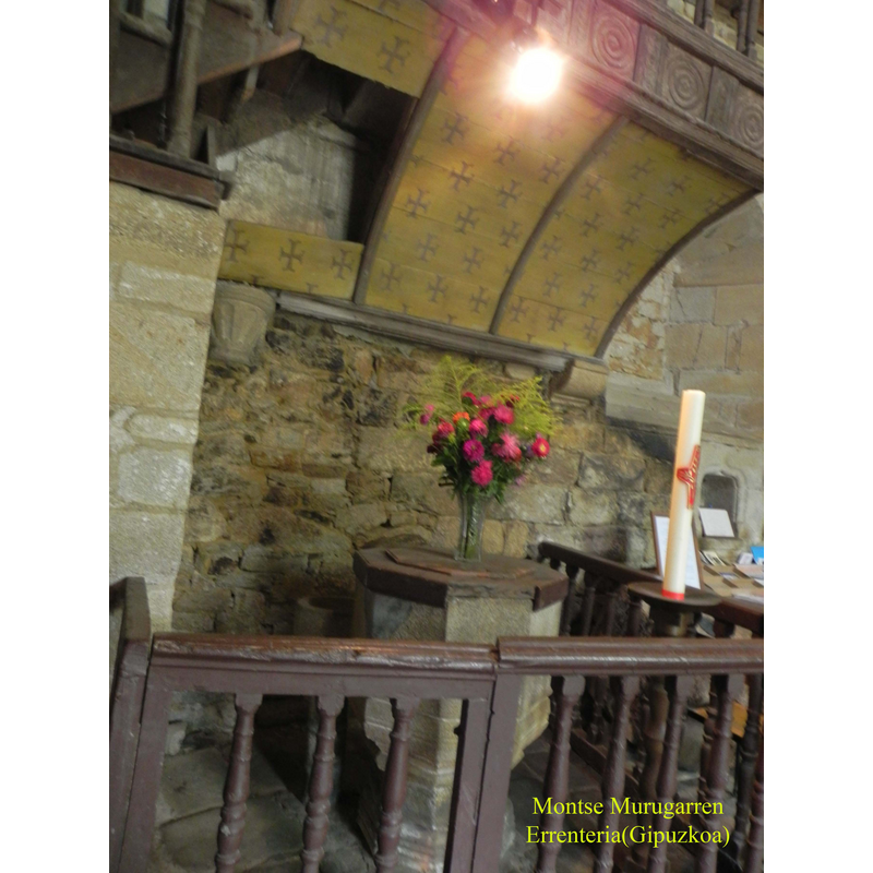
Scene Description: at the west end of the nave, on the north side
Copyright Statement: Image copyright © Montse Murugarren, 2010
Image Source: digital photograph taken 10 August 2010 by Montse Murugarren
Copyright Instructions: Permission received from the author via Mikel Unanue (email of 18 April 2010)
INFORMATION
Font ID: 16989GUE
Object Type: Baptismal Font1
Font Date: ca. 1570-1590?
Font Century and Period/Style: 16th century(late?), Renaissance
Workshop/Group/Artisan: double font
Church / Chapel Name: Église Notre-Dame [aka Église des Templiers, Église Sainte-Anne, Église Saint Jean Baptiste]
Font Location in Church: Inside the church, at the W end of the nave, N side
Church Patron Saint(s): St. Mary the Virgin
Church Notes: present church was built between 1570 and 1590 over the remains of an 11thC church; usually known as 'Eglise des Templiers', although it belonged to the Hospitallers of St. John instead.-- confussing dedication: it appears in different sources as dedicated to: St. Anne, St. Mary and St. John the Baptist. The Ministere de la Culture database has Sainte-Anne. Listed in Mérimée [ref.: PA00091255]: "Eglise reconstruite en 1570 à l'emplacement d'un édifice plus ancien dont il subsiste des parties dans l'édifice actuel. L'origine remonte probablement aux Templiers. En 1160, le fief fut donné à l'ordre des Hospitaliers de Saint-Jean de Jérusalem. L'afflux des pèlerins était tel qu'une chaire extérieure fut placée contre la façade sud. En effet, le culte de Sainte-Anne attirait de nombreux marins et celui de la Passion rassemblait une foule de pèlerins le Vendredi Saint. Un pèlerin en provenance de la Terre sainte y aurait laissé un fragment de la Vraie Croix. Une petite croix en argent doré du 13e siècle conserve cette relique. Le pèlerinage lui-même doit remonter au 12e siècle."
Church Address: Pl. de l'Église, 56190 Le Guerno, France -- Tel.: +33 2 97 42 94 76
Site Location: Morbihan, Bretagne, France, Europe
Directions to Site: Located off the D20, 10 km ENE of Muzillac
Ecclesiastic Region: Diocese de Vannes
Historical Region: Arc Sud Bretagne
Additional Comments: disappeared font? (the one from the 11thC church here)
Font Notes:
Click to view
Baptismal font probably of the late 16th century of the type common in this area, consisting of two basins: the primary basin is hexagonal with plain tapering sides, raised on a moulded hexagonal base; the attached secondary basin is much smaller in size, consisting of a small and plain cylindrical base raised on a slender circular shaft. The stone apears to be granite, a common medium in this area. The wooden cover is hexagonal, flat and plain, and covers only the larger basin.
Credit and Acknowledgements: We are grateful to Montse Murugarren for the photographs of this church and font
COORDINATES
UTM: 30T 544554 5270098
Latitude & Longitude (Decimal): 47.582761, -2.407486
Latitude & Longitude (DMS): 47° 34′ 57.94″ N, 2° 24′ 26.95″ W
MEDIUM AND MEASUREMENTS
Material: stone, granite?
Font Shape: double-font, hexagonal, mounted
Basin Interior Shape: round [both basins]
Basin Exterior Shape: double basin, 1) hexagonal 2) round [secondary basin]
Drainage Notes: N/A, but usually in the smaller basin
LID INFORMATION
Material: wood
Apparatus: no
Notes: [cf. FontNotes]