Cheam / Cegham / Ceiham / Cheame / Cheham / Cheyhem / West Cheam
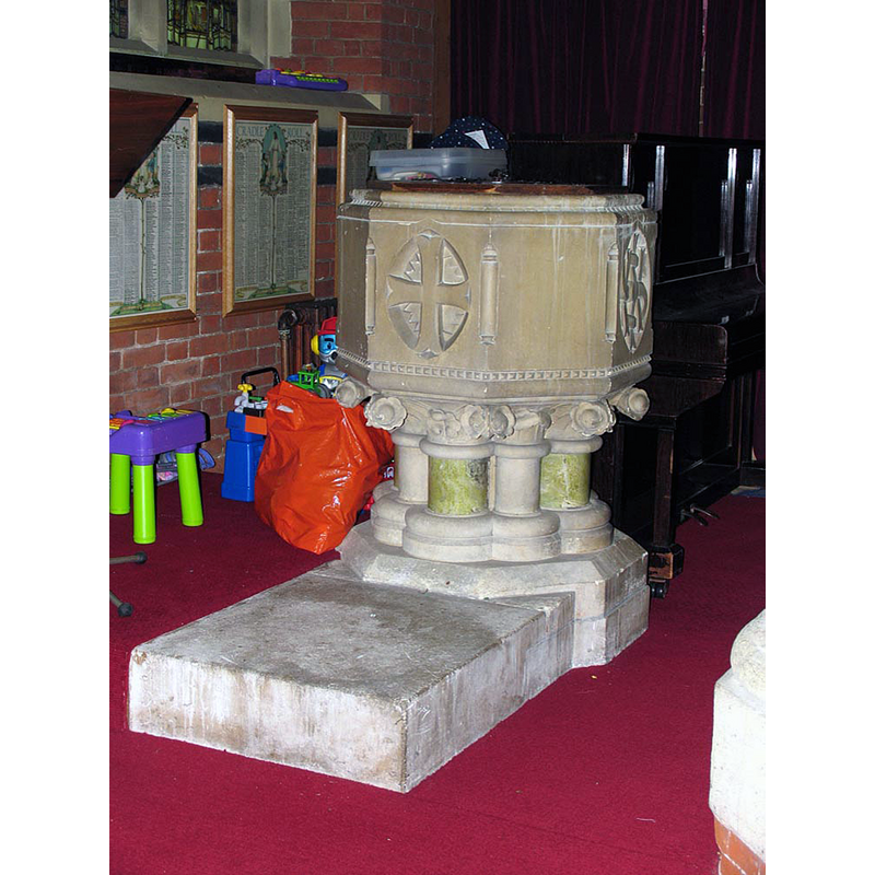
Image copyright © John Salmon, 2010
CC-BY-SA-2.0
Results: 4 records
view of font and cover
Copyright Statement: Image copyright © John Salmon, 2010
Image Source: digital photograph taken 9 November 2005 by John Salmon [www.geograph.org.uk/photo/1664949] [accessed 17 March 2016]
Copyright Instructions: CC-BY-SA-2.0
view of church exterior - south view
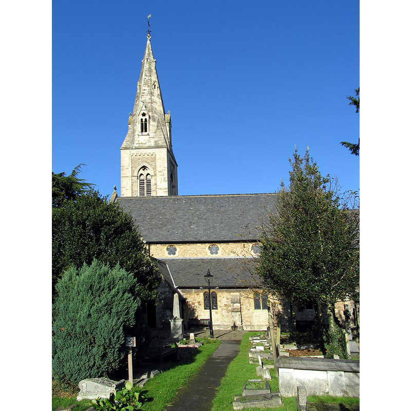
Copyright Statement: Image copyright © John Salmon, 2010
Image Source: digital photograph taken 9 November 2005 by John Salmon [www.geograph.org.uk/photo/1664880] [accessed 17 March 2016]
Copyright Instructions: CC-BY-SA-2.0
view of church interior - nave - looking east
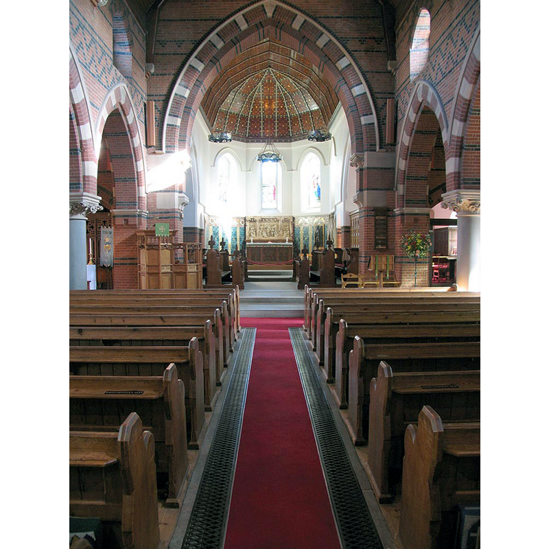
Copyright Statement: Image copyright © John Salmon, 2010
Image Source: digital photograph taken 9 November 2005 by John Salmon [www.geograph.org.uk/photo/1664964] [accessed 17 March 2016]
Copyright Instructions: CC-BY-SA-2.0
view of font in context
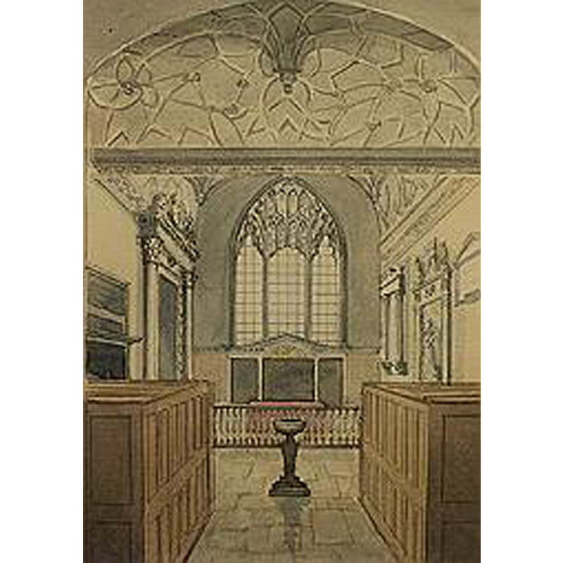
Scene Description: the 18th-century (?) font in the context of the Lumley Chapel
Copyright Statement: Image copyright © London Borough of Sutton, 2008
Image Source: painting by Gideon Yates (1790-1837) in the Sutton Heritage Collection, in the London Borough of Sutton website [www.sutton.gov.uk/index.aspx?articleid=1906] [accessed 9 August 2010]
Copyright Instructions: No known copyright restriction / Fair Dealing
INFORMATION
Font ID: 16839CHE
Object Type: Baptismal Font1?
Font Century and Period/Style: 11th century, Pre-Conquest? / Norman
Church / Chapel Name: Parish Church of St. Dunstan [later in St. Albans']
Church Patron Saint(s): St. Dunstan
Church Address: Church Road, Cheam, Gt. London, SM3 8QH
Site Location: Greater London, South East, England, United Kingdom
Directions to Site: Located in the London borough of Sutton, in SSW Gt. London, near the present border with Surrey
Ecclesiastic Region: Diocese of Southwark [originally in the diocese of Winchester, a peculiar of Canterbury]
Historical Region: Hundred of Wallington -- formerly in Surrey
Additional Comments: disappeared font? (the one from the Domesday-time church here) / replacement font / moved font
Font Notes:
Click to view
There is an entry for Cheam [variant spelling] in the Domesday survey [http://opendomesday.org/place/TQ2463/cheam/] [accessed 17 March 2016]; it reports a church in it. Brayley (1850), reports on a notice inside the church that reads: "the church of Cheme was burnt by lightning in the year 1639"; Brayley (ibid.) adds: "The font is a plain circular basin of stone, standing on a pedestal, in front of the communion-table." The Victoria County History (Surrey, vol. 4, 1912) notes: "There was a church in Cheam on the archbishop's land at the time of the Survey. [...] The church of ST. DUNSTAN, erected in 1864, stands on a new site to the north of the former church, the east end of the chancel of which has been preserved as a sepulchral chapel"; the VCH entry mentions no font in it. The London Borough of Sutton website for the Church of St. Albans, in Cheam [www.sutton.gov.uk/index.aspx?articleid=1903] [accessed 9 August 2010], notes: "The font dates from the mid-18th century and came from the old St Dunstan's Church". This same entry adds: "The Domesday book mentions a church part of which is still standing in the churchyard as the Lumley Chapel. The chapel was the chancel of the church until 1864 when most of the old church was demolished and replaced by the present building. [...] The Lumley Chapel is the oldest standing building in the London Borough of Sutton, as the fragments of blocked window in the north wall is of late Saxon or early Norman date." The same website illustrates "a painting by Gideon Yates in the Sutton Heritage Collection" that shows the nave of the Chapel looking east, with a baptismal font in the centre of the aisle, a font that fits the 18th-century date description given in Brayley [cf. supra]. The said font appears as typically Georgian, a small hemispherical basin raised on a baluster-type pedestal base. The present font consists of a large octagonal basin with vertical sides decorated on the alternate panels with circled crosses, the eight angles decorated with stylised colonnettes, row of nail-nead motif below; on a base of short columns with large foliated capitals, moulded bases; a typical unbalanced Victorian rendering of earlier font models; the pistacchio-hue shafts are particularly hedious. [NB: we have no information on the medieval font here].
COORDINATES
UTM: 30U 693712 5693601
Latitude & Longitude (Decimal): 51.3606, -0.217516
Latitude & Longitude (DMS): 51° 21′ 38.16″ N, 0° 13′ 3.06″ W
REFERENCES
- Victoria County History [online], University of London, 1993-. URL: https://www.british-history.ac.uk.
- Brayley, Edward Wedlake, A topographical history of Surrey, London: G. Willis, 1850, vol. 4: 80