Shalford nr. Guildford / Scaldefor / Scaudeford / Shaldeford / Shalforde
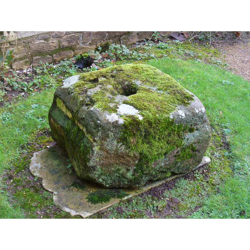
Image copyright © Colin Smith, 2016
Image and permission received (e-mail of 7 February 2016)
Results: 4 records
view of basin?
Scene Description: as found on 10 January 2016 outsid, by the porch of the church -- is this what the VCH described in 1911?: "The old font is at present turned upside down, and placed as a mounting block outside the vicarage. It may shortly be restored to the church."
Copyright Statement: Image copyright © Colin Smith, 2016
Image Source: digital photograph taken 10 January 2016 by Colin Smith
Copyright Instructions: Image and permission received (e-mail of 7 February 2016)
view of basin?
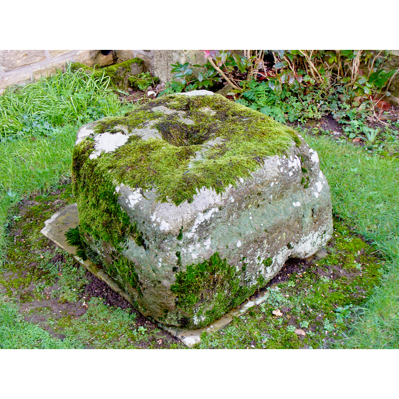
Scene Description: as found on 10 January 2016 outsid, by the porch of the church -- is this what the VCH described in 1911?: "The old font is at present turned upside down, and placed as a mounting block outside the vicarage. It may shortly be restored to the church."
Copyright Statement: Image copyright © Colin Smith, 2016
Image Source: digital photograph taken 10 January 2016 by Colin Smith
Copyright Instructions: Image and permission received (e-mail of 7 February 2016)
view of church exterior - northwest view
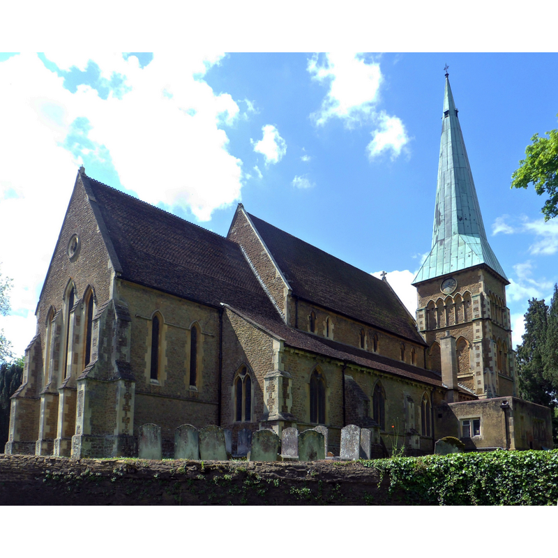
Copyright Statement: Image copyright © [in the public domain]
Image Source: digital photograph taken 15 May 2004 by Hassocks5489 [http://commons.wikimedia.org/wiki/File:St_Mary_the_Virgin's_Church,_The_Street,_Shalford_(May_2014)_(3).jpg] [accessed 3 March 2015]
Copyright Instructions: CC-Zero
view of church exterior - south view
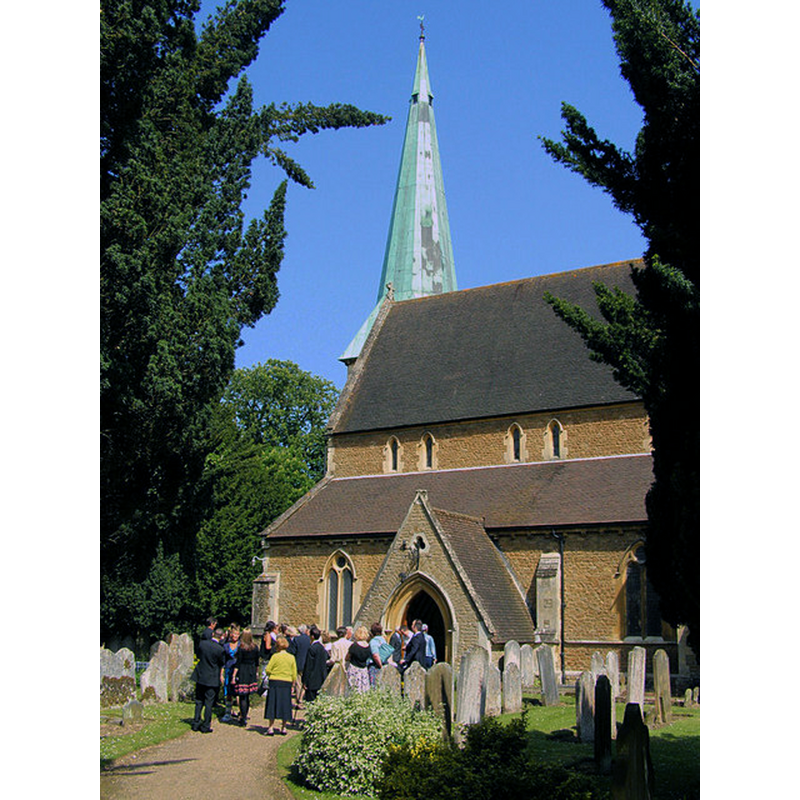
Scene Description: Source caption: "St Mary's Church, Shalford. St Mary's church was built in 1846 but still retains features and monuments from an earlier church on this site. The photo was taken as guests arrived at church for the christening service of little Evie Blick."
Copyright Statement: Image copyright © Kevin Gordon, 2009
Image Source: digital photograph taken 24 May 2009 by Kevin Gordon [www.geograph.org.uk/photo/1317664] [accesssed 3 March 2015]
Copyright Instructions: CC-BY-SA-2.0
INFORMATION
Font ID: 16820SHA
Object Type: Baptismal Font1?
Font Century and Period/Style: 11th century, Pre-Conquest? / Norman
Church / Chapel Name: Parish Church of St. Mary
Font Location in Church: [cf. FontNotes]
Church Patron Saint(s): St. Mary the Virgin
Church Address: The Street, Shalford, Surrey, GU4 8BP
Site Location: Surrey, South East, England, United Kingdom
Directions to Site: Located on the A281, SSE of Guildford
Ecclesiastic Region: Diocese of Guildford
Historical Region: Hundred of Blackheath [in Domesday]
Additional Comments: disappeared font? (the one from the Domesday-time church here), or is this block of stone outside the porch in February 2016 it? or a later medieval font?
Font Notes:
Click to view
There is an entry for this Shalford [variant spelling] in the Domesday survey [http://domesdaymap.co.uk/place/TQ0047/shalford/] [accessed 3 March 2015]; it mentions a church in it. The Victoria County History (Surrey, vol. 3, 1911) notes: "The church of St. Mary is the third that has stood on the present site since 1789, in which year the mediaeval building, possibly retaining parts of that mentioned in Domesday, was rebuilt [...] The old font is at present turned upside down, and placed as a mounting block outside the vicarage. It may shortly be restored to the church." [NB: we have no current information on this font, unless it is the block photographed in 2016 outside the porch]. The Ecclesiologist (vol. 9, 1849: 69) reports a new church in Shalford, near Guildord, with a font in it: "The font, we suppose, belonged to the old church; a mere marble vase." [NB: not clear which church the note refers to, but probably the 1789 one mentioned in the VCH entry above -- a square block resembling an upturned basin is still outside the church, by the porch; it has a large drain hole].
Credit and Acknowledgements: We are grateful to Colin Smith for his photographs of what may be the old missing font at Shalford St Mary's
COORDINATES
UTM: 30U 669568 5677177
Latitude & Longitude (Decimal): 51.220767, -0.571759
Latitude & Longitude (DMS): 51° 13′ 14.76″ N, 0° 34′ 18.33″ W
MEDIUM AND MEASUREMENTS
Material: stone
Drainage System: yes
REFERENCES
- Victoria County History [online], University of London, 1993-. URL: https://www.british-history.ac.uk.