Myland / Miland / Milanda / Milaund / Mile End / Mileende / Milend / Myle Ende / Mylend / Mylende
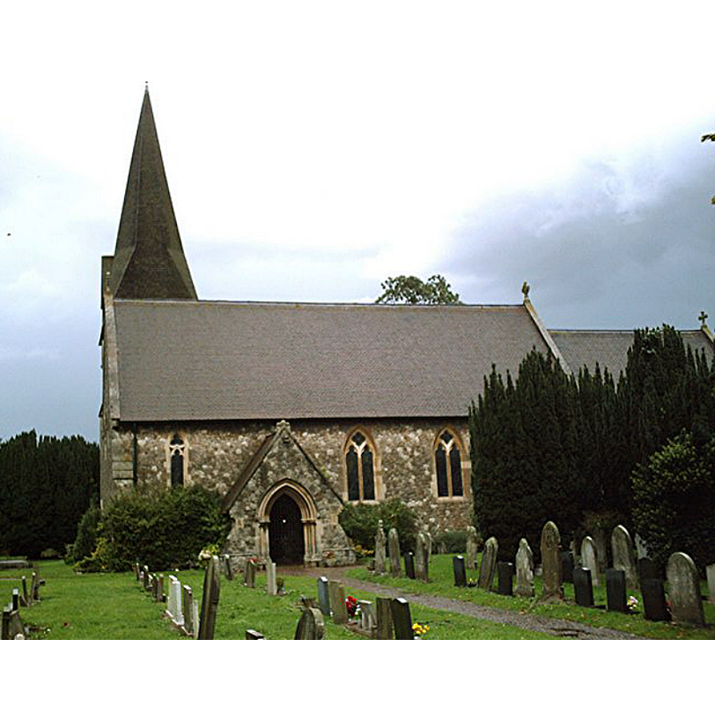
Image copyright © John Myers, 2006
CC-BY-SA-2.0
Results: 5 records
view of church exterior - south view
Copyright Statement: Image copyright © John Myers, 2006
Image Source: digital photograph taken 17 October 2006 by John Myers [www.geograph.org.uk/photo/536956] [accessed 12 June 2018]
Copyright Instructions: CC-BY-SA-2.0
view of church exterior in context - west view
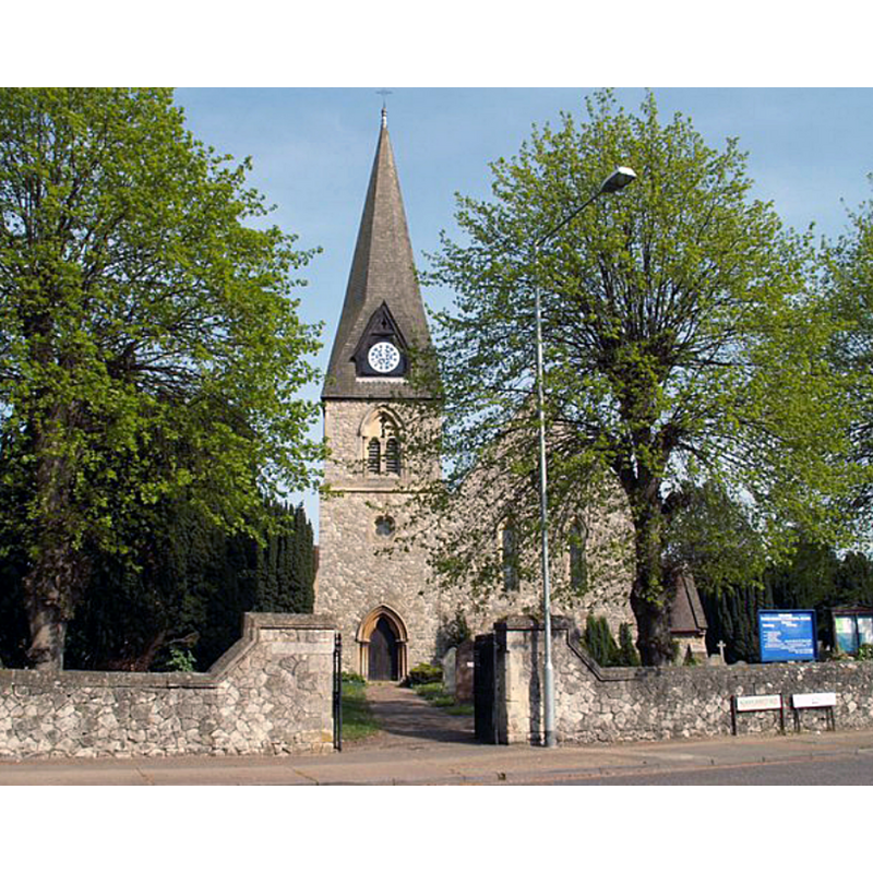
Scene Description: the mid-19thC church
Copyright Statement: Image copyright © Robert Edwards, 2008
Image Source: igital photograph taken 5 May 2008 by Robert Edwards [www.geograph.org.uk/photo/800166] [accessed 12 June 2018]
Copyright Instructions: CC-BY-SA-2.0
view of church exterior in context - ruins
![Source caption: "Old Mile End Church (from the north-east) ruins of St Michael, Myland, Colchester, Essex [...] The old church was demolished, but its remains survive in Rectory Close, not far from the railway station".](/static-50478a99ec6f36a15d6234548c59f63da52304e5/compressed/1180612001_compressed.png)
Scene Description: Source caption: "Old Mile End Church (from the north-east) ruins of St Michael, Myland, Colchester, Essex [...] The old church was demolished, but its remains survive in Rectory Close, not far from the railway station".
Copyright Statement: Image copyright © Simon Knott, 2017
Image Source: digital photograph taken 20 February 2017 by Simon Knott [www.flickr.com/photos/norfolkodyssey/32863650522] [accessed 12 June 2018]
Copyright Instructions: Standing permission
view of church exterior in context - southeast view
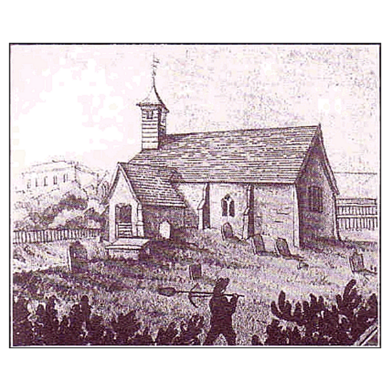
Scene Description: the old church before its total collapse and demolition
Copyright Statement: Image copyright © [in the public domain?]
Image Source: digital image of an undated illustration in The Smiths of Essex [http://www.thesmithsofessex.info/parishes/Mile End_files/image002.gif] [accessed 12 June 2018]
Copyright Instructions: PD?
view of church exterior in context - southeast view

Scene Description: the old church before its total collapse and demolition
Copyright Statement: Image copyright © Pinterest, 2018
Image Source: digital image of an undated photograph in PINREST [https://i.pinimg.com/originals/bb/03/97/bb0397f1cc4b400a807f26f7e1186e2a.jpg] [accessed 12 June 2018]
Copyright Instructions: PERMISSION NOT AVAILABLE -- IMAGE NOT FOR PUBLIC USE
INFORMATION
Font ID: 16799MYL
Object Type: Baptismal Font1?
Font Century and Period/Style: 13th century, Medieval
Church / Chapel Name: Old Parish Church of St. Michael [collapsed after being abandoned in mid-19thC]
Church Patron Saint(s): St. Michael
Church Address: [address for the new church: Mile End Road, Colchester CO4 5DY, UK -- Tel.: +44 1206 855040] -- [coordinates given for Colchester Railway Station, near the ruins of the old church]
Site Location: Essex, East, England, United Kingdom
Directions to Site: Located near, and now a N suburb of Colchester [NB: the ruins of the old church can still be seen near the Colchester Railway Station]
Ecclesiastic Region: Diocese of Chelmsford
Historical Region: Hundred of Tandridge
Additional Comments: disappeared font? (the one from the mid-13thC (?) church) -- disused font (the 19th century brick font now in a museum)
Font Notes:
Click to view
No entry found for Myland / Mile End in the Domesday survey. The Royal Commission on Historical Monuments (Essex, 1916-1923) reports that the old church fell down in the 19th century and a new church was built in the village in 1854-5. The corresponding entry in the Victoria County History (Essex, vol. 9, 1994) notes: "Mile End was part of St. Peter's parish in the early 13th century, but had become a separate parish by 1254 when St. Botolph's priory held the advowson of the rectory. [...] From 1582 the church was frequently reported to be in need of repair, and c. 1700 the eastern part of the ruined chancel was demolished and a new east wall built. [...] By the mid 19th century the building was dilapidated and too small for the parish. A new church, designed by E. Hakewill in the Early English style, was built in 1854-5 half a mile north of the old one [...] An early 19th-century octagonal brick font, discovered during excavations on the site of the medieval church c. 1972, was placed in the Colchester museum." A font is mentioned in the Parish Annual Report for the Year 2008 [http://www.mylandchurch.org.uk/2009/reports-08.htm] [accessed 16 July 2010] as being in the new church. This must be the font introduced in the mid-1850s new church that replaced the medieval building; the new church was built abouth half a mile north of the old one and the old foundations are still visible. The Parish's own history of St. Michael [http://www.mylandchurch.org.uk/history7.htm] [accessed 16 July 2010] reports findings during excavations at the new church site in the early 1970s: "During this time, some interesting discoveries were made when the Colchester Archaeological Group under the auspices of the Colchester and Essex Museum revealed the foundations of the old church. The Font [cf. supra] was found to be buried in the ruins of the south porch. It is now in the Museum, where it will eventually be re-assembled: it is of brick and dates from the early 19th century."
Credit and Acknowledgements: We are grateful to Simon Knott for his photograph of the ruins of the old church here
COORDINATES
UTM: 31U 355793 5750486
Latitude & Longitude (Decimal): 51.886467, 0.904583
Latitude & Longitude (DMS): 51° 53′ 11.28″ N, 0° 54′ 16.5″ E
MEDIUM AND MEASUREMENTS
Material: brick
REFERENCES
- Great Britain. Royal Commission on Historical Monuments, An Inventory of the historical monuments in Essex, London: H.M. Stationary Office, 1916-1923