Tenbury Wells / Tamedeberie / Tametdeberie / Tameteburie / Teamburie / Teindbury / Temedebury / Temettebury / Tenbury / Thermedebury
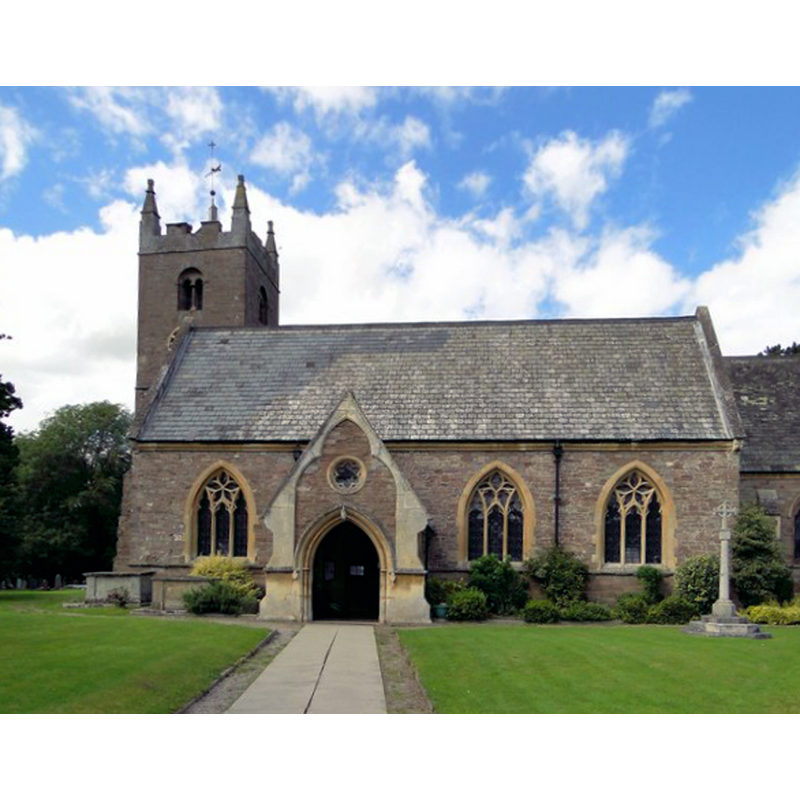
Image copyright © Philip Pankhurst, 2013
CC-BY-SA-2.0
Results: 3 records
view of church exterior - south view
Scene Description: Source caption: "St Mary, Tenbury Wells. Only the tower is relatively unaltered medieval work. Much of the church is by Henry Woodyer of 1864-5, replacing an 18th century rebuilding after flood damage, to which Tenbury is vulnerable to this day. The south porch is a typical Woodyer flourish."
Copyright Statement: Image copyright © Philip Pankhurst, 2013
Image Source: digital photograph taken 10 August 2013 by Philip Pankhurst [www.geograph.org.uk/photo/3594783] [accessed 29 October 2014]
Copyright Instructions: CC-BY-SA-2.0
view of font and cover in context
![Source caption: "The Henry Woodyer font, minus its original cover, now in the local museum." [NB: Henry Woodyer's 1864-1865]](/static-50478a99ec6f36a15d6234548c59f63da52304e5/compressed/1141101010_compressed.png)
Scene Description: Source caption: "The Henry Woodyer font, minus its original cover, now in the local museum." [NB: Henry Woodyer's 1864-1865]
Copyright Statement: Image copyright © Philip Pankhurst, 2013
Image Source: digital photograph taken 10 August 2013 by Philip Pankhurst [www.geograph.org.uk/photo/3594798] [accessed 29 October 2014]
Copyright Instructions: CC-BY-SA-2.0
view of church interior - nave - looking east
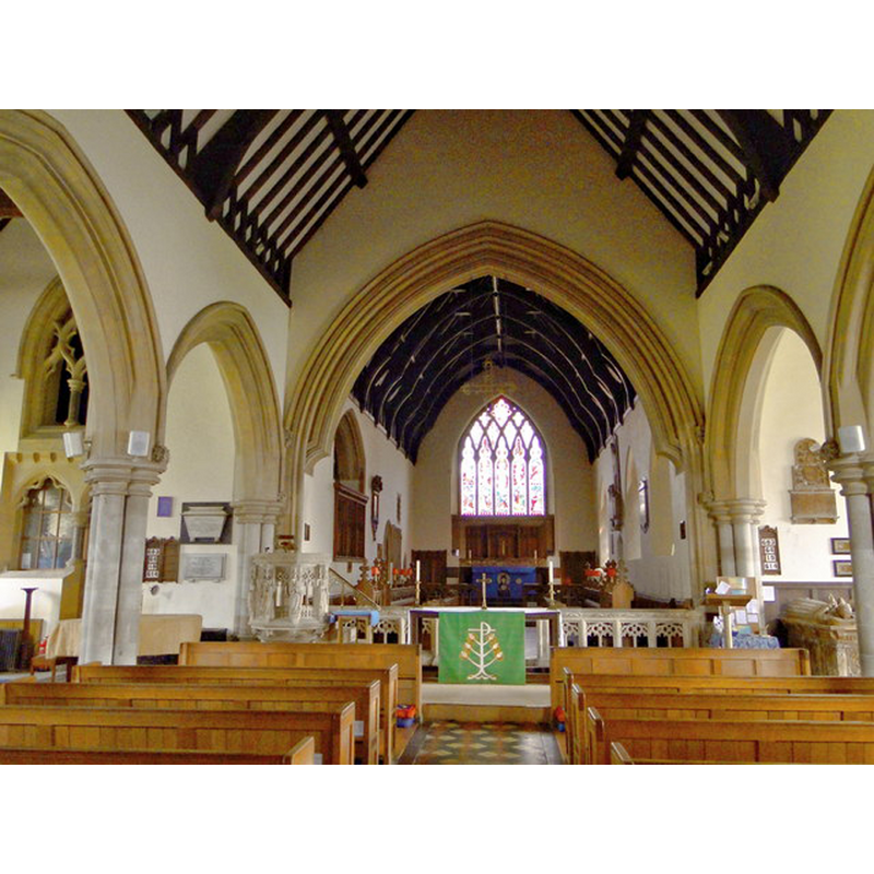
Copyright Statement: Image copyright © Philip Pankhurst, 2013
Image Source: digital photograph taken 10 August 2013 by Philip Pankhurst [www.geograph.org.uk/photo/3594785] [accessed 29 October 2014]
Copyright Instructions: CC-BY-SA-2.0
INFORMATION
Font ID: 16655TEN
Object Type: Baptismal Font1?
Font Century and Period/Style: 11th century, Pre-Conquest? / Norman
Church / Chapel Name: Parish Church of St. Mary the Virgin
Church Patron Saint(s): St. Mary the Virgin
Church Address: Church Street, Tenbury Wells, Worcestershire, WR15 8QE
Site Location: Worcestershire, West Midlands, England, United Kingdom
Directions to Site: Located on the A4112, just S of the A456 crossing and the river Teme, near the county border with Shropshire and Herefordshire
Ecclesiastic Region: Diocese of Worcester
Historical Region: Hundred of Doddingtree
Additional Comments: disappeared font? (the one from the Domesday-time church here)
Font Notes:
Click to view
There are two entries for Tenbury [variant spelling] in the Domesday survey [http://domesdaymap.co.uk/place/SO5968/tenbury-wells/] [accessed 29 October 2014], one of which reports a priest and churchlands in it. Miller (1890) reports the church, with the exception of the tower, destroyed by a great flood in 1770; since rebuilt; there is no mention of a font in it. The Victoria County History (Worcester, vol. 4, 1924) notes: "William Fitz Osbern Earl of Hereford gave half a hide of land at Tenbury to the church of St. Mary of Cormeilles. The church still held this land in 1086, when there was a priest, and therefore possibly a church, on the estate. [...] If the monks of Cormeilles had ever held Tenbury Church it must have passed out of their possession before the middle of the 12th century [...] The building has had a very chequered history owing to its proximity to the Teme, which, overflowing its banks at various periods, has caused great damage to the fabric. The tower dates from about the middle of the 12th century, and probably then adjoined a church consisting of a rectangular nave and small chancel similar to many of those in the neighbouring parishes [...] A disastrous flood in 1770 left the building practically a ruin and necessitated the entire rebuilding of the east and south walls of the south aisle and very considerable repair to the walls of the north aisle. [...] The church, after being restored in 1864, was again flooded to a considerable height in 1886"; the font is reported as being modern. The VCH entry (ibid.) includes also the Church of St. Michael and All Angels at nearby Berrington Heath, with a 19th-century "fine limestone font with a wood canopy". Brooks & Pevsner (2007) note that the baptismal font is by Henry Woodyer's 1864-1865 re-building of the church. [NB: we have no information on the earlier font(s) of this church]. [NB: a recent report from a local source [cf. Images area] reports the original 19th-century font cover by H. Woodyer as having been moved into museum; the present cover is plain and flat].
COORDINATES
UTM: 30U 527486 5795829
Latitude & Longitude (Decimal): 52.31211, -2.596812
Latitude & Longitude (DMS): 52° 18′ 43.6″ N, 2° 35′ 48.52″ W
REFERENCES
- Victoria County History [online], University of London, 1993-. URL: https://www.british-history.ac.uk.
- Brooks, Alan, Worcestershire, New Haven; London: Yale University Press, 2007, p. 630
- Miller, George [Revd.], The Parishes of the Diocese of Worcester, Birmingham: Hall & English, 1890, vol. 2: 313