Mathon / Mathene / Mathermayn / Mathin / Mathonaching / Mathum / Matma / Matme
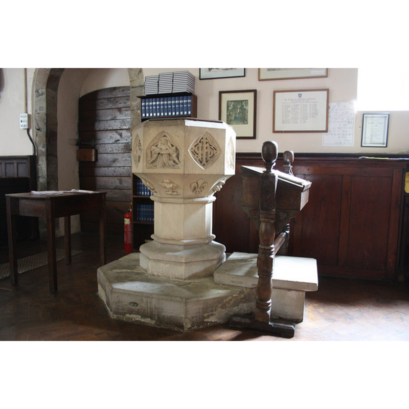
Image copyright © Bob Embleton, 2010
CC-BY-SA-2.0
Results: 5 records
view of font and cover
Scene Description: the modern font [cf. FontNotes]
Copyright Statement: Image copyright © Bob Embleton, 2010
Image Source: digital photograph taken 22 August 2010 by Bob Embleton [www.geograph.org.uk/photo/2027563] [accessed 15 October 2014]
Copyright Instructions: CC-BY-SA-2.0
view of basin - detail
![on one of the sides of the modern font [cf. FontNotes]](/static-50478a99ec6f36a15d6234548c59f63da52304e5/compressed/1141017007_compressed.png)
Scene Description: on one of the sides of the modern font [cf. FontNotes]
Copyright Statement: Image copyright © Bob Embleton, 2010
Image Source: digital photograph taken 22 August 2010 by Bob Embleton [www.geograph.org.uk/photo/2027609] [accessed 15 October 2014]
Copyright Instructions: CC-BY-SA-2.0
view of church exterior - southeast view
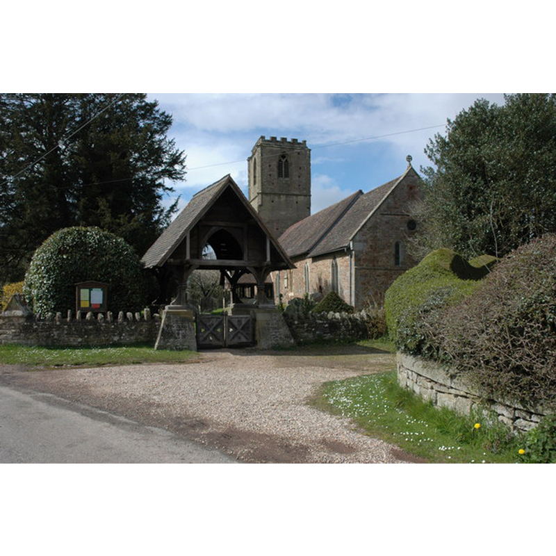
Copyright Statement: Image copyright © Philip Halling, 2008
Image Source: digital photograph taken 13 April 2008 by Philip Halling [www.geograph.org.uk/photo/775582] [accessed 15 October 2014]
Copyright Instructions: CC-BY-SA-2.0
view of church interior - nave - looking east
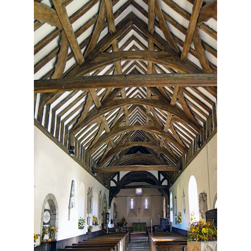
Scene Description: the top of the basin of the modern font is visible at the bottom-right corner of the image
Copyright Statement: Image copyright © Philip Halling, 2013
Image Source: digital photograph taken 6 October 2013 by Philip Pankhurst [www.geograph.org.uk/photo/3693217] [accessed 15 October 2014]
Copyright Instructions: CC-BY-SA-2.0
design element - motifs - foliage
![on the old font [now disappeared?]](/static-50478a99ec6f36a15d6234548c59f63da52304e5/others/image_not_available.jpg)
Scene Description: on the old font [now disappeared?]
![on the old font [now disappeared?]](/static-50478a99ec6f36a15d6234548c59f63da52304e5/bsi-testing-site/others/image_not_available.jpg)
INFORMATION
Font ID: 16560MAT
Object Type: Baptismal Font1
Font Century and Period/Style: Medieval
Church / Chapel Name: Parish Church of St. John the Baptist [St. Margaret's?]
Font Location in Church: [cf. FontNotes]
Church Patron Saint(s): St. John the Baptist [St. Margaret?]
Church Address: Mathon, Herefordshire WR13 5PW
Site Location: Herefordshire, West Midlands, England, United Kingdom
Directions to Site: Located between Malvern and Ledbury
Ecclesiastic Region: Diocese of Hereford
Historical Region: Hundred of Radlow [in Domesday] -- Hundred of Pershore -- formerly Worcestershire
Additional Comments: damaged font (the one reported here ca. 1848) -- disappeared font? (the one from the original Conquest-time church here)
Font Notes:
Click to view
There are five entries for Mathon [variant spelling] in the Domesday survey [http://domesdaymap.co.uk/place/SO7345/mathon/] [accessed 15 October 2014]; one of the parts in the tenancy of the Abbey of Pershore reports a priest but not a church, though there probably was one there. Noake (1848) writes: "There is an octagonal stone font which has received some rough usage, being split through; it has some foliated ornaments at the spring of the basin." Miller (1890) writes: "The Church of St. Margaret was made a vicarage ,1512. Church of St John Baptist contains [...]", which appears to suggest there were two churches in Mathon [cf. VCH entry infra]; Miller (ibid.) further comments on the Norman piscina and other work of that period at the east end of the church, but does not mention a font. The Victoria County History (Worcester, vol. 4, 1924) notes: "There was a priest in Mathon at the time of the Domesday Survey. [...] The church is mentioned about 1193 [...] About 1193 an arrangement was made between the patrons, the Abbot and convent of Pershore, and Peter, rector of the church, by which the abbot and convent received two parts of the great tithes and the rector the remainder with all the small tithes and the tithes of Farley. [...] The font is modern and of stone". A footnote in the VCH (ibid.) reads: "Bacon, Liber Regis, 978; Ecton, Thesaurus Rerum Eccl. 1742 and 1754. Nash (op. cit. ii, 174) says the invocation was to St. Margaret", therefore explaining Miller's apparent reference to two churches here [cf. supra]. The Parish website [www.mathon.org.uk/mathons-history/ralph-spencers-histories/the-old-community/the-church-st-john-baptist-mathon] [accessed 20 May 2010] informs: "the church was built at Mathon towards the end of the 11th Century [...] The stone altar in the sanctuary and the Norman font have not survived, and may have been destroyed". [NB: was the font reported in Noake [cf. supra] a medieval one?]
COORDINATES
UTM: 30U 541755 5773485
Latitude & Longitude (Decimal): 52.110329, -2.390267
Latitude & Longitude (DMS): 52° 6′ 37.18″ N, 2° 23′ 24.96″ W
MEDIUM AND MEASUREMENTS
Material: stone
Font Shape: octagonal, mounted
Basin Interior Shape: round
Basin Exterior Shape: octagonal
REFERENCES
- Victoria County History [online], University of London, 1993-. URL: https://www.british-history.ac.uk.
- Miller, George [Revd.], The Parishes of the Diocese of Worcester, Birmingham: Hall & English, 1890, vol. 2: 295
- Noake, John, The rambler in Worcestershire, or, Stray notes on churches and congregations, Worcester: Published and sold by all booksellers, 1848, p. 309