Romsley
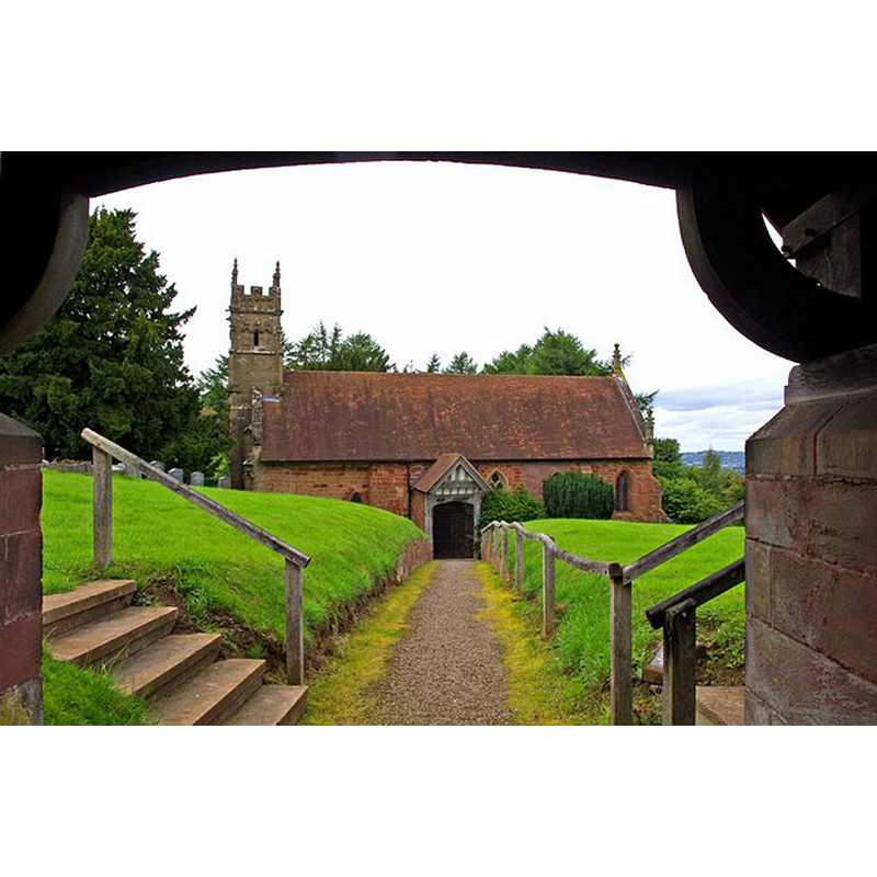
Image copyright © P L Chadwick, 2010
CC-BY-SA-2.0
Results: 2 records
view of church exterior in context - south view
Scene Description: Source caption: "St Kenelm's Church - viewed from the lychgate. The nave and chancel are 12th century. The Norman doorway on the south side is from around 1170. A doorway on the west side was blocked up at some point. The tower is late 15th century. The church was restored in 1845-46 by R C Hussey, and this included most internal detail, including the high-braced roof."
Copyright Statement: Image copyright © P L Chadwick, 2010
Image Source: digital photograph taken 22 August 2010 by P L Chadwick [www.geograph.org.uk/photo/2046237] [accessed 10 November 2014]
Copyright Instructions: CC-BY-SA-2.0
view of font in context

Scene Description: the modern font
Copyright Statement: Image copyright © Tudor Barlow, 2009
Image Source: digital photograph taken 22 August 2009 by Tudor Barlow [http://www.flickr.com/photos/tudorbarlow/3859255286/] [accessed 20 May 2010]
Copyright Instructions: PERMISSION NOT AVAILABLE -- IMAGE NOT FOR PUBLIC USE
INFORMATION
Font ID: 16556ROM
Object Type: Baptismal Font1?
Font Century and Period/Style: 11th - 12th century, Norman
Church / Chapel Name: Parish Church of St. Kenelm
Church Patron Saint(s): St. Kenelm [aka Cynehelm, Cynhelm, Kenelme]
Church Address: Chapel Lane, Romsley, Worcestershire, B62 0NG
Site Location: Worcestershire, West Midlands, England, United Kingdom
Directions to Site: Located 6-7 km S of Halesowen [aka Hales Owen]
Ecclesiastic Region: Diocese of Worcester
Additional Comments: disappeared font? (the one from the original church here)
Font Notes:
Click to view
Noakes (1852) reports: "an octagonal stone font, ornamented with quatrefoils, and having a conical covering of wood, crocketted". Miller (1890) writes: "The chapel was, in the Middle Ages, visited by many pilgrims [...] The old chapel, now the church, carries marks of great antiquity in the rude sculpture over the south door, though whether it dates from Saxon times is doubtful"; no font mentioned in it. Brooks & Pevsner (2007) report a Perpendicular-style font introduced by R.C. Hussey in his 1846-1847 restoration of the originally Norman church. The CRSBI (2014) writes of this church: "The plan of the foundations of St Kenelm's chapel suggests that it was built on a pre-Conquest base." [NB: we have no information on its medieval font].
COORDINATES
UTM: 30U 562322 5808642
Latitude & Longitude (Decimal): 52.424437, -2.083484
Latitude & Longitude (DMS): 52° 25′ 27.97″ N, 2° 5′ 0.54″ W
LID INFORMATION
Material: wood
Notes: [cf. FontNotes]
REFERENCES
- Brooks, Alan, Worcestershire, New Haven; London: Yale University Press, 2007, p. 580
- Corpus of Romanesque Sculpture in Britain and Ireland, The Corpus of Romanesque Sculpture in Britain and Ireland, The Corpus of Romanesque Sculpture in Britain and Ireland. URL: http://www.crsbi.ac.uk.
- Miller, George [Revd.], The Parishes of the Diocese of Worcester, Birmingham: Hall & English, 1890, vol. 2: 65-66
- Noake, John, The rambler in Worcestershire, or, Stray notes on churches and congregations, Worcester: Published and sold by all booksellers, 1848, p. 199