Montford / Maneford / Moneford
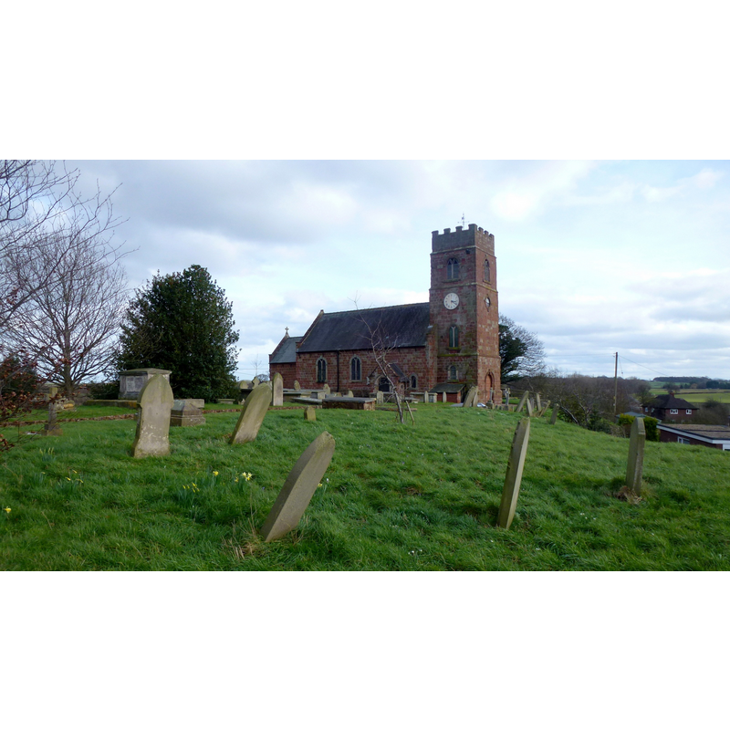
Image copyright © Jonathan Billinger, 2016
CC-BY-SA-2.0
Results: 1 records
view of church exterior - northwest view
Scene Description: Source caption: "St. Chad's church, Montford. Sandstone church on a low hill overlooking the Severn flood plain."
Copyright Statement: Image copyright © Jonathan Billinger, 2016
Image Source: digital photograph taken 3 March 2016 by Jonathn Billinger [www.geograph.org.uk/photo/4860468] [accessed 2 July 2020]
Copyright Instructions: CC-BY-SA-2.0
INFORMATION
Font ID: 16396MON
Object Type: Baptismal Font1?
Font Century and Period/Style: 13th century, Medieval
Church / Chapel Name: Parish Church of St. Chad
Font Location in Church: [cf. FontNotes]
Church Patron Saint(s): St. Chad [aka, Ceaadda, Cedd, Ceoddi]
Church Address: Monford Farm, Montford, Shrewsbury SY3 8EP, UK -- Tel.: +44 1743 851375
Site Location: Shropshire, West Midlands, England, United Kingdom
Directions to Site: Located off (S) the A5, N of the A458, 8-9 km WNW of Shrewsbury
Ecclesiastic Region: Diocese of Lichfield
Historical Region: Hundred of Baschurch
Additional Comments: disappeared font? (Eyton [cf. FontNotes] suggests a church here may have gone back as far as Domesday)
Font Notes:
Click to view
There is an entry for Montford [variant spelling] in the Domesday survey [https://opendomesday.org/place/SJ4114/montford/] [accessed 2 July 2020] but it mentions neither priest nor church in it. Eyton's Antiquities of Shropshire (vol. 10, 1860: 127-128) notes: "In whatever Saxon Parish Montford lay, at and before Domesday, it had an independent Church in the 13th century, and the Advowson thereof had passed to the White Nuns of Brewood, but whether by grant of a Lacy or a Fitz Alan I cannot learn. The Taxation of 1291, placing Moneford in the Deanery and Archdeaconry of Salop, values the Church at £5. 6s. 8d. per annum [...] Whether now, or within the next 40 years, the Brewood Nuns had an appropriation of the Rectory. [...] So far Montford Church was on a footing with other Churches of Lacy's Shropshire Fief; but it is further probable that the Churches thus charged were very ancient Foundations; -- nearly as old as Domesday". Anderson (1864) notes that a church is documented here in the 13th century. Newman & Pevsner (2006), however, note the 18th-century church "built on a medieval site"; no font mentioned. The entry for this church in Historic England [Listing NGR: SJ4188814776] notes: "There is known to have been a church on this site in the C13. A brief for the rebuilding of the church, for £1482, was issued in 1733-4. [...] [Present p]arish church. 1735-8, by William Cooper of Shrewsbury, restored and porch added in 1884. [...] C19 octagonal painted stone font with step and iron-bound wooden cover." [NB: we have no information on the font of the medieval church here]
COORDINATES
UTM: 30U 509340 5841975
Latitude & Longitude (Decimal): 52.72757, -2.8617
Latitude & Longitude (DMS): 52° 43′ 39.25″ N, 2° 51′ 42.12″ W
REFERENCES
- Anderson, John Corbet, Shropshire, its early history and antiquities, comprising […], London: Willis and Sotheran, 1864, p. 429
- Eyton, Robert William, The Antiquities of Shropshire, London: John Russell Smith, 1856-, vol. 10: 127-129
- Newman, John, Shropshire, New Haven: Yale University Press, 2006, p. 409