Martindale
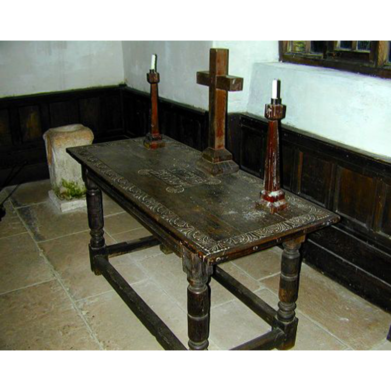
Image copyright © David Hickson, 2001
Permission received (e-mail of 6 February 2010)
Results: 4 records
view of stoup in context
Copyright Statement: Image copyright © David Hickson, 2001
Image Source: digital photograph [2001?] by David Hickson [www.gardenhousenursery.co.uk/htmfile/martindale.html] [accessed 30 January 2010]
Copyright Instructions: Permission received (e-mail of 6 February 2010)
view of church exterior - southwest view

Copyright Statement: Image copyright © Julian Thurgood, 2010
Image Source: digital photograph in Julian Thurgood [www.visitcumbria.com/pen/chp20.htm] [accessed 30 January 2010]
Copyright Instructions: PERMISSION [requested] NOT AVAILABLE -- IMAGE NOT FOR PUBLIC USE
view of church interior - nave - looking east
Scene Description: the square stoup visible at the northeast end of the nave
Copyright Statement: Image copyright © Julian Thurgood, 2010
Image Source: digital photograph in Julian Thurgood [www.visitcumbria.com/pen/chp20.htm] [accessed 30 January 2010]
Copyright Instructions: PERMISSION [requested] NOT AVAILABLE -- IMAGE NOT FOR PUBLIC USE
view of stoup
Copyright Statement: Image copyright © StProc2009, 2007
Image Source: digital photograph taken 20 October 2007 by StProc2009 [www.flickr.com/photos/stproc/3876678283/] [accessed 30 January 2010]
Copyright Instructions: PERMISSION NOT AVAILABLE -- IMAGE NOT FOR PUBLIC USE
INFORMATION
Font ID: 15915MAR
Object Type: Stoup?
Object Details: altar, Roman
Font Century and Period/Style: 3rd - 5th century [altered], Anglo-Roman [altered]
Church / Chapel Name: Old Church / Chapel of St. Martin
Font Location in Church: Inside the church, in the NE corner of the nave
Church Patron Saint(s): St. Martin of Tours
Church Address: Martindale, Cumbria, CA102NF
Site Location: Cumbria, North West, England, United Kingdom
Directions to Site: Located off (E) the A592, on the E bank of Ullswater, NE of Patterdale. The old church, St. Martin's, is about 1/2 a mile from the 19th-century church of St. Peter
Ecclesiastic Region: Diocese of Carlisle
Historical Region: formerly North Westmoreland
Additional Comments: re-cycled Roman altar? / Roman pillar? / used as sharpening tool
Font Notes:
Click to view
Cox (1913) mentions a "14th cent. upstanding holy-water stoup at Martindale". Curwen (1932) mentions that this "chapel" is documented to 1220 and 1247, and that it was "consecrated with parochial rights" after its re-building in 1633. Curwen (ibid.) adds: "The building underwent complete repair in 1833, but is now disused." Julian Thurgood [www.visitcumbria.com/pen/chp20.htm] [accessed 30 January 2010] notes: "The old Church of St Martin, Martindale, has existed since at least 1220. It is probable that the present building was erected at the end of the 16th Century. There have been successive restorations to the present building, the last major restoration being in 1882 [...] Objects of interest include [...] the font which was almost certainly a Roman altar". [NB: the object is alternatively described as a stoup or a font in the local sources; this old church is open only occassionally in the summer; most services are carried out at the new, 19th-century, church of St. Peter nearby]. Hickson (2001), in his website on Martindale [http://www.gardenhousenursery.co.uk/htmfile/martindale.html] [accessed 30 January 2010] notes and ilustrates the font: "In the corner next to the altar is a stone font which apparently was brought down from the Roman road of High Street which ran along the fell tops. This font was originally a standing stone believed to be at least 1700 years old. It was originally used by the locals to sharpen tools but was later hollowed out and used as a font. The marks from the tool sharpening are still visible."
Credit and Acknowledgements: We are grateful to David Hickson, of Martindale, Cumbria, for the photograph of this object
COORDINATES
UTM: 30U 508006 6045582
Latitude & Longitude (Decimal): 54.5577, -2.8762
Latitude & Longitude (DMS): 54° 33′ 27.72″ N, 2° 52′ 34.32″ W
MEDIUM AND MEASUREMENTS
Material: stone
Font Shape: square
Basin Interior Shape: round
Basin Exterior Shape: square
REFERENCES
- Cox, John Charles, Cumberland and Westmorland, London: George Allen & Co. Ltd., 1913, p. 15
- Curwen, John F., The Later Records relating to North Westmorland: or the Barony of Appleby, Kendal: T. Wilson, 1932, p. 256-277 / [www.british-history.ac.uk/report.aspx?compid=43518] [accessed 9 September 2014]