Tattenhoe / Tattenhall / Tattenho / Thateo / Totenho / Tottenhoe / Tottynho
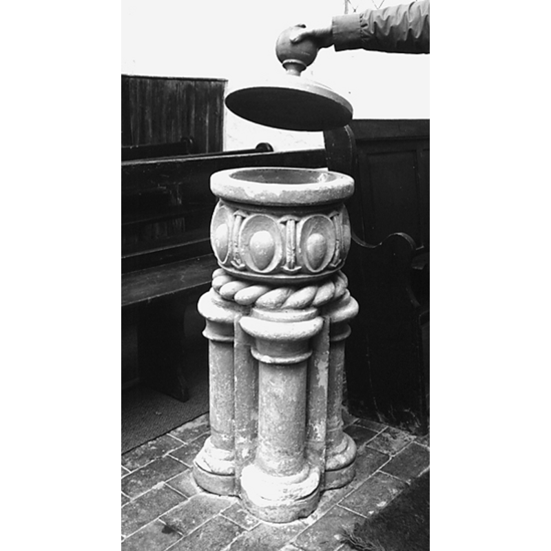
Image copyright © Laurence Meering, 2009
Permission received (e-mail form Laurence Meering received 22 February 2010)
Results: 2 records
view of font and cover
Copyright Statement: Image copyright © Laurence Meering, 2009
Image Source: photograph taken by Laurence Meering 23 May 2009, in 'A short history of Newton Longville' [http://www.newton-longville.co.uk/html/village_history.html] [accessed 13 January 2010]
Copyright Instructions: Permission received (e-mail form Laurence Meering received 22 February 2010)
view of church exterior - south view
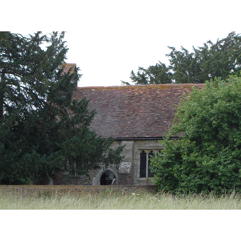
Copyright Statement: Image copyright © [in the public domain]
Image Source: digital photograph taken 23 June 2006 by Guydrury [https://en.wikipedia.org/wiki/File:StGilesChurchTattenhoe1.JPG] [accessed 23 November 2015]
Copyright Instructions: Released by its author into the public domain
INFORMATION
Font ID: 15830TAT
Object Type: Baptismal Font1
Font Century and Period/Style: 13th century [base only] [composite font], Medieval [composite]
Church / Chapel Name: Parish Church of St. Giles
Font Location in Church: Inside the church
Church Patron Saint(s): St. Giles [aka Aegidus, Egidus, Gilles]
Site Location: Buckinghamshire, South East, England, United Kingdom
Directions to Site: Located in the SW area of Milton Keynes, 5 km WNW of Fenny Stratford
Ecclesiastic Region: Diocese of Oxford
Additional Comments: altered font / re-cycled font / composite font / painted font (to imitate marble [cf. FontNotes]) -- disappeared font? (was there a font at the 12thC chapel of Tattenhoe?)
Font Notes:
Click to view
No entry found for Tattenhoe in the Domesday survey. Sheahan (1862) writes: "The font is an octagonal-shaped vase of free stone, which, like the pedestal that supports it (consisting of four circular pillars) is well carved and wrought, like the cornice or capital of a pillar, with the egg and anchor ornament. It is painted to represent marble". The Victoria County History (Buckingham, vol. 3, 1925) notes: "Sibyl de Angerville, grandmother of Ralph Martel, granted the place called Snelshall (locum de Snelleshal) and the chapel of Tattenhoe to the monastery of Lavendon in the 12th century [...] The [present] church of St. Giles […] was built in 1540 from some of the remains of Snelshall Priory in the adjoining parish of Whaddon. It would appear to have been disused for a time in the 17th century […] In 1892 the church was restored […] The carved octagonal bowl of the font is modern, but the base is probably of the 13th century and consists of four grouped shafts with moulded capitals and bases, all painted." A font somewhat meeting the description in the VCH is illustrated in 'A short history of Newton Longville' by Roger Martin and Jimmy Bates [www.newton-longville.co.uk/html/village_history.html] [accessed 13 January 2010]. The font appears now as a composite object of awkward presence: the narrow round basin with moulded and decorated sides appears to sit on a thick rope moulding [not clear which part this belongs to, basin or base], on a cluster of four round columns with moulded capitals and bases; this columnar base appears to be of typical 13th-century design and execution, and is most likely of the Early English period, as suggested in th VCH [NB: not clear whether the octagonal basin noted in the VCH was replaced by the present round one, or it is the same one re-carved]. The Parish website [http://www.parishes.oxford.anglican.org/tattenhoe/history.htm] [accessed 13 January 2010] notes: "In 1538 Henry VIII ordered Snelshall Priory to be closed and demolished. Some of the stones were transported and used to rebuild St Giles’. Parts of today’s St Giles’ are still recognisable as part of an earlier building - including the archway of the main door and the base of our font."
Credit and Acknowledgements: We are grateful to Rev. Laurence Meering for his photograph of this font
COORDINATES
UTM: 30U 651455 5763092
Latitude & Longitude (Decimal): 51.9978, -0.7938
Latitude & Longitude (DMS): 51° 59′ 52.08″ N, 0° 47′ 37.68″ W
MEDIUM AND MEASUREMENTS
Material: stone
Font Shape: round, mounted
Basin Interior Shape: round
Basin Exterior Shape: round
LID INFORMATION
Date: modern
Material: wood
Apparatus: no
Notes: round and flat with a large knob
REFERENCES
- Victoria County History [online], University of London, 1993-. URL: https://www.british-history.ac.uk.
- Sheahan, James Joseph, History and topography of Buckinghamshire, comprising a general survey of the county, preceded by an epitome of the early history of Great Britain, London; Pontefract: Longman, Green, Longman, and Roberts; William Edward Bonas [...], 1862, p. 760