Heath nr. Chesterfield / Lowne / Lund / Lune
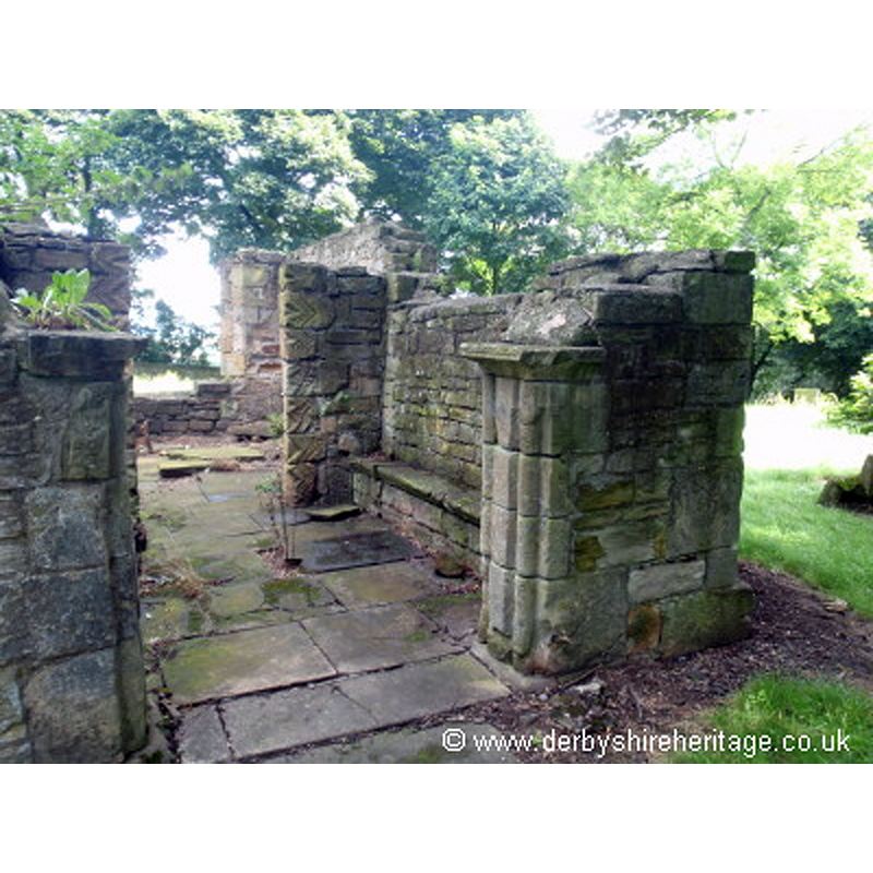
Image copyright © Derbyshire Heritage, 2015
No known copyright restriction / Fair Dealing
Results: 3 records
view of church exterior
Scene Description: the ruins of the old church, after its use as funerary chapel
Copyright Statement: Image copyright © Derbyshire Heritage, 2015
Image Source: digital photograph in Derbyshire Heritage [www.derbyshireheritage.co.uk/Menu/Buildings/Churches/Heath Old Church entrance.jpg] [accessed 1 September 2015]
Copyright Instructions: No known copyright restriction / Fair Dealing
view of church exterior - southeast view
Scene Description: Source caption: "Dedicated to All Saints, Heath church in Derbyshire was built in 1852. In the porch are some Coffin slabs, one dating from the 11 or 12th century, which came from the ruins of the old church a 1/4 of a mile away."
Copyright Statement: Image copyright © David Rogers, 2009
Image Source: digital photograph taken 15 April 2009 by David Rogers [www.geograph.org.uk/photo/1254004] [accessed 1 September 2015]
Copyright Instructions: CC-BY-SA-2.0
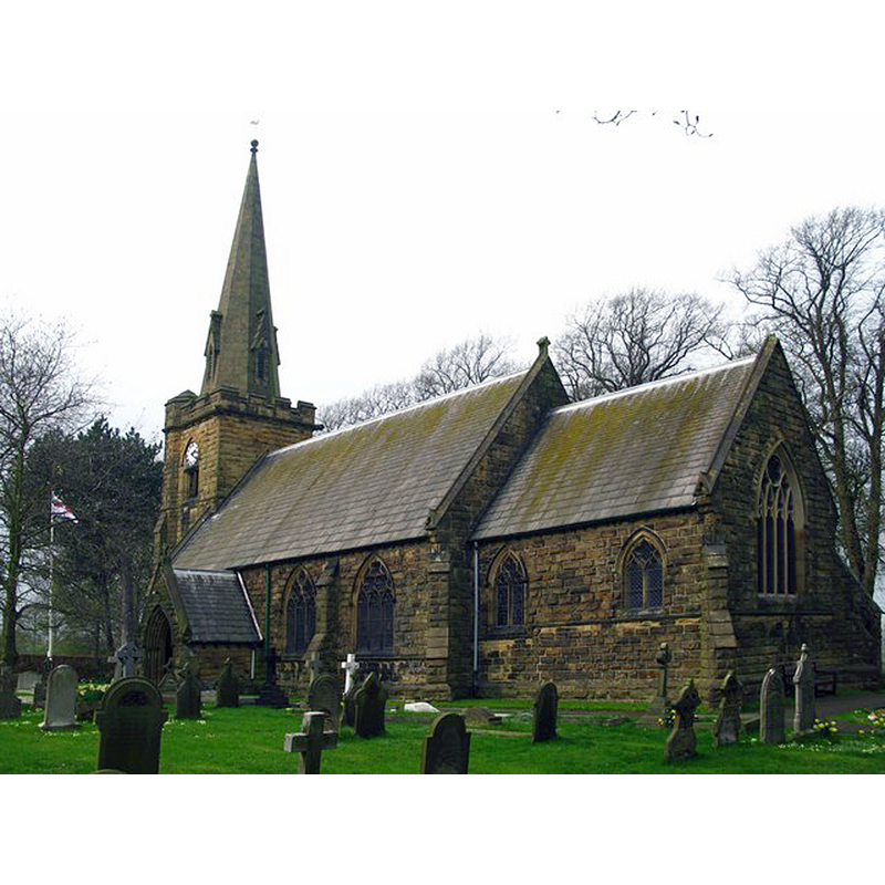
view of church exterior - south view
![the 1853 church by Stevens; restored 1882-6 by Butterfield [cf. FontNotes]](/static-50478a99ec6f36a15d6234548c59f63da52304e5/compressed/1150901066_compressed.png)
Scene Description: the 1853 church by Stevens; restored 1882-6 by Butterfield [cf. FontNotes]
Copyright Statement: Image copyright © Nigel Coates, 2010
Image Source: digital photograph taken 25 September 2010 by Nigel Coates [https://commons.wikimedia.org/wiki/File:All_Saints_Church_Heath_2_(Nigel_Coates).jpg] [accessed 1 September 2015]
Copyright Instructions: CC-BY-SA-3.0
INFORMATION
Font ID: 15814HEA
Object Type: Baptismal Font1?
Font Century and Period/Style: 11th - 12th century, Medieval
Church / Chapel Name: Old Parish Church of All Saints [demolished in 1852]
Font Location in Church: [cf. FontNotes]
Church Patron Saint(s): All Saints
Church Notes: ruins of 11th-12thC church are located 400 m. from the present one; it became a funerary chapel in the 17thC; in ruins since mi-19thC [illustrated page at http://www.derbyshireheritage.co.uk/Menu/Buildings/Churches/heath-old-church.php [accessed 1 September 2015]
Church Address: address of the ruins of old church: A6175, Heath, Derbyshire S44 5SJ / new church address: Church Lane, Heath, Derbyshire S44 5SD
Site Location: Derbyshire, East Midlands, England, United Kingdom
Directions to Site: Located off the A617 and the M1, 8 km SE of Chesterfield
Ecclesiastic Region: Diocese of Derby
Additional Comments: disappeared font? (the one from the ruined 11th-12thC church here)
Font Notes:
Click to view
No entry found for Heath in the Domesday survey. Cox (1875) informs that the older church, that existed to the east of the village, was pulled down in 1852, "and the new one built in the midst of the village […] The round stone font of the former church has recently been placed in this chapel, but the mouldings show it to be of post-Reformation date". The entry for the ruins of the old church here in English Heritage [Listing NGR: SK4523067108] (1967) reads: "Fragmentary ruins of church. C12 and later, of indeterminate date. Sandstone rubble with sandstone dressings. Two cell plan, probably remodelled into a chapel with porch in the C19 as the axis is north to south. Roofless and the walls incomplete. Remains of lower parts of jambs to north window. Stone seats in the porch. Remains of jambs to a south doorway with very weathered C12 chevron decoration. The south east jamb survives to about four feet, the south west jamb only to about two feet. Outer doorway jambs with roll moulding. Dressed quoins.] The entry for the later church [Listing NGR: SK4482267079] (1984) reads: "Church. 1853 by H.I.Stevens. Restored 1882-6 by William Butterfield", and reports "two C11 or C12 coffin slabs, one rectangular with incised motifs, the other tapering to the base, with a cross and figure", in the porch of the new church, believed to be originally from the old church. [NB: we have no information on the font of the disappeared 11th-12th century church here].
COORDINATES
UTM: 30U 611539 5895700
Latitude & Longitude (Decimal): 53.198915, -1.33023
Latitude & Longitude (DMS): 53° 11′ 56.09″ N, 1° 19′ 48.83″ W
MEDIUM AND MEASUREMENTS
Material: stone
REFERENCES
- Cox, John Charles, 1875-1877