Dallinghoo / Dalingahou / Dalingehou / Dallingahou / Dallinghoe / Delingahou
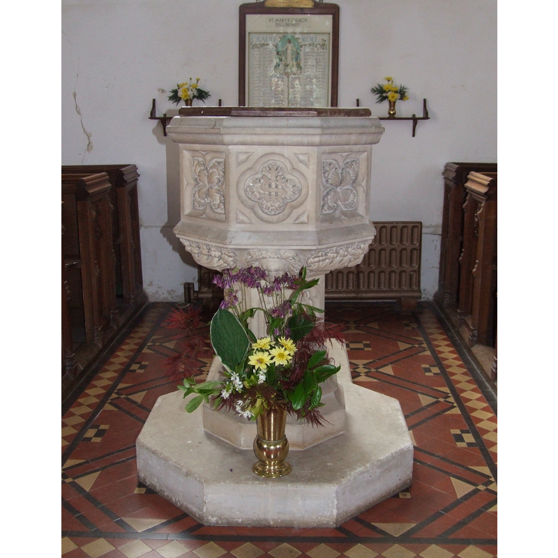
Image copyright © Simon Knott, 2008
Standing permission
Results: 2 records
view of font and cover
Scene Description: the modern font [cf. Font notes]
Copyright Statement: Image copyright © Simon Knott, 2008
Image Source: digital photograph taken 27 May 2008 by Simon Knott [http://www.suffolkchurches.co.uk/dallinghoo.html] [accessed 29 October 2009]
Copyright Instructions: Standing permission
view of church exterior - south view
![Source caption: "St Mary's church, Dallinghoo. It dates from the late C11/early C12 with C14 and C15 additions." -- "The eastern chancel is now demolished and the base of the tower serves as a chancel" [cf. FontNotes]](/static-50478a99ec6f36a15d6234548c59f63da52304e5/compressed/1231120001_compressed.png)
Scene Description: Source caption: "St Mary's church, Dallinghoo. It dates from the late C11/early C12 with C14 and C15 additions." -- "The eastern chancel is now demolished and the base of the tower serves as a chancel" [cf. FontNotes]
Copyright Statement: Image copyright © Bikeboy, 2015
Image Source: digital photograph 29 October 2015 by Bikeboy [https://commons.wikimedia.org/wiki/File:St_Mary's_church,_Dallinghoo_-_geograph.org.uk_-_4791891.jpg
Copyright Instructions: CC-BY-SA-2.5
INFORMATION
Font ID: 15632DAL
Object Type: Baptismal Font1
Font Century and Period/Style: 14th - 15th century, Medieval
Church / Chapel Name: Parish Church of St. Mary
Font Location in Church: [cf. FontNotes]
Church Patron Saint(s): St. Mary the Virgin
Church Address: Church Rd, Dallinghoo, Woodbridge IP13 0JY, United Kingdom -- Tel.: +44 1728 685308
Site Location: Suffolk, East Anglia, England, United Kingdom
Directions to Site: Located off (S) the B1078, 4 km W of Wickham Market, 6 km N of Woodbridge
Ecclesiastic Region: Diocese of St Edmundsbury & Ipswich
Historical Region: Hundred of Loose [in Domesday]
Additional Comments: disappeared font? / replaced font? (a Domesday entry reports a church in it)
Font Notes:
Click to view
There are eight entries for Dalinghoo [variant spellings] in the Domesday survey [https://opendomesday.org/place/TM2654/dallinghoo/] [accessed 19 November 2023]; of the eight, the entry for Count Alan of Brittsny reports "1 church. 0.24 church lands" in it. Parker (1855) reports an octagonal font "with panelled bowl" in this church. The present font, illustrated in Knott (2008), is modern and must be the one reported in Kelly's Directory of 1883: "the handsome carved stone font was erected by the parishioners in 1868". The entry for this church in Historic England [Listing NGR: TM2660654979] notes: "Church. Late Cll/early C12 with early C14 and C15 and C19 additions and alterations [...] The eastern chancel is now demolished and the base of the tower serves as a chancel"; it mentions no font in it. [NB: we have no information on the panelled font noted in Parker]
COORDINATES
UTM: 31U 384499 5778621
Latitude & Longitude (Decimal): 52.146, 1.312
Latitude & Longitude (DMS): 52° 8′ 45.6″ N, 1° 18′ 43.2″ E
MEDIUM AND MEASUREMENTS
Material: stone
Font Shape: octagonal, mounted
Basin Interior Shape: round
Basin Exterior Shape: octagonal
REFERENCES
- Kelly, Kelly's Directory for Cambridge, Norfolk & Suffolk, London: Kelly's Directories Ltd., 1883, p. 861
- Knott, Simon, The Suffolk Churches Site, Simon Knott, 1999-. [standing permission to reproduce images received from Simon [February 2005]. URL: www.suffolkchurches.co.uk.
- Parker, John Henry, The Ecclesiastical and architectural topography of England [...] Suffolk, 1855, [unpaged]