Meare No. 2 / Ferlingmere / Ferramere / Mere
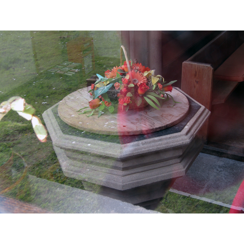
Image copyright © Colin Smith, 2022
Image and permission received from the author (e-mail of 8 October 2022)
Results: 4 records
design element - motifs - moulding
Scene Description: [cf. Font notes]
Copyright Statement: Image copyright © Colin Smith, 2022
Image Source: digital photograph 30 March 2022 by Colin Smith
Copyright Instructions: Image and permission received from the author (e-mail of 8 October 2022)
view of church exterior - southeast view
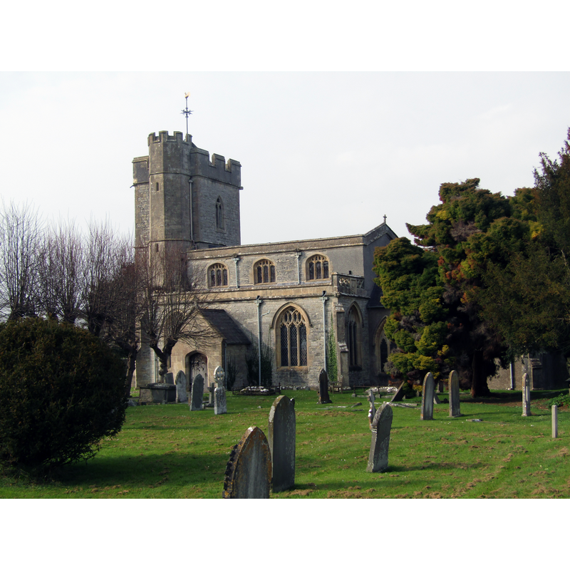
Copyright Statement: Image copyright © Colin Smith, 2022
Image Source: digital photograph 30 March 2022 by Colin Smith
Copyright Instructions: Image and permission received from the author (e-mail of 8 October 2022)
view of church interior - nave - looking east
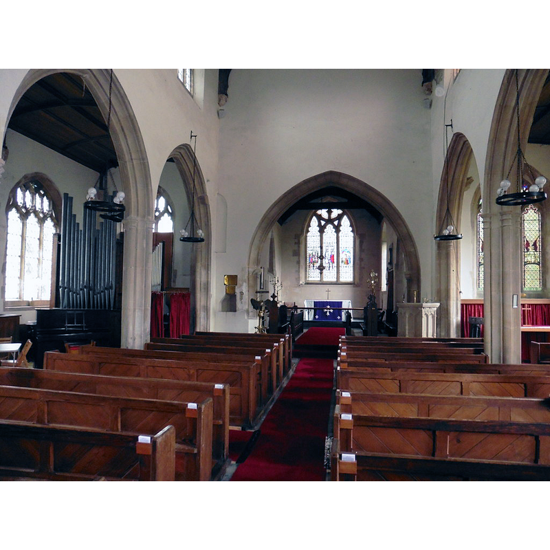
Copyright Statement: Image copyright © Roger Cornfoot, 2017
Image Source: digital photograph taken 29 March 2017 by Roger Cornfoot [www.geograph.org.uk/photo/5330766] [accessed 8 May 2018]
Copyright Instructions: CC-BY-SA-2.0
design element - motifs - moulding
![[cf. Font notes]](/static-50478a99ec6f36a15d6234548c59f63da52304e5/others/permission_not_available.jpg)
Scene Description: [cf. Font notes]
Copyright Statement: Image copyright © Peter, 2010
Image Source: digital photograph taken 9 February 2010 by Peter [www.flickr.com/photos/10350073@N04/4346369820/]
Copyright Instructions: PERMISSION NOT AVAILABLE -- IMAGE NOT FOR PUBLIC USE
INFORMATION
Font ID: 15378MEA
Object Type: Baptismal Font1
Font Century and Period/Style: 15th century / 19th century, Perpendicular? / Modern?
Church / Chapel Name: Parish Church of St. Mary
Font Location in Church: Inside the church
Church Patron Saint(s): St. Mary the Virgin
Church Address: St Mary's Road, Meare BA6 9TH , UK -- Tel.: +44 1458 834281
Site Location: Somerset, South West, England, United Kingdom
Directions to Site: Located on the B3151, 8-10 km WNW of Glastonbury
Ecclesiastic Region: Diocese of Bath & Wells
Historical Region: Hundred of Glastonbury Twelve Hides -- Hundred of Whitley [in Domesday]
Additional Comments: modern font? / re-tooled font? [cf. FontNotes]
Font Notes:
Click to view
There is an entry for Meare [variant spelling] in the Domesday survey [http://opendomesday.org/place/ST4541/meare/] [accessed 8 May 2018], but it mentions neither cleric nor church in it. Phelps (1836) notes: "An ancient Anglo-Norman font was removed, and still exists, and a more modern one introduced when the church was enlarged." Pevsner (1958), in his entry for Croscombe, mentions the fonts at Meare and Weston Zoyland as sharing the "series of heavy horizontal mouldings"; Pevsner's entry for Meare (ibid.) reports the font as Perpendicular, of an unusual design. The entry for this church in Historic England [www.imagesofengland.org.uk/details/default.aspx?id=267766] [accessed 8 May 2018] reports an "Octagonal Decorated font with a series of bold mouldings" in this church, and does not mention an earlier font in it. The entry for this parish in the Victoria County History (Somerset, vol. 9, 2006) notes: "A spurious charter of King Edgar, dated 971 and recorded by William of Malmesbury in the 12th century, alludes to chapels on the islands of Meare, Godney, and Marchey. These capellae were expressly distinguished from the ancient parish churches (ecclesiae parochiales) and their dependencies but like them were under the special jurisdiction of the abbot of Glastonbury and outside the control of the bishop. [...] That at Meare presumably became the parish church of St. Mary. [...] The parish church of St. Mary was consecrated in 1323 in the name of the Blessed Virgin Mary, All Saints, and especially St. Benignus, presumably after the building of the nave, chancel, and embattled west tower. [...] A font, described as Norman, [...] was replaced before 1839 by one in Perpendicular style". The VCH entry (ibid.) further notes: " A plain stone bowl removed from the fish house to Wells Museum in 1933 has been described as a Saxon font: ch. guide (n.d.) but was possibly for salting fish: inf. from Wells Museum." The present font consists of an octagonal basin on an octagonal base, all covered in parallel mouldings; the font has a definitely modern look, and it is not clear to us whether it is a modern font or an older one drastically re-tooled.
Credit and Acknowledgements: We are garteful to Colin Smith for his photographs of this church and font
COORDINATES
UTM: 30U 515457 5668953
Latitude & Longitude (Decimal): 51.1718, -2.7789
Latitude & Longitude (DMS): 51° 10′ 18.48″ N, 2° 46′ 44.04″ W
MEDIUM AND MEASUREMENTS
Material: stone
Font Shape: octagonal, mounted
Basin Interior Shape: round
Basin Exterior Shape: octagonal
Drainage Notes: lining
LID INFORMATION
Date: moder
Material: wood
Apparatus: no
Notes: round, flat and plain
REFERENCES
- Victoria County History [online], University of London, 1993-. URL: https://www.british-history.ac.uk.
- Pevsner, Nikolaus, North Somerset and Bristol, Harmondsworth: Penguin Books, 1958, p. 179
- Pevsner, Nikolaus, South and West Somerset, Harmondsworth: Penguin Books, 1958, p. 234