West Lydford / Lideford / Lydford-on-Fosse
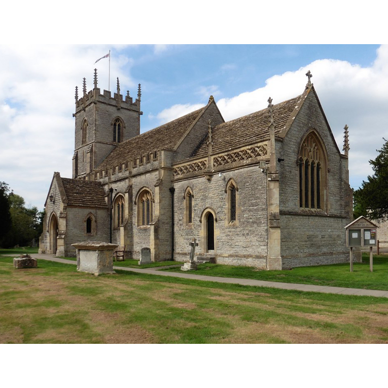
Image copyright © Roger Cornfoot, 2018
CC-BY-SA-2.0
Results: 2 records
view of church exterior - southeast view
Copyright Statement: Image copyright © Roger Cornfoot, 2018
Image Source: digital photograph taken 5 September 2018 by Roger Cornfoot [www.geograph.org.uk/photo/5896474] [accessed 23 December 2018]
Copyright Instructions: CC-BY-SA-2.0
design element - architectural - niche - 8
![on the sides of the stem [cf. FontNotes]](/static-50478a99ec6f36a15d6234548c59f63da52304e5/others/image_not_available.jpg)
Scene Description: on the sides of the stem [cf. FontNotes]
![on the sides of the stem [cf. FontNotes]](/static-50478a99ec6f36a15d6234548c59f63da52304e5/bsi-testing-site/others/image_not_available.jpg)
INFORMATION
Font ID: 15367LYD
Object Type: Baptismal Font1
Font Century and Period/Style: 15th century, Perpendicular
Church / Chapel Name: Parish Church of St. Peter / St. Mary
Font Location in Church: [cf. FontNotes]
Church Patron Saint(s): St. Peter / St. Mary and All Saints
Church Address: High St, West Lydford, Somerton TA11 7DB, UK -- Tel.: 01458 223237
Site Location: Somerset, South West, England, United Kingdom
Directions to Site: Located off (W) the A37, N of the B3153, 10 km W of Castle Cary, 15 km SW of Shepton Mallet
Ecclesiastic Region: Diocese of Bath & Wells
Historical Region: Hundred of Catsash -- Hundred of Blachethorna [in Domesday]
Additional Comments: disappeared font? (the one from the 12thC church here)
Font Notes:
Click to view
There is an entry for [West] Lydford [variant spelling] in the Domesday survey [http://opendomesday.org/place/ST5631/west-lydford/] [accessed 5 February 2018], but it mentions neither cleric nor church in it. Kelly's Directory of 1883 notes the Church of St. Mary, "rebuilt in 1846" and remarks that "the font has been removed". The entry for this parish in the Victoria County History (Somerset, vol. 10, 2010) entry for this parish notes: "The church was in existence by the mid 12th century [...] the church was dedicated to St Mary and All Saints in 1482, although now known as St Peter [...] The [present] church of St Peter lies immediately north of the river Brue in an area prone to flooding, within a roughly rectangular east-west churchyard, It replaced the medieval church, which was demolished in 1844. That church may have been the result of a major rebuilding programme c. 1333 [...] further alteration after 1333. The Perpendicular windows to nave and the belfry openings appear 15th-century rather than 14th, possibly altered when the north aisle and perhaps a south porch were added. The north arcade piers may have been reused in the rebuilt church, as was the 15th-century font [...] In July 1844 the church was demolished, apart from the tower, which was restored with additional pinnacles. A new church with chancel, nave, north aisle, south porch, and west tower was built on the same site and to almost the same plan of blue lias with Doulting dressings to designs in Somerset Perpendicular style by Benjamin Ferrey." An edition of Harvey Pridham’s Survey of Somerset Church Fonts was published in 2013 by The Somerset Archaeological and Natural History Society (SANHS), which claims to have a drawing of the West Lydford in it [http://www.sanhs.org/Documents/Fonts.pdf] [accessed 5 February 2017] [BSI does not have access to it yet]. The entry for this church in Historic England [Listing NGR: ST5647531881] notes: "Anglican Parish Church. 1846 by B. Ferrey on an earlier site. [...] Archaeologically correct Perpendicular. [...] Plain C15 octagonal font, a niche to each face of its base."
COORDINATES
UTM: 30U 526413 5659300
Latitude & Longitude (Decimal): 51.0846, -2.6229
Latitude & Longitude (DMS): 51° 5′ 4.56″ N, 2° 37′ 22.44″ W
MEDIUM AND MEASUREMENTS
Material: stone
Font Shape: octagonal, mounted
Basin Interior Shape: round
Basin Exterior Shape: octagonal
REFERENCES
- Victoria County History [online], University of London, 1993-. URL: https://www.british-history.ac.uk.
- Kelly, Eric Robert, Kelly's Directory of Somersetshire with the city of Bristol, London: Kelly & Co., 1883, p. 255
- Pridham, Harvey, Ancient fonts of Somerset, Somerset: Somerset Archaeological and Natural Society, 2013