Ansford / Almsford / Almundesford
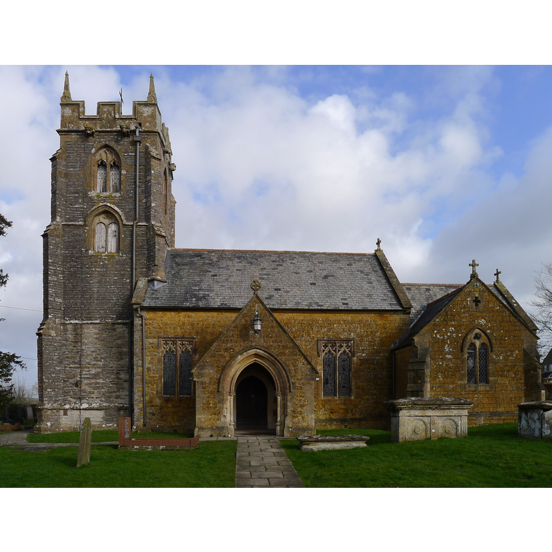
Image copyright © Tim Heaton, 2014
CC-BY-SA-2.0
Results: 3 records
view of church exterior - south view
Scene Description: EXT S digital photograph taken 27 February 2014 by Tim Heaton [www.geograph.org.uk/photo/3903415] [accessed 31 January 2018] Source caption: "Church of St Andrew, Ansford. 15th century tower, the remainder rebuilt in the 19th century".
Copyright Statement: Image copyright © Tim Heaton, 2014
Image Source: edited detail of a digital photograph taken 27 February 2014 by Tim Heaton [www.geograph.org.uk/photo/3903415] [accessed 31 January 2018]
Copyright Instructions: CC-BY-SA-2.0
view of font

Scene Description: only the basin is original
Copyright Statement: Image copyright © CRSBI, 2018
Image Source: digital image of a photograph by Robin Downes, in the CRSBI [www.crsbi.ac.uk/site/148/] [accessed 31 January 2018]
Copyright Instructions: PERMISSION NOT AVAILABLE -- IMAGE NOT FOR PUBLIC USE
view of basin - upper view
Scene Description: notice the metal plugs for the anchoring of the old font cover; the one at the back split the stone
Copyright Statement: Image copyright © CRSBI, 2018
Image Source: digital image of a photograph by Robin Downes, in the CRSBI [www.crsbi.ac.uk/site/148/] [accessed 31 January 2018]
Copyright Instructions: PERMISSION NOT AVAILABLE -- IMAGE NOT FOR PUBLIC USE
INFORMATION
Font ID: 15293ANS
Object Type: Baptismal Font1
Font Century and Period/Style: 12th - 13th century [basin only], Medieval / composite
Church / Chapel Name: Parish Church of St. Andrew
Font Location in Church: Inside the church, in the N aisle
Church Patron Saint(s): St. Andrew
Church Notes: original church late-12thC? tower 15thC; re-built 1862 except the tower
Church Address: Tuckers Lane, Ansford, Castle Cary BA7 7LD , UK
Site Location: Somerset, South West, England, United Kingdom
Directions to Site: Located off the A371-B3153 crossroads, SSE of Shepton Mallet
Ecclesiastic Region: Diocesed of Bath & Wells
Historical Region: Hundred of Blachethorna
Font Notes:
Click to view
There is an entry for Ansford [variant spelling] in the Domesday survey [http://opendomesday.org/place/ST6333/ansford/] [accessed 31 January 2018], but it mentions neither cleric nor font in it. Drawing of a font in the Harvey Pridham Drawings of English Fonts (MS 56). [Folder Number, Item Description]. University of Colorado at Boulder Libraries. Special Collections Dept., done by Harvey Pridham October 1887 accompanied by the following description: "Circular bowl inside & out; lead lined, with sides slightly raked, flat bottom; 3 1/2 margin 9 1/2 deep. Modern cover." The entry for this church in the British Listed Buildings [Listing NGR: ST6382332909] reports "font a plain tub, possibly C13". The Parish web site [http://www.castlecaryallsaints.org.uk/] [accessed 11 September 2009] notes: "the font, the oldest artifact in the church, dating back to the 12th century". Not mentioned in Pevsner (1958). The Victoria County History (Somerset, vol. 10, 2011) notes: "here was a church at Ansford by 1219 [...] and it was dedicated to St Andrew by 1253 [...] The medieval church of St Andrew was small and had a chancel and nave with Perpendicular windows, a south porch, and an embattled west tower of the 15thcentury [...] The tower and tub font are all that survives after Victorian rebuilding in mainly 13th-century style." The font is listed and illustrated in the CRSBI (2018): "The font stands in the N aisle and is of local yellow/grey stone, possibly Cary. It consists of a plain cylindrical bowl on a later, plain base. There is rim damage at the NE of the bowl, and evidence of former lock fittings at the NE and SW. The lead lining covers approximately one-third of the rim [...] The font bowl is probably 12thc, although it is described by NMR as “a plain tub, possibly C13.”"
COORDINATES
UTM: 30U 533722 5660387
Latitude & Longitude (Decimal): 51.093988, -2.518445
Latitude & Longitude (DMS): 51° 5′ 38.36″ N, 2° 31′ 6.4″ W
MEDIUM AND MEASUREMENTS
Material: stone
Font Shape: tub-shaped
Basin Interior Shape: round
Basin Exterior Shape: round
Drainage System: centre hole in basin
Drainage Notes: lead-lined
Diameter (inside rim): 45 cm**
Diameter (includes rim): 61.5 cm**
Basin Depth: 22.5 cm* / 27 cm**
Basin Total Height: 37 cm**
Notes on Measurements: * [in inches in Harvey Pridham [cf. FontNotes] / ** CRSBI (2018)
LID INFORMATION
Date: modern
Notes: [cf. FontNotes]
REFERENCES
- Corpus of Romanesque Sculpture in Britain and Ireland, The Corpus of Romanesque Sculpture in Britain and Ireland, The Corpus of Romanesque Sculpture in Britain and Ireland. URL: http://www.crsbi.ac.uk.