Yelverton / Ailvertuna
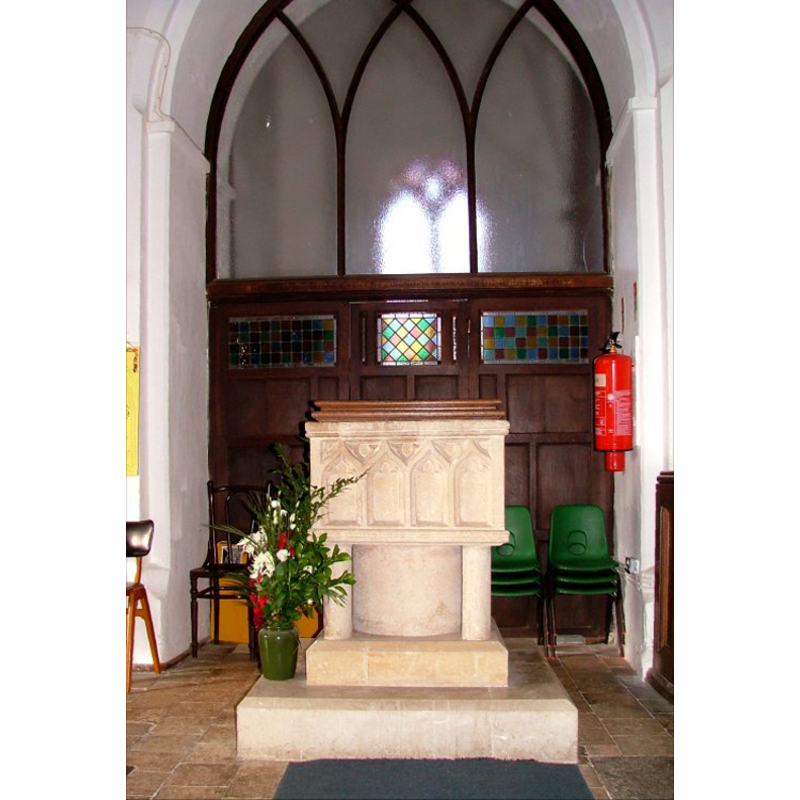
Image copyright © Simon Knott, 2006
Standing permission
Results: 6 records
view of font and cover
Copyright Statement: Image copyright © Simon Knott, 2006
Image Source: digital photograph March 2006 taken by Simon Knott [www.norfolkchurches.co.uk/yelverton/yelverton.htm] [accessed 9 September 2009]
Copyright Instructions: Standing permission
view of font
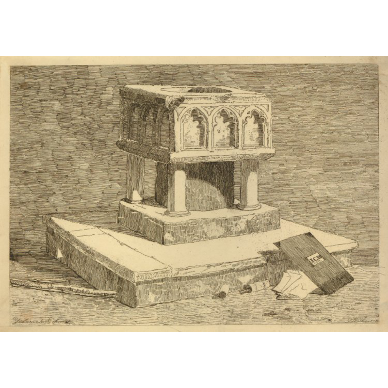
Copyright Statement: Image copyright © Trustees of the British Museum, 2013
Image Source: 1813 print from an etching by J.C. Wright, now in the British Museum collections [ref.: 1902,0514.1113 -- PPA364565]
Copyright Instructions: Reproduced under the British Museum's terms of use
design element - architectural - arcade - blind - Ogee arches - trefoiled arches - 16
Scene Description: re-tooled or re-carved [cf. Font notes]
Copyright Statement: Image copyright © Simon Knott, 2006
Image Source: digital photograph March 2006 taken by Simon Knott [www.norfolkchurches.co.uk/yelverton/yelverton.htm] [accessed 9 September 2009]
Copyright Instructions: Standing permission
design element - motifs - trefoil - 16
Scene Description: in the spandrels of the arcade; re-tooled or re-carved [cf. Font notes]
Copyright Statement: Image copyright © Simon Knott, 2006
Image Source: digital photograph March 2006 taken by Simon Knott [www.norfolkchurches.co.uk/yelverton/yelverton.htm] [accessed 9 September 2009]
Copyright Instructions: Standing permission
view of church exterior - southeast view
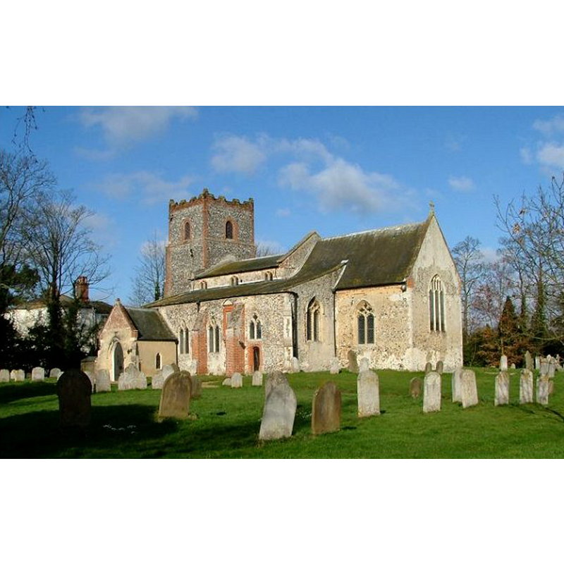
Copyright Statement: Image copyright © Simon Knott, 2006
Image Source: digital photograph March 2006 taken by Simon Knott [www.norfolkchurches.co.uk/yelverton/yelverton.htm] [accessed 24 April 2013]
Copyright Instructions: Standing permission
view of church interior - nave - looking east
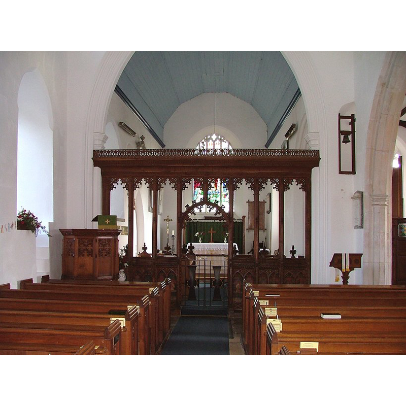
Copyright Statement: Image copyright © Simon Knott, 2006
Image Source: digital photograph March 2006 taken by Simon Knott [www.norfolkchurches.co.uk/yelverton/yelverton.htm] [accessed 24 April 2013]
Copyright Instructions: Standing permission
INFORMATION
Font ID: 15273YEL
Object Type: Baptismal Font1
Font Century and Period/Style: 13th - 14th century [re-tooled?], Early English? / Decorated? [altered]
Church / Chapel Name: Parish Church of St. Mary
Font Location in Church: Inside the church, at the W end of the nave
Church Patron Saint(s): St. Mary the Virgin
Church Address: 19 Church Road, Yelverton, Norfolk NR14 7PB
Site Location: Norfolk, East Anglia, England, United Kingdom
Directions to Site: Located 10 km ESE of Norwich
Ecclesiastic Region: Diocese of Norwich
Historical Region: Hundred of Henstede [aka Henstead]
Additional Comments: altered font / re-tooled? / re-cut? -- disappeared font? (the one from the Domesday-time church here)
Font Notes:
Click to view
Blomefield (1805-1810) writes: "At the Conquest there was a church, and 20 acres of glebe, valued at 20d. the advowson of which, belonged to Framingham manor [...] The church is dedicated to St. Mary the Virgin [...] When Norwich Domesday was made the rector had a house and two granges in the churchyard. [...] The church is 33 feet long, and 22 broad. The south isle and chapel at its east end, are 46 feet long, and 13 broad, and are both leaded; the chancel is 31 feet long, and 16 broad, and is thatched. The steeple was rebuilt in 1674, by Thomas Thetford: it is 50 feet high, and contains three bells." Blomefield (ibid.) names "William Bozoun, priest" as its first recorded rector, in 1314. Illustrated on a 1813 print from an etching by J.C. Wright, now in the British Museum collections [ref.: 1902,0514.1113 -- PPA364565]. The present font is described in Pevsner & Wilson (1999): "Square, with arched panels. C13." Noted and illustrated in Knott (2006): "The square Norman font has traceried panels which may be recut. They are echoed in the screen to the tower." The basin and the columns of the base appear to have been re-cut or re-tooled; the lower base and plinth are modern, as is the square wooden cover. [NB: we have no information on the font from the Domesday-time church here].
Credit and Acknowledgements: We are grateful to Simon Knott, of www.norfolkchurches.co.uk, for his photographs of this font and church
COORDINATES
UTM: 31U 390280 5825550
Latitude & Longitude (Decimal): 52.568931, 1.381108
Latitude & Longitude (DMS): 52° 34′ 8.15″ N, 1° 22′ 51.99″ E
MEDIUM AND MEASUREMENTS
Material: stone
Font Shape: square, mounted
Basin Interior Shape: round
Basin Exterior Shape: square
LID INFORMATION
Date: modern
Material: wood
Apparatus: no
Notes: [cf. FontNotes]
REFERENCES
- Blomefield, Francis, An essay towards a topographical history of Norfolk, 1805-1810, vol. 5: 489-495 / [www.british-history.ac.uk/report.aspx?compid=78214] [accessed 24 April 2013]
- Knott, Simon, The Norfolk Churches Site, Simon Knott, 2004. [standing permission to reproduce images received from Simon (February 2005]. URL: www.norfolkchurches.co.uk.
- Pevsner, Nikolaus, Norfolk 2: North-West and South (2nd ed.), London: Penguin, 1999, p. 809