Thorpe St. Andrew / Thorpe by Norwich / Thorpe-next-Norwich / Thorpe Episcopi / Torp
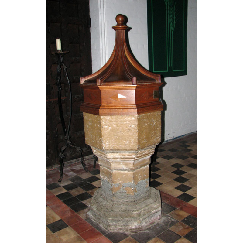
Image copyright © Evelyn Simak, 2010
CC-BY-SA-3.0
Results: 10 records
view of font and cover
Copyright Statement: Image copyright © Evelyn Simak, 2010
Image Source: digital photograph taken 20 September 2010 by Evelyn Simak [www.geograph.org.uk/photo/2074769] [accessed 13 August 2013]
Copyright Instructions: CC-BY-SA-3.0
design element - motifs - moulding - graded
Copyright Statement: Image copyright © Evelyn Simak, 2010
Image Source: digital photograph taken 20 September 2010 by Evelyn Simak [www.geograph.org.uk/photo/2074769] [accessed 13 August 2013]
Copyright Instructions: CC-BY-SA-3.0
view of church exterior - east view
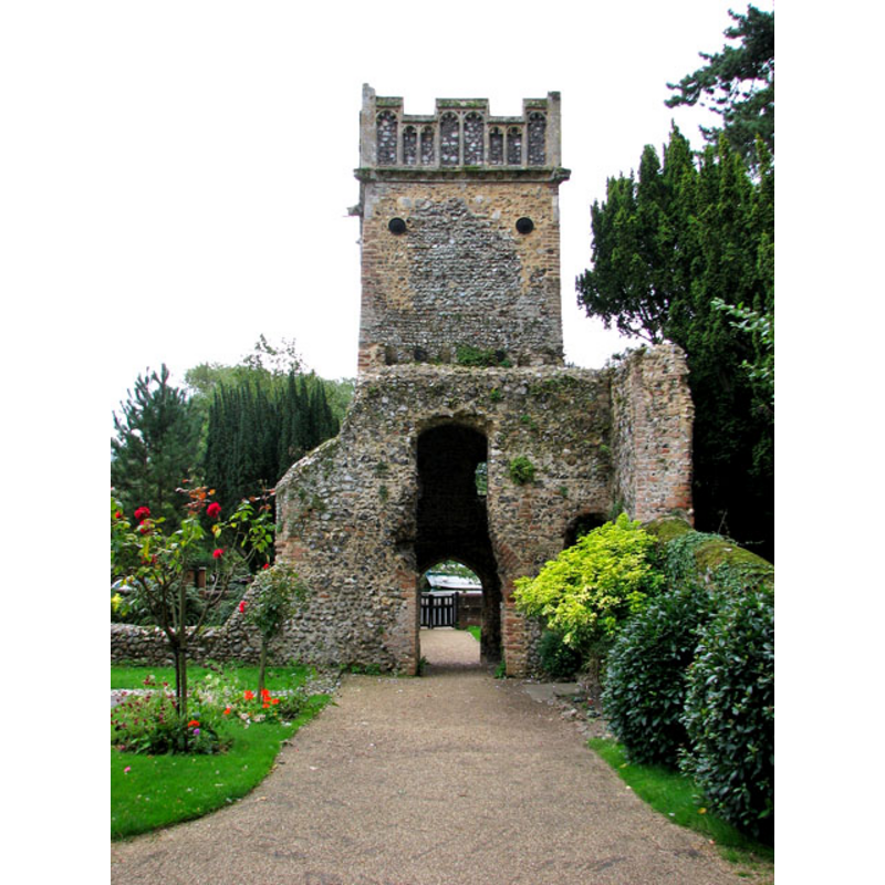
Scene Description: the ruins of Old St. Andrew's church in 2010
Copyright Statement: Image copyright © Evelyn Simak, 2010
Image Source: digital photograph taken 20 September 2010 by Evelyn Simak [www.geograph.org.uk/photo/2074681] [accessed 13 August 2013]
Copyright Instructions: CC-BY-SA-3.0
view of church exterior - northeast view
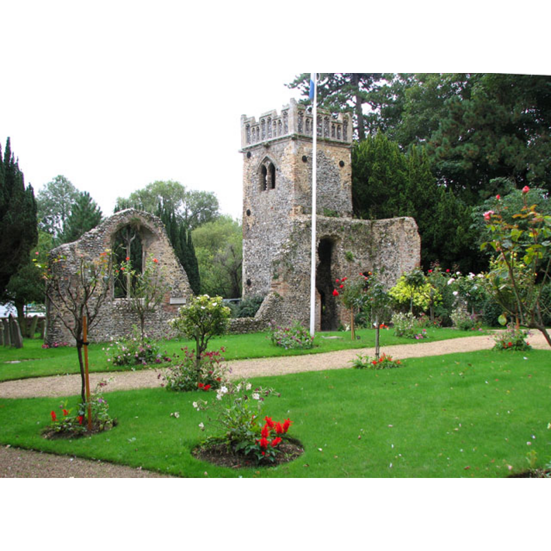
Scene Description: the ruins of Old St. Andrew's church in 2010
Copyright Statement: Image copyright © Evelyn Simak, 2010
Image Source: digital photograph taken 20 September 2010 by Evelyn Simak [www.geograph.org.uk/photo/2074683] [accessed 13 August 2013]
Copyright Instructions: CC-BY-SA-3.0
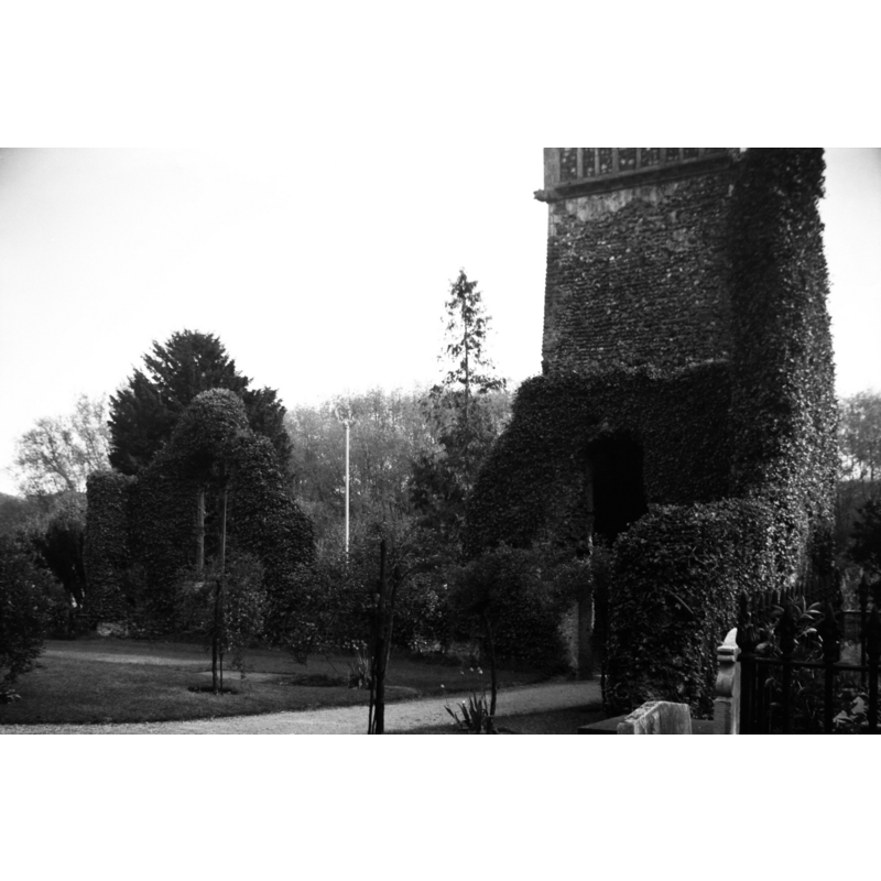
view of church exterior - southeast view
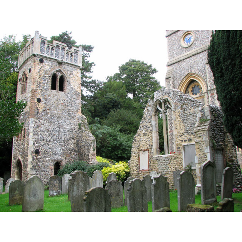
Scene Description: the ruins of Old St. Andrew's church in 2010
Copyright Statement: Image copyright © Evelyn Simak, 2010
Image Source: digital photograph taken 20 September 2010 by Evelyn Simak [www.geograph.org.uk/photo/2074673] [accessed 13 August 2013]
Copyright Instructions: CC-BY-SA-3.0
view of church exterior - northeast view
Scene Description: the ruins of Old St. Andrew's church in 1940
Copyright Statement: Image copyright © George Plunkett, 2013
Image Source: B&W photograph taken 11 May 1940 by George Plunkett [www.georgeplunkett.co.uk/Norfolk/T/Thorpe St Andrew's church ruin north side [3411] 1940-05-11.jpg] [accessed 13 August 2013]
Copyright Instructions: Standing permission by Jonathan Plunkett
view of church exterior - southwest end
![the ruins of Old St. Andrew's church in 1940
EXT SE digital photograph taken 20 September 2010 by Evelyn Simak [www.geograph.org.uk/photo/2074673] [accessed 13 August 2013]
EXT NE digital photograph taken 20 September 2010 by Evelyn Simak [www.geograph.org.uk/photo/2074683] [accessed 13 August 2013]
EXT E digital photograph taken 20 September 2010 by Evelyn Simak [www.geograph.org.uk/photo/2074681] [accessed 13 August 2013]
INT E NEWCHURCH digital photograph taken 20 September 2010 by Evelyn Simak [www.geograph.org.uk/photo/2074718] [accessed 13 August 2013]
INT W NEWCHURCH digital photograph taken 20 September 2010 by Evelyn Simak [www.geograph.org.uk/photo/2074758] [accessed 13 August 2013]
FONT digital photograph taken 20 September 2010 by Evelyn Simak [www.geograph.org.uk/photo/2074769] [accessed 13 August 2013]](/static-50478a99ec6f36a15d6234548c59f63da52304e5/compressed/1130813040_compressed.png)
Scene Description: the ruins of Old St. Andrew's church in 1940
EXT SE digital photograph taken 20 September 2010 by Evelyn Simak [www.geograph.org.uk/photo/2074673] [accessed 13 August 2013]
EXT NE digital photograph taken 20 September 2010 by Evelyn Simak [www.geograph.org.uk/photo/2074683] [accessed 13 August 2013]
EXT E digital photograph taken 20 September 2010 by Evelyn Simak [www.geograph.org.uk/photo/2074681] [accessed 13 August 2013]
INT E NEWCHURCH digital photograph taken 20 September 2010 by Evelyn Simak [www.geograph.org.uk/photo/2074718] [accessed 13 August 2013]
INT W NEWCHURCH digital photograph taken 20 September 2010 by Evelyn Simak [www.geograph.org.uk/photo/2074758] [accessed 13 August 2013]
FONT digital photograph taken 20 September 2010 by Evelyn Simak [www.geograph.org.uk/photo/2074769] [accessed 13 August 2013]
Copyright Statement: Image copyright © George Plunkett, 2013
Image Source: B&W photograph taken 11 May 1940 by George Plunkett [www.georgeplunkett.co.uk/Norfolk/T/Thorpe St Andrew's church ruin from SW [3410] 1940-05-11.jpg] [accessed 13 August 2013]
Copyright Instructions: Standing permission by Jonathan Plunkett
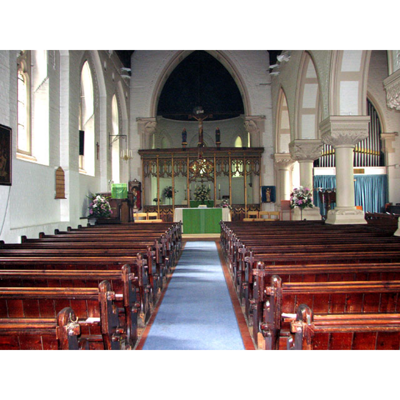
view of church interior - nave - looking west
Scene Description: the old font at the far (west) end
Copyright Statement: Image copyright © Evelyn Simak, 2010
Image Source: digital photograph taken 20 September 2010 by Evelyn Simak [www.geograph.org.uk/photo/2074758] [accessed 13 August 2013]
Copyright Instructions: CC-BY-SA-3.0
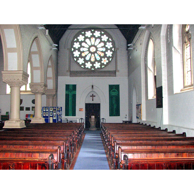
view of church interior - nave - looking east
Scene Description: inside the new church
Copyright Statement: Image copyright © Evelyn Simak, 2010
Image Source: digital photograph taken 20 September 2010 by Evelyn Simak [www.geograph.org.uk/photo/2074718] [accessed 13 August 2013]
Copyright Instructions: CC-BY-SA-3.0
design element - motifs - moulding - graded
Copyright Statement: Image copyright © Evelyn Simak, 2010
Image Source: digital photograph taken 20 September 2010 by Evelyn Simak [www.geograph.org.uk/photo/2074769] [accessed 13 August 2013]
Copyright Instructions: CC-BY-SA-3.0
INFORMATION
Font ID: 15258THO
Object Type: Baptismal Font1
Font Century and Period/Style: 13th century, Early English
Church / Chapel Name: Parish Church of St. Andrew
Font Location in Church: Inside the church, at the W end [cf. FontNotes]
Church Patron Saint(s): St. Andrew
Church Notes: the medieval church was partly destroyed in a fire in the 19th century and abandoned in favour of the new church built thereafter
Church Address: Thunder Lane, Thorpe St Andrew, Norfolk, NR7 0AB
Site Location: Norfolk, East Anglia, England, United Kingdom
Directions to Site: Located on the A1242 (Yarmouth Rd.), 3 km E of Norwich city centre and now an eastern suburb of the city
Ecclesiastic Region: Diocese of Norwich
Historical Region: Hundred of Blofield
Additional Comments: abandoned font / missing font / restored font -- painted font (covered in a thick wash)
Font Notes:
Click to view
Blomefield (1805-1810) writes: "T[horp, by Norwich], Called Torp in the survey [i.e., Domesday]. Stigand Archbishop of Canterbury was lord of it in the reign of the Confessor" [i.e., 1042-1066]; the Domesday entry for "Torp" cited in this author mentions neither church nor cleric in this town. Blomefield (ibid.) adds: "The Church is dedicated to St. Andrew [...] Thomas de Middleton was vicar, and presented [...] about 1200 by the prior" [of the priory of Norwich], which indicates that a vicarage existed here prior to 1200, and must have become a rectory at a later date since in 1303 "John de Nassington" was "rector, collated by the Bishop" [of Norwich]. The old church was abandoned in favout of a new one built in the 19th century. The baptismal font from the old church appears to have been missing at the time [cf. infra] but was found and installed in the new building at some point. White's Directory of 1836 describes the old church before its demise: "a thatched Gothic fabric, with a nave, chancel, porch, and embattled tower. The living is a rectory", but does not mention the font. The old font is noted in Michael Ireland's Thorpe St. Andrew page [www.michaelireland.co.uk/16253.html] [accessed 8 September 2008]: "At the west end there is a 13th century font. It is plain and octagonal and was once in the former church. A new font was provided when the present church was built because the 13th century font was “missing“. However it was found and replaced the Victorian font (now used as a flower bed in the churchyard)."
COORDINATES
UTM: 31U 387542 5831993
Latitude & Longitude (Decimal): 52.626262, 1.338529
Latitude & Longitude (DMS): 52° 37′ 34.54″ N, 1° 20′ 18.7″ E
MEDIUM AND MEASUREMENTS
Material: stone, limestone?
Font Shape: octagonal, mounted
Basin Interior Shape: round
Basin Exterior Shape: octagonal
LID INFORMATION
Date: modern
Material: wood, oak?
Apparatus: no
Notes: octagonal box-like platform with closed ribbed upper part; ball finial; modern; bears donor plate
REFERENCES
- Blomefield, Francis, An essay towards a topographical history of Norfolk, 1805-1810, vol. 7: 258-264 / [www.british-history.ac.uk/report.aspx?compid=78351] [accessed 13 August 2013]
- White, William, History, gazetteer, and directory of Norfolk and the city and County of the city of Norwich [...], Sheffield: Printed for the Author [...], 1836, p, 342-343
- White, William, History, gazetteer, and directory of Norfolk and the city and County of the city of Norwich [...], Sheffield: Robert Leader, 1845, [transcribed in www.origins.org.uk/genuki/NFK/places/t/thorpe_st_andrew/white1845.shtml [accessed 13 August 2013]]