West Raynham / Raineham / Rainham St. Margaret / Reineham / Reinham / Remeham [Domesday]/ Reynham St. Margaret
![Main image for West Raynham / Raineham / Rainham St. Margaret / Reineham / Reinham / Remeham [Domesday]/ Reynham St. Margaret](/static-50478a99ec6f36a15d6234548c59f63da52304e5/compressed/1120211038_compressed.png)
Image copyright © Janice Tostevin, 2012
Standing permission
Results: 4 records
view of font
Scene Description: the later font remains
Copyright Statement: Image copyright © Janice Tostevin, 2012
Image Source: digital photograph taken 13 July 2011 by Janice Tostevin for BSI
Copyright Instructions: Standing permission
view of font in context
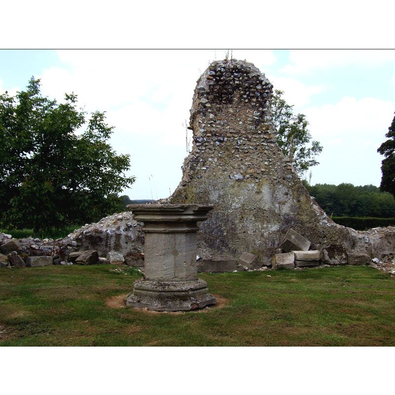
Scene Description: the bulge behind the font may be what survives of the north wall of the church
Copyright Statement: Image copyright © Simon Knott, 2007
Image Source: digital photograph taken 2 September 2007 by Simon Knott [http://www.norfolkchurches.co.uk/westraynham/westraynham.htm] [accessed 4 September 2009]
Copyright Instructions: Standing permission
view of church exterior - south view
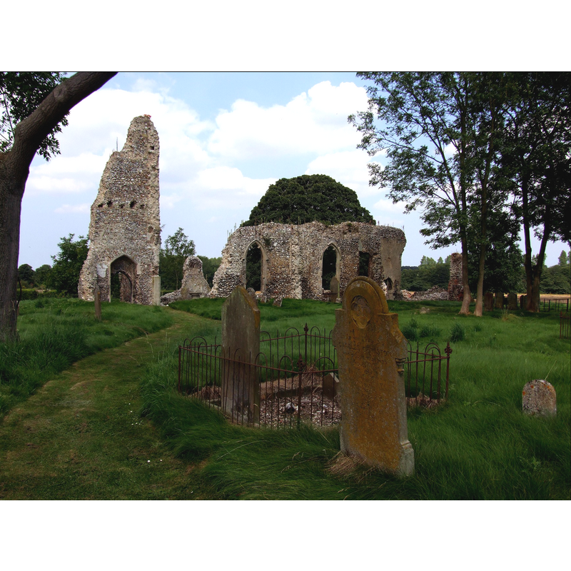
Scene Description: the ruins of the church seen from the churchyard; at the left (west) the remains of the tower
Copyright Statement: Image copyright © Simon Knott, 2007
Image Source: digital photograph taken 2 September 2007 by Simon Knott [http://www.norfolkchurches.co.uk/westraynham/westraynham.htm] [accessed 4 September 2009]
Copyright Instructions: Standing permission
view of church interior - nave
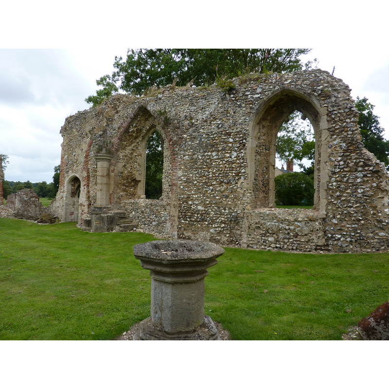
Scene Description: the later font remains in the context of what appears to be the western side of the nave; the remaing wall with the two large windows would be the south wall
Copyright Statement: Image copyright © Janice Tostevin, 2012
Image Source: digital photograph taken 13 July 2011 by Janice Tostevin for BSI
Copyright Instructions: Standing permission
INFORMATION
Font ID: 15244RAY
Object Type: Baptismal Font1?
Font Century and Period/Style: 11th century, Norman
Church / Chapel Name: Parish Church of St. Margaret [in ruins]
Font Location in Church: [cf. FontNotes]
Church Patron Saint(s): St. Margaret of Antioch [aka Margaret the Virgin, Marina]
Church Address: The Street, West Raynham, Norfolk, NR21 7
Site Location: Norfolk, East Anglia, England, United Kingdom
Directions to Site: Located 7 km SW of Fakenham
Ecclesiastic Region: Diocese of Norwich
Historical Region: Hundreds of Gallow and Brothercross
Additional Comments: disappeared font? (the one from the medieval church here)
Font Notes:
Click to view
Blomefield (1805-1810) writes about "RAINEHAM, Or Reineham, as it is wrote in the book of Domesday", in which, "part of the town now called East Rainham, and made up that parish, or lordship, as I take it, called now Rainham-Magna [...] South Rainham was then a beruite, that is, a less manor, and depending on this"; a third part was West Reinham. Blomefield (ibid.) reports that "In 1316, Thomas, son of Thomas de Hauvill, held by his father's enfeoffment, the manors of Dunton and Reynham, with the advowson of the church of Reynham St. Margaret [...] and in the said year, he gave to the priory of Miremound the patronage of the aforesaid church, with one acre of land." Blomefield (ibid.) adds: "This church has a nave, and a north isle, covered with lead, and a chancel with tiles", and names 'Richard de Walton' as first recorded rector, in 1322. White's Gazetteer of Norfolk for 1854 (p. 702) reports that the Church of St. Margaret "has long been dilapidated". The church is not mentioned in James (1930). The Church of England entry for this church [www.achurchnearyou.com/west-raynham-st-margaret/] [accessed 11 February 2012] notes: "This church was first built in the 11th century and extended in the 14th century. It fell into ruin from the 1720's when the roof lead was removed to help pay for the restoration of S. Mary's, East Raynham. The ruin has now been consolidated and the church is now back in occasional use." Among the ruins are what looks like the remains of a baptismal font: a plain octagonal stem on a moulded splaying lower base of the same shape; atop, the underbowl chamfer decorated with graded mouldings, and the bottom of an octagonal basin. It does not correspond to a font of the 11th or the 14th century. Knott (2007) suggests a font of the 18th century. [NB: a note accompanying a 27 June 2010 photograph of the ruins by Evelyn Simak [www.geograph.org.uk/photo/1938752] [accessed 11 February 2012], however, reads: "a 'font' was reconstructed by using two capitals and a column section." -- we have no information on the earlier font(s) of this church].
Credit and Acknowledgements: We are grateful to Simon Knotts, of www.norfolkchurches.co.uk, and to Janice Tostevin for their photographs of this church ruins and later font remains
COORDINATES
UTM: 31U 349942 5851603
REFERENCES
- Blomefield, Francis, An essay towards a topographical history of Norfolk, 1805-1810, vol. 7: 121-151 / [www.british-history.ac.uk/report.aspx?compid=78317] [accessed 30 July 2013]
- Knott, Simon, The Norfolk Churches Site, Simon Knott, 2004. [standing permission to reproduce images received from Simon (February 2005]. URL: www.norfolkchurches.co.uk.