West Bilney / Benelai
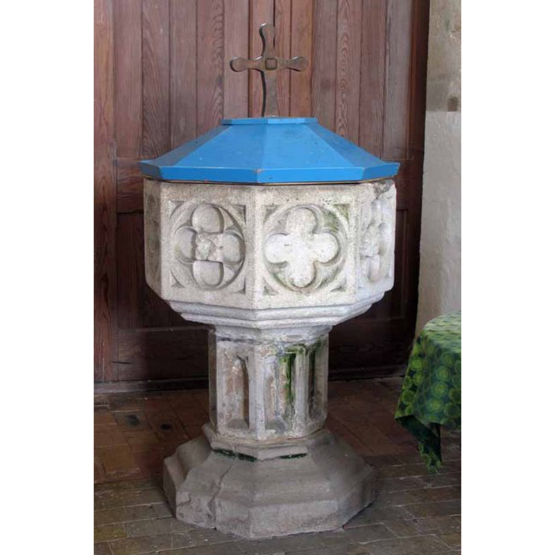
Image copyright © John Salmon, 2008
CC-BY-SA-3.0
Results: 11 records
view of font and cover
Scene Description: the cover said to have been designed by Sir John Ninian Comper (1864-1960) [cf. FontNotes]
Copyright Statement: Image copyright © John Salmon, 2008
Image Source: digital photograph taken 13 February 2008 by John Salmon [www.geograph.org.uk/photo/697363] [accessed 6 November 2013]
Copyright Instructions: CC-BY-SA-3.0
view of font
Copyright Statement: Image copyright © Evelyn Simak, 2010
Image Source: digital photograph taken 7 March 2010 by Evelyn Simak [www.geograph.org.uk/photo/1743677] [accessed 6 November 2013]
Copyright Instructions: CC-BY-SA-3.0
design element - motifs - quatrefoil - in a circle - in a square - 4
Scene Description: there is no floral motif inside the quatrefoil
Copyright Statement: Image copyright © Evelyn Simak, 2010
Image Source: digital photograph taken 7 March 2010 by Evelyn Simak [www.geograph.org.uk/photo/1743677] [accessed 6 November 2013]
Copyright Instructions: CC-BY-SA-3.0
design element - motifs - floral - in a quatrefoil - in a circle - in a square - 4
Scene Description: the motifs vary: rosette, square flower, etc.
Copyright Statement: Image copyright © Evelyn Simak, 2010
Image Source: digital photograph taken 7 March 2010 by Evelyn Simak [www.geograph.org.uk/photo/1743677] [accessed 6 November 2013]
Copyright Instructions: CC-BY-SA-3.0
design element - motifs - moulding - graded
Copyright Statement: Image copyright © Evelyn Simak, 2010
Image Source: digital photograph taken 7 March 2010 by Evelyn Simak [www.geograph.org.uk/photo/1743677] [accessed 6 November 2013]
Copyright Instructions: CC-BY-SA-3.0
view of church exterior - northwest view
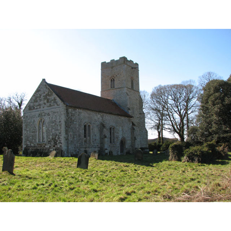
Copyright Statement: Image copyright © Evelyn Simak, 2010
Image Source: digital photograph taken 7 March 2010 by Evelyn Simak [www.geograph.org.uk/photo/1743630] [accessed 6 November 2013]
Copyright Instructions: CC-BY-SA-3.0
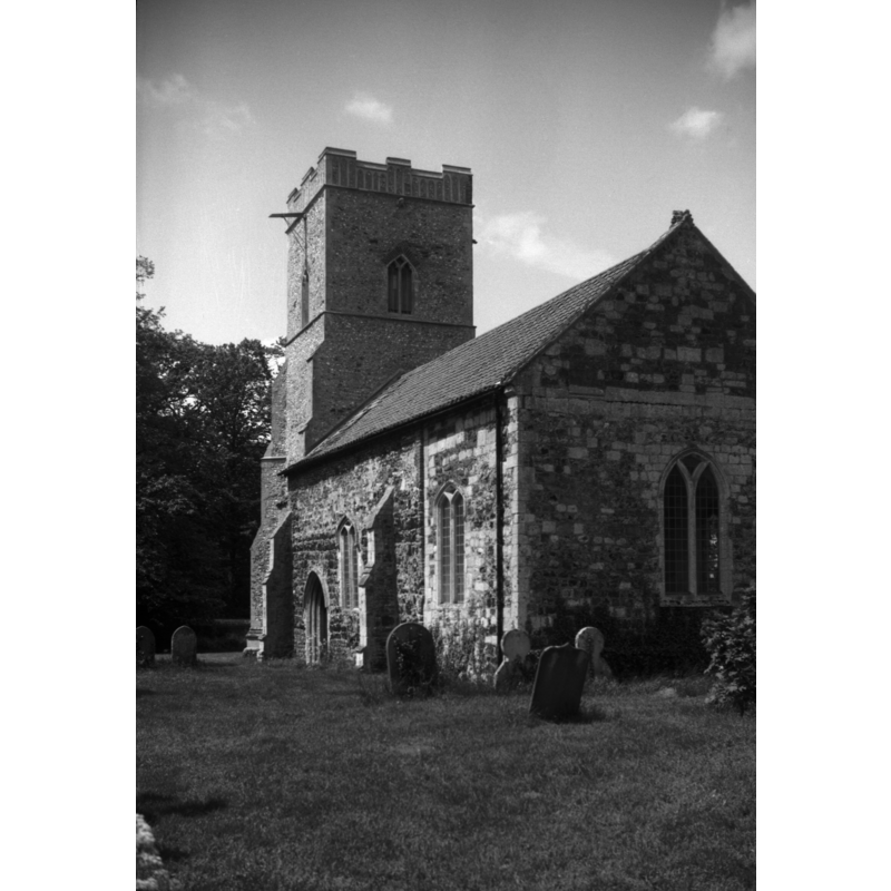
view of church exterior - southeast view
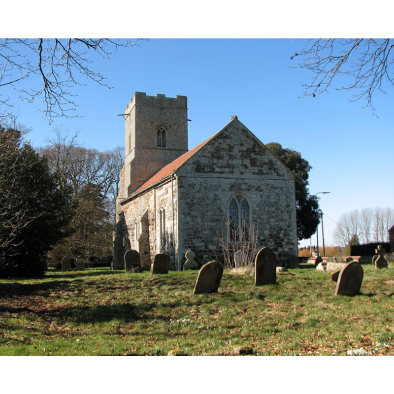
Copyright Statement: Image copyright © Evelyn Simak, 2010
Image Source: digital photograph taken 7 March 2010 by Evelyn Simak [www.geograph.org.uk/photo/1743643] [accessed 6 November 2013]
Copyright Instructions: CC-BY-SA-3.0
view of church exterior - southeast view
Copyright Statement: Image copyright © George Plunkett, 2013
Image Source: B&W photograph taken 31 May 1996 by George Plunkett [www.georgeplunkett.co.uk/Norfolk/W/W Bilney St Cecilia's church from SE [7325] 1996-05-31.jpg] [accessed 6 November 2013]
Copyright Instructions: Standing permission by Jonathan Plunkett
view of church interior - nave - looking west
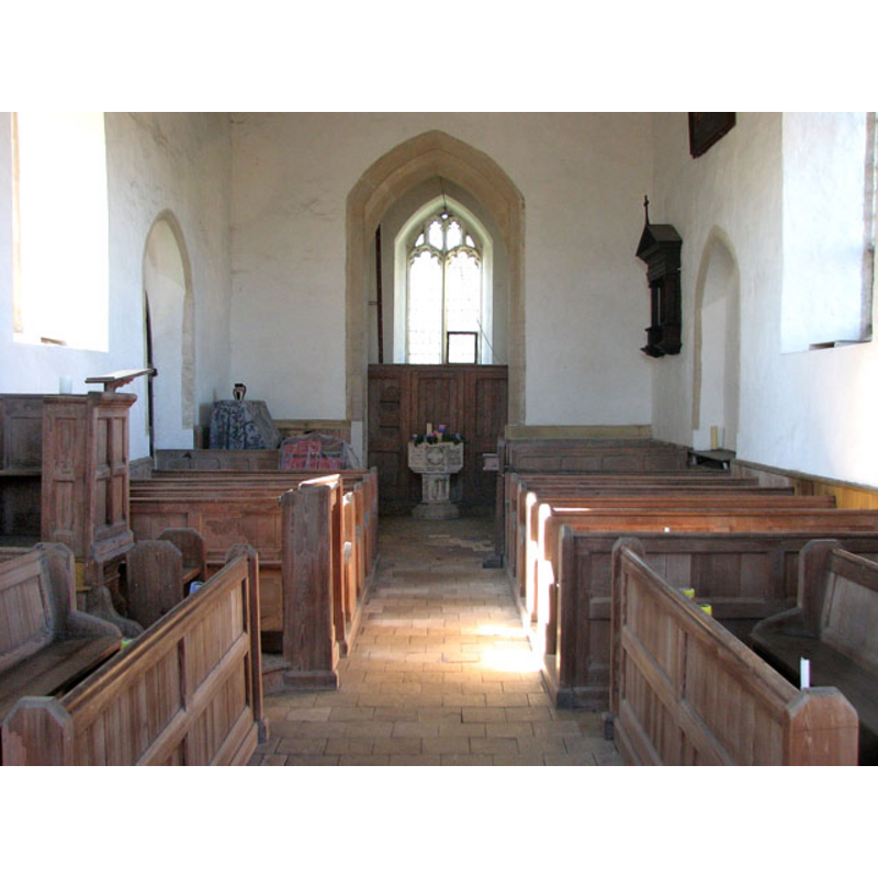
Scene Description: the font at the west end
Copyright Statement: Image copyright © Evelyn Simak, 2010
Image Source: digital photograph taken 7 March 2010 by Evelyn Simak [www.geograph.org.uk/photo/1743671] [accessed 6 November 2013]
Copyright Instructions: CC-BY-SA-3.0
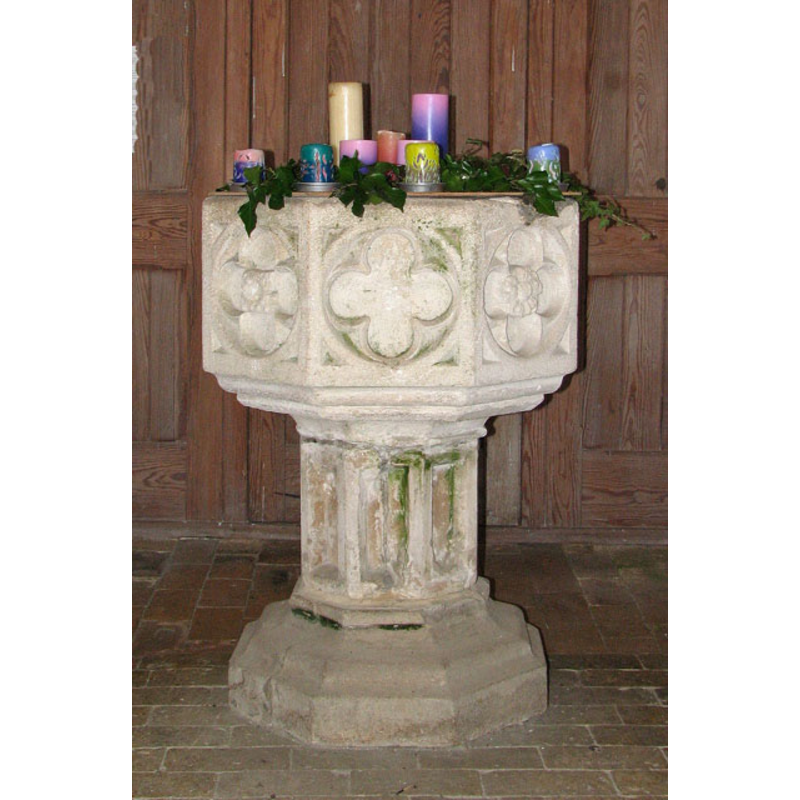
view of church interior - nave - looking east
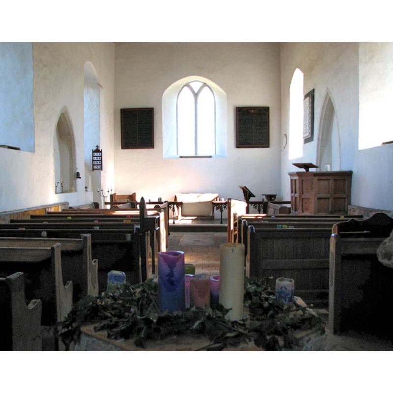
Scene Description: in the foregound, centre, an arrangement of candles nested on top of the font
Copyright Statement: Image copyright © Evelyn Simak, 2010
Image Source: digital photograph taken 7 March 2010 by Evelyn Simak [www.geograph.org.uk/photo/1743658] [accessed 6 November 2013]
Copyright Instructions: CC-BY-SA-3.0
design element - architectural - niche or window - 8
Copyright Statement: Image copyright © Evelyn Simak, 2010
Image Source: digital photograph taken 7 March 2010 by Evelyn Simak [www.geograph.org.uk/photo/1743677] [accessed 6 November 2013]
Copyright Instructions: CC-BY-SA-3.0
INFORMATION
Font ID: 15238BIL
Object Type: Baptismal Font1
Font Century and Period/Style: 14th - 15th century, Early Perpendicular
Church / Chapel Name: Parish Church of St. Cecilia [redundant]
Font Location in Church: Inside the church, at the W end of the nave
Church Patron Saint(s): St. Cecilia [aka Caecelia, Cecelia]
Church Address: East Winch, West Bilney Norfolk PE32 1HS
Site Location: Norfolk, East Anglia, England, United Kingdom
Directions to Site: Located off (S) the A47, 12 km ESE of King's Lynn
Ecclesiastic Region: Diocese of Norwich
Historical Region: Hundred and half of Freebridge
Additional Comments: [not yet in Knott - checked 4 Sept 2009]
Font Notes:
Click to view
The entry for "Benelai" in the Domesday survey [http://domesdaymap.co.uk/place/TF7115/west-bilney/] [accessed 6 November 2013] mentions neither church nor cleric in it. Blomefield (1805-1810) writes: "The Church is dedicated to St. Cecilia [...] Hugh occurs rector in the reign of Henry III." [i.e., 1216-1272]; his list of rectors stops when West Bilney was set as a vicarage instead in 1341. The present font is described in White's Directory of 1883: "the font is of the Perpendicular period and ornamented with quatrefoils". In Pevsner & Wilson (1999): "Simple, octagonal, Perp[endicular], with encircled quatrefoils." The church guide in the East & West Bilney Community Project [www.eastwinchandwestbilney.co.uk/history/the-church] [accessed 6 November 2013] notes: "The octagonal font bears the Howard arms and those of Sir John Howard II wife, Alice Bosco. It would have been given by them or by their son Robert, who died in 1388 before his father, and is older than the apparent date of the nave architecture. The font cover was designed by the great church architect Sir Ninian Comper, and erected in memory of Rev. Alvis, who had longed to see it replaced. A complete description of it hangs by the tower arch. It is supposed to be a faithful copy of the medieval cover, illustrated by Weever, but in fact both he and Lilly depicted it as shorter with straight sides. What the original colours were no one knows, and he combination of gilding, blue and white is typical of Comper’s work." This same source states that the font was a gift of the Howard family. All the panels of the basin contain inscribed quatrefoils, they alternate between those with floral motifs in them and those without; braded underbowl moulding; deeply-carved niches in the pedestal base; the moulded octagonal lower base appears modern.
COORDINATES
UTM: 31U 333814 5842612
Latitude & Longitude (Decimal): 52.707859, 0.54006
Latitude & Longitude (DMS): 52° 42′ 28.29″ N, 0° 32′ 24.22″ E
MEDIUM AND MEASUREMENTS
Material: stone
Font Shape: octagonal, mounted
Basin Interior Shape: round
Basin Exterior Shape: octagonal
LID INFORMATION
Date: 19th - 20th century?
Material: wood
Apparatus: no
Notes: [cf. FontNotes]
REFERENCES
- Blomefield, Francis, An essay towards a topographical history of Norfolk, 1805-1810, vol. 8: 352-356 / [www.british-history.ac.uk/report.aspx?compid=78479] [accessed 6 November 2013]
- Pevsner, Nikolaus, Norfolk 2: North-West and South (2nd ed.), London: Penguin, 1999, p. 762
- White, William, History, Gazetteer, and Directory of Norfolk, [s.l.]: [printed for the author], 1883, [transcribed in www.origins.org.uk/genuki/NFK/places/b/bilney_west/white1883.shtml [accessed 4 September 2009]]