Upwell / Utnuella / Utuuella / Well / Wella / Welle / Welles
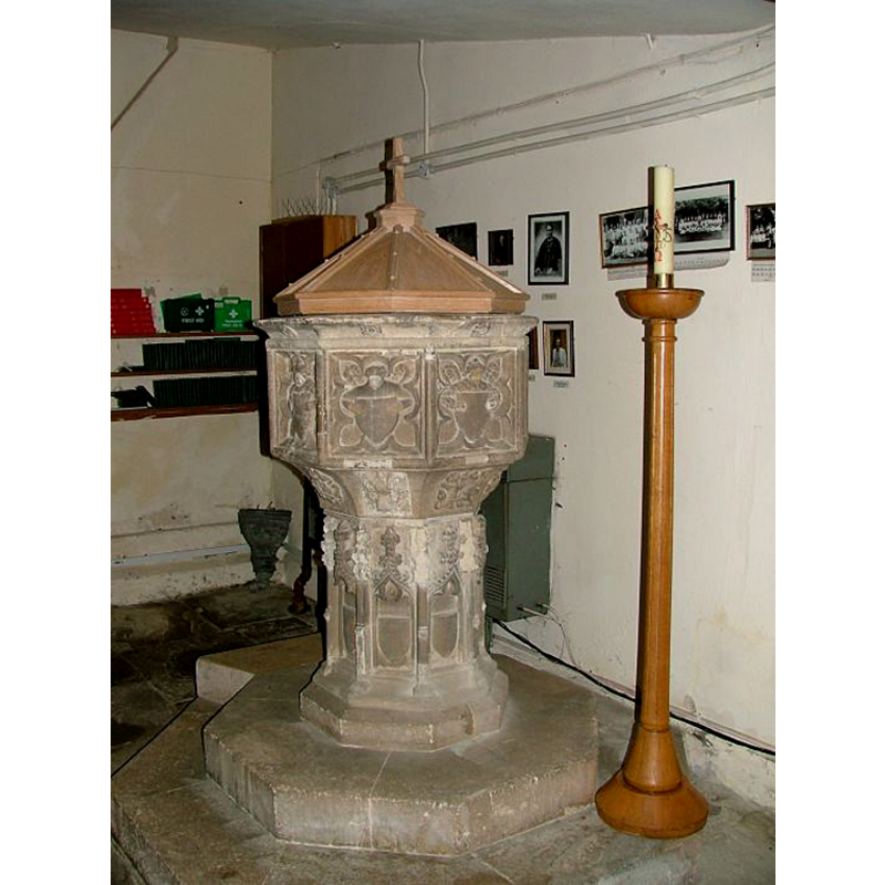
Image copyright © Simon Knott, 2005
Standing permission
Results: 10 records
view of font and cover
Copyright Statement: Image copyright © Simon Knott, 2005
Image Source: digital photograph taken 6 August 2005 by Simon Knott [http://www.norfolkchurches.co.uk/upwell/upwell.htm] [accessed 3 September 2009]
Copyright Instructions: Standing permission
design element - motifs - floral - 8
Copyright Statement: Image copyright © Simon Knott, 2005
Image Source: digital photograph taken 6 August 2005 by Simon Knott [http://www.norfolkchurches.co.uk/upwell/upwell.htm] [accessed 3 September 2009]
Copyright Instructions: Standing permission
angel - demi-figure - holding shield - blank - 8
Copyright Statement: Image copyright © Simon Knott, 2005
Image Source: digital photograph taken 6 August 2005 by Simon Knott [http://www.norfolkchurches.co.uk/upwell/upwell.htm] [accessed 3 September 2009]
Copyright Instructions: Standing permission
design element - motifs - floral - 8
Copyright Statement: Image copyright © Simon Knott, 2005
Image Source: digital photograph taken 6 August 2005 by Simon Knott [http://www.norfolkchurches.co.uk/upwell/upwell.htm] [accessed 3 September 2009]
Copyright Instructions: Standing permission
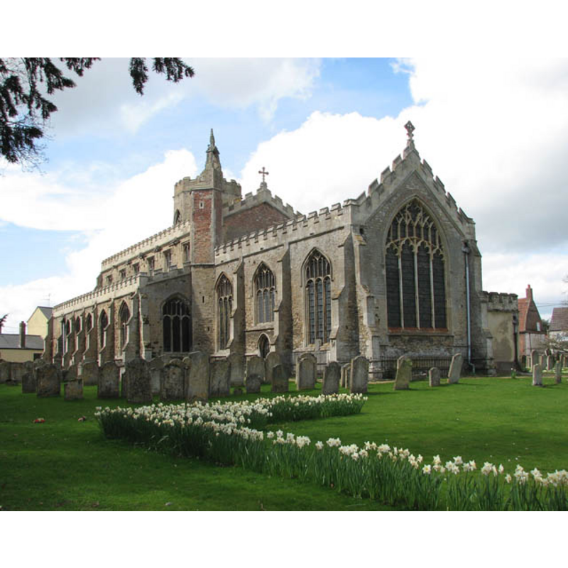
view of church exterior - northeast view
Copyright Statement: Image copyright © Evelyn Simak, 2009
Image Source: digital photograph taken 7 April 2009 by Evelyn Simak [www.geograph.org.uk/photo/1241020] [accessed 29 August 2013]
Copyright Instructions: CC-BY-SA-3.0
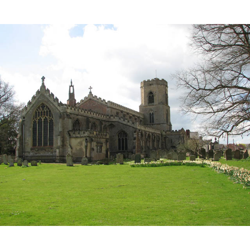
view of church exterior - southeast view
Copyright Statement: Image copyright © Evelyn Simak, 2009
Image Source: digital photograph taken 7 April 2009 by Evelyn Simak [www.geograph.org.uk/photo/1241025] [accessed 29 August 2013]
Copyright Instructions: CC-BY-SA-3.0
view of church exterior - northeast view
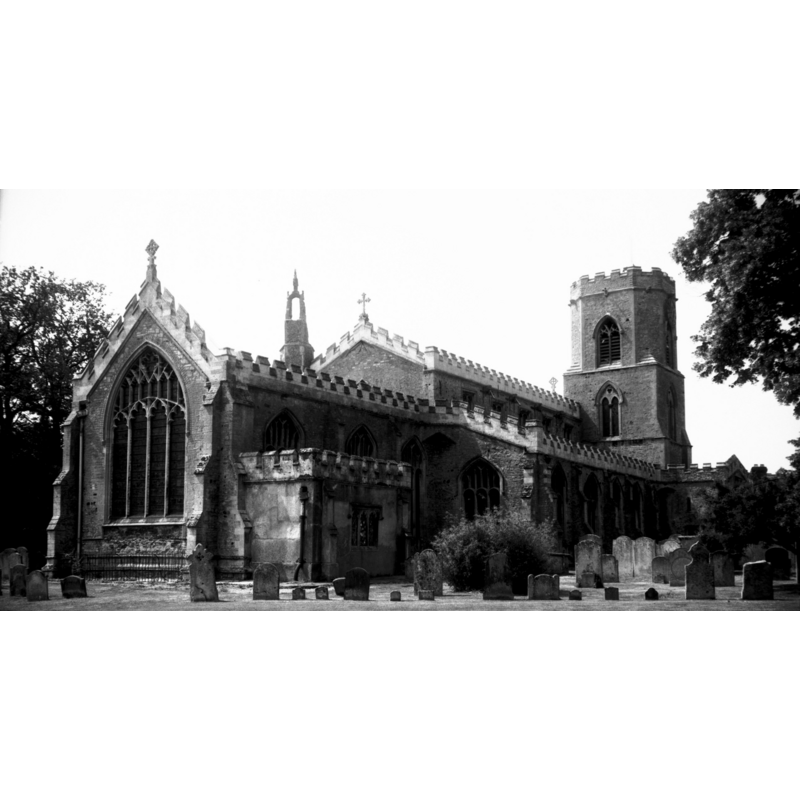
Copyright Statement: Image copyright © George Plunkett, 2013
Image Source: B&W photograph taken 20 July 1996 by George Plunkett [www.georgeplunkett.co.uk/Norfolk/U/Upwell St Peter's church from NE [7362] 1996-07-20.jpg] [accessed 30 August 2013
Copyright Instructions: Standing permission by Jonathan Plunkett
view of church exterior - southeast view
![EXT SE B&W photograph taken 20 July 1996 by George Plunkett [www.georgeplunkett.co.uk/Norfolk/U/Upwell St Peter's church from SE [7361] 1996-07-20.jpg] [accessed 29 August 2013]
EXT NE B&W photograph taken 20 July 1996 by George Plunkett [www.georgeplunkett.co.uk/Norfolk/U/Upwell St Peter's church from NE [7362] 1996-07-20.jpg
EXT SE digital photograph taken 7 April 2009 by Evelyn Simak [www.geograph.org.uk/photo/1241025] [accessed 29 August 2013]
EXT NE digital photograph taken 7 April 2009 by Evelyn Simak [www.geograph.org.uk/photo/1241020] [accessed 29 August 2013]
INT E digital photograph taken 22 April 2009 by Evelyn Simak [www.geograph.org.uk/photo/1822484] [accessed 29 August 2013]](/static-50478a99ec6f36a15d6234548c59f63da52304e5/compressed/1130830011_compressed.png)
Scene Description: EXT SE B&W photograph taken 20 July 1996 by George Plunkett [www.georgeplunkett.co.uk/Norfolk/U/Upwell St Peter's church from SE [7361] 1996-07-20.jpg] [accessed 29 August 2013]
EXT NE B&W photograph taken 20 July 1996 by George Plunkett [www.georgeplunkett.co.uk/Norfolk/U/Upwell St Peter's church from NE [7362] 1996-07-20.jpg
EXT SE digital photograph taken 7 April 2009 by Evelyn Simak [www.geograph.org.uk/photo/1241025] [accessed 29 August 2013]
EXT NE digital photograph taken 7 April 2009 by Evelyn Simak [www.geograph.org.uk/photo/1241020] [accessed 29 August 2013]
INT E digital photograph taken 22 April 2009 by Evelyn Simak [www.geograph.org.uk/photo/1822484] [accessed 29 August 2013]
Copyright Statement: Image copyright © George Plunkett, 2013
Image Source: B&W photograph taken 20 July 1996 by George Plunkett [www.georgeplunkett.co.uk/Norfolk/U/Upwell St Peter's church from SE [7361] 1996-07-20.jpg] [accessed 29 August 2013]
Copyright Instructions: Standing permission by JonathaStanding permission by Jonathan Plunkettn Plunkett
view of church interior - nave - looking east
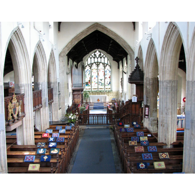
Copyright Statement: Image copyright © Evelyn Simak, 2009
Image Source: digital photograph taken 22 April 2009 by Evelyn Simak [www.geograph.org.uk/photo/1822484] [accessed 29 August 2013]
Copyright Instructions: CC-BY-SA-3.0
design element - architectural - pinnacle - crocketed pinnacle - 8
Copyright Statement: Image copyright © Simon Knott, 2005
Image Source: digital photograph taken 6 August 2005 by Simon Knott [http://www.norfolkchurches.co.uk/upwell/upwell.htm] [accessed 3 September 2009]
Copyright Instructions: Standing permission
INFORMATION
Font ID: 15231UPW
Object Type: Baptismal Font1
Font Century and Period/Style: 15th century / 18th century, Perpendicular? / Victorian?
Workshop/Group/Artisan: heraldic font
Church / Chapel Name: Parish Church of St. Peter
Font Location in Church: Inside the church, at the W end
Church Patron Saint(s): St. Peter
Church Address: Small Lode, Upwell, Norfolk, PE14 9AA
Site Location: Norfolk, East Anglia, England, United Kingdom
Directions to Site: Located on the A1101, 10 km SE of Wisbech [NB: most of the civil parish is located in Cambs., but the church is in Norfolk]
Ecclesiastic Region: Diocese of Ely
Historical Region: Hundred of Clackclose
Additional Comments: disappeared fonts? (the ones from the two Domesday-time churches here)
Font Notes:
Click to view
There are five entries for Upwell [variant spelling] in the Domesday survey [http://opendomesday.org/place/TF5002/upwell/] [accessed 26 April 2016], one of which mentions two churches and church lands in it [NB: could one of the two be Outwell's?]. Blomefield (1805-1810) writes: "U[pwell and] O[utwell]. The greatest part of these towns with their lands, lie in Cambridgeshire, or the isle of Ely, but as the churches of both stand in Norfolk, I shall offer some particulars relating thereto. [...] The Church of Upwell is dedicated to St. Peter, and is a large regular pile, consisting of a nave, a north and south isle, with a chancel, all of stone, embattled with brick, and covered with lead; the length of the nave is about 71 feet, and the breadth, including the isles, about 51. [...] The roof of this nave is ornamented with carved work, and angels, with their wings expanded bearing insignia relating to the crucifixion, bear up the principals; the whole is supported by neat pillars forming six handsome arches on each side, with as many windows over them. At the east end of this nave, on the south side, is a stone turret and staircase which led to the rood-loft; and on the north side is a table of the benefactors. [...] The north isle has a neat oaken roof, with angels, &c. as the nave, and on the braces, are many swans carved. At the east end of this isle has been a chapel and altar [...] At the west end of this isle stands a tower, the bottom part is foursquare, the upper octangular, of boulder, &c. embattled with brick; on this is a shaft or spire of wood covered with lead; in this tower hang 6 large bells, and here is a town clock; it has a porch of stone, covered with lead, and a room over it; on the old door are also several swans carved, as a rebus, likely, to some benefactor of that name, or as a compliment paid to King Henry IV. who had a swan for his badge or cognisance." Blomefield (ibid.) names "Robert de Gloucester for life" as first recorded rector, to whom "King John, in his 15th year granted this church" [i.e., in 1214], and adds: "In this parish was also a chapel, dedicated to St. Botulf." The present font here is described in Pevsner & Wilson (1999): "Octagonal, Perp[endicular], with demi-figures of angels holding shields." The Victoria County History (Cambridge..., vol. 4, 2002) notes: "The Norwich Valuation of 1254 assessed the churches of Outwell and Upwell at £13 6s. 8d. and £6 13s. 4d. respectively. [...] The earliest portions of the present fabric are the west wall of the nave and the two lower stages of the tower, which are of the middle of the 13th century [...] The 15th-century font has an octagonal bowl with demi-angels holding blank shields on the sides, and the shaft has crocketed canopies with flanking pinnacles and plain shields beneath." Noted and illustrated in Knott (2005). The upper rim has pronounced lip, each side decorated with a rosette; a demi-figure of an angel holding a shield on each side of the basin; the underbowl chamfer is slightly concave and decorated with a large floral motif on each side; the octagonal stem has a niche on each side with a crocketed pinnacle; plain octagonal lower base; two-step plinth. This is a font that varies significantly from the regional patterns of the period. Octagonal pyramidal wooden -oak- cover with Latin cross finial; modern.
Credit and Acknowledgements: We are grateful to Jonathan Plunkett, for the fotograph of this church taken by his father, George Plunkett, in July 1996, and to Simon Knott, of Norfolk Churches [www.norfolkchurches.co.uk] for his photograph of this modern font
COORDINATES
UTM: 31U 311918 5831613
Latitude & Longitude (Decimal): 52.601934, 0.222609
Latitude & Longitude (DMS): 52° 36′ 6.96″ N, 0° 13′ 21.39″ E
MEDIUM AND MEASUREMENTS
Material: stone
Font Shape: octagonal, mounted
Basin Interior Shape: round
Basin Exterior Shape: octagonal
LID INFORMATION
Date: modern
Material: wood, oak
Apparatus: no
Notes: [cf. FontNotes]
REFERENCES
- Victoria County History [online], University of London, 1993-. URL: https://www.british-history.ac.uk.
- Blomefield, Francis, An essay towards a topographical history of Norfolk, 1805-1810, vol. 7: 454-478 / [www.british-history.ac.uk/report.aspx?compid=78382] [accessed 29 August 2013]
- Knott, Simon, The Norfolk Churches Site, Simon Knott, 2004. [standing permission to reproduce images received from Simon (February 2005]. URL: www.norfolkchurches.co.uk.
- Pevsner, Nikolaus, Norfolk 2: North-West and South (2nd ed.), London: Penguin, 1999, p. 740