Testerton / Estretuna
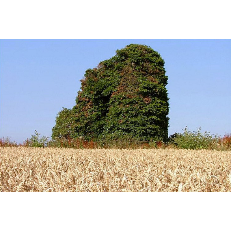
Image copyright © Simon Knott, 2006
Standing permission
Results: 1 records
view of church exterior
Scene Description: the ruins of St. Remigius' church in 2006
Copyright Statement: Image copyright © Simon Knott, 2006
Image Source: digital photograph taken August 2006 by Simon Knott [www.norfolkchurches.co.uk/testerton/testerton.htm] [accessed 6 August 2013]
Copyright Instructions: Standing permission
INFORMATION
Font ID: 15201TES
Object Type: Baptismal Font1?
Font Century and Period/Style: Medieval
Church / Chapel Name: Parish Church of St. Remigius [in ruins]
Font Location in Church: [cf. FontNotes]
Church Patron Saint(s): St. Remigius of Reims [aka Remi, Rémi, Remy]
Site Location: Norfolk, East Anglia, England, United Kingdom
Directions to Site: Located 2 km ENE of Colkirk, between Fakenham and Great Ryburgh
Ecclesiastic Region: Diocese of Norwich
Historical Region: Hundreds of Gallow and Brothercross
Additional Comments: disappeared font? (the one from the medieval church here)
Font Notes:
Click to view
Blomefield (1805-1810) writes; "It is called, in Domesday Book, Estretuna [...] The Church of Testerton, is dedicated to St. Remigius, and is a rectory", and names "Richard de Elyngham" first recorded rector, in 1324, but notes that the advowson of this church change hands "In the 13th of Edward I [i.e., 1285] [...] by fine". The last rector of this church listed in Blomefield (ibid.) took over in 1749. White's Directory of 1845 notes that the church of Testerton St. Remigius "has been long in ruins", and Kelly's 1883 Directory reports: "The church, which fell into ruins many years since, has almost disappeared, a portion of the tower alone remains". Knott (2006) writes: "If you don't know where to look, St Remigius disguises itself rather effectively as a large tree, and it is only when you are immediately to the west of it that you can see the tower window [...] At some point, probably in the 18th century, the ruined tower has been surrounded by an iron fence, and forgotten." [NB: we have no information on the font of the medieval church here].
Credit and Acknowledgements: We are grateful to Simon Knott, of Norfolk Churches [www.norfolkchurches.co.uk], for his photograph of the remains of this church
COORDINATES
UTM: 31U 356642 5852507
Latitude & Longitude (Decimal): 52.803281, 0.873369
Latitude & Longitude (DMS): 52° 48′ 11.81″ N, 0° 52′ 24.13″ E
REFERENCES
- Blomefield, Francis, An essay towards a topographical history of Norfolk, 1805-1810, vol. 7: 197-200 / [www.british-history.ac.uk/report.aspx?compid=78330] [accessed 6 August 2013]
- Kelly, Kelly's Directory for Cambridge, Norfolk & Suffolk, London: Kelly's Directories Ltd., 1883, p. 238
- Knott, Simon, The Norfolk Churches Site, Simon Knott, 2004. [standing permission to reproduce images received from Simon (February 2005]. URL: www.norfolkchurches.co.uk.
- White, William, History, gazetteer, and directory of Norfolk and the city and County of the city of Norwich [...], Sheffield: Robert Leader, 1845, [transcribed in http://www.origins.org.uk/genuki/NFK/places/t/testerton/white1845.shtml [accessed 28 August 2009]]