Snetterton / Ashby / Essebei / Snetretuna / Snisterton / Snistertuna
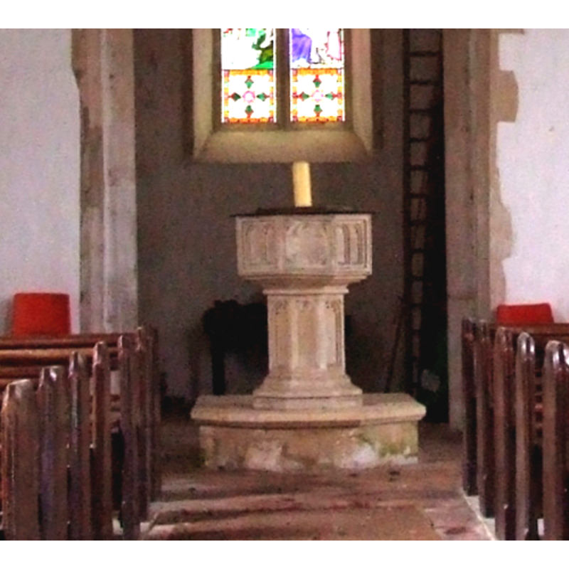
Image copyright © Simon Knott, 2008
Standing permission
Results: 8 records
design element - motifs - quatrefoil - in a circle
Scene Description: [cf. Font notes]
Copyright Statement: Image copyright © Simon Knott, 2008
Image Source: detail of a digital photograph taken 2 April 2008 by Simon Knott [http://www.norfolkchurches.co.uk/snetterton/snetterton.htm] [accessed 29 August 2009]
Copyright Instructions: Standing permission
design element - architectural - arch or window - trefoiled
Scene Description: [cf. Font notes]
Copyright Statement: Image copyright © Simon Knott, 2008
Image Source: detail of a digital photograph taken 2 April 2008 by Simon Knott [http://www.norfolkchurches.co.uk/snetterton/snetterton.htm] [accessed 29 August 2009]
Copyright Instructions: Standing permission
design element - motifs - moulding - graded
Copyright Statement: Image copyright © Simon Knott, 2008
Image Source: detail of a digital photograph taken 2 April 2008 by Simon Knott [http://www.norfolkchurches.co.uk/snetterton/snetterton.htm] [accessed 29 August 2009]
Copyright Instructions: Standing permission
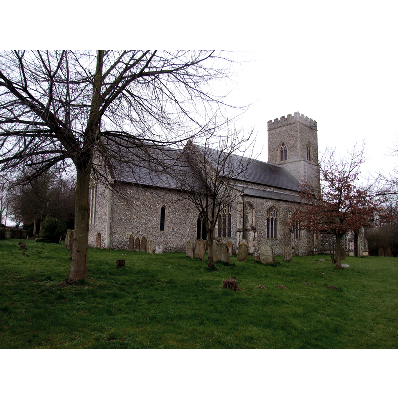
view of church exterior - northeast view
Copyright Statement: Image copyright © Simon Knott, 2008
Image Source: digital photograph taken 2 April 2008 by Simon Knott [www.norfolkchurches.co.uk/snetterton/snetterton.htm] [accessed 27 February 2013]
Copyright Instructions: Standing permission
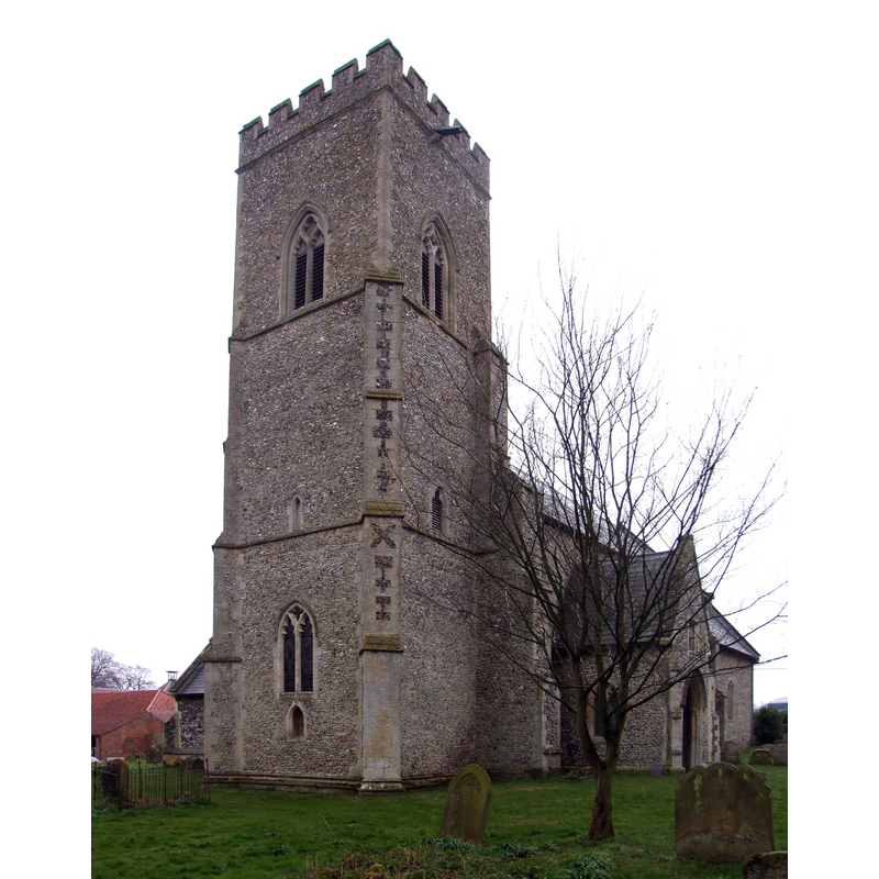
view of church exterior - southwest view
Copyright Statement: Image copyright © Simon Knott, 2008
Image Source: digital photograph taken 2 April 2008 by Simon Knott [www.norfolkchurches.co.uk/snetterton/snetterton.htm] [accessed 27 February 2013]
Copyright Instructions: Standing permission
view of church interior - nave - looking west
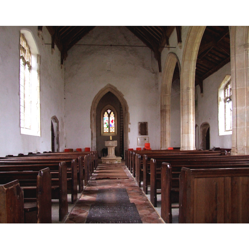
Scene Description: the font and cover at the west end, by the tower arch
Copyright Statement: Image copyright © Simon Knott, 2008
Image Source: digital photograph taken 2 April 2008 by Simon Knott [www.norfolkchurches.co.uk/snetterton/snetterton.htm] [accessed 29 August 2009]
Copyright Instructions: Standing permission
design element - architectural - arch or window - trefoiled - 8
Scene Description: [cf. Font notes]
Copyright Statement: Image copyright © Simon Knott, 2008
Image Source: detail of a digital photograph taken 2 April 2008 by Simon Knott [http://www.norfolkchurches.co.uk/snetterton/snetterton.htm] [accessed 29 August 2009]
Copyright Instructions: Standing permission
design element - motifs - moulding
Copyright Statement: Image copyright © Simon Knott, 2008
Image Source: detail of a digital photograph taken 2 April 2008 by Simon Knott [http://www.norfolkchurches.co.uk/snetterton/snetterton.htm] [accessed 29 August 2009]
Copyright Instructions: Standing permission
INFORMATION
Font ID: 15181SNE
Object Type: Baptismal Font1
Font Century and Period/Style: 14th century, Decorated
Church / Chapel Name: Parish Church of All Saints [redundant]
Font Location in Church: Inside the church, at the W end of the nave, by the tower arch
Church Patron Saint(s): All Saints
Church Address: Snetterton, Norfolk NR16 2LR
Site Location: Norfolk, East Anglia, England, United Kingdom
Directions to Site: Located 4 km N of East Harling, 6 km SW of Attleborough, between Harpham and Lerling
Ecclesiastic Region: Diocese of Norwich
Historical Region: Hundred of Shropham
Additional Comments: disappeared font(s)? (from the two 13thC (?) churches here)
Font Notes:
Click to view
Blomefield (1805-1810) writes: "Snetterton, in the Confessor's time, was two towns; the south part of it, with All-Saint's church, was known by the present name, but the north part, with St. Andrew's church thereto belonging, was then called Essebei, or Ashby, and continued that distinction at the Conqueror's survey, and some time after. [...] SNETRETUNA, SNISTERTUNA, SNISTERTON, or SNETTERTON, as it is now called, is a village lying between Harpham and Lerling, and had in it two parish churches, one dedicated to all the Saints, and the other to St. Andrew the Apostle, which is now down, and the ruins with difficulty found in the Hall-Yard. The Church of All-Saints, the present parish church, is a good building, having its nave, north isle, north porch, south porch, and chancel leaded, a square steeple, and four bells." Blomefield (ibid.) further notes that the first reported rector of All Saints was "Mr. Tho. de Ingaldesthorp", in 1257, while the first recorded rector of the disappeared St. Andrew's was "Sir William Le Parker", in 1257. The Domesday entries for both towns, Asby and Snetterton, are quoted in Blomefield (ibid.), but neither of them survey a church or a priest in them. There is no mention of a font in Blomefield's entry for Snetterton. A font in this church is noted in Pevsner & Wilson (1999): "Font. C14 bowl with encircled quatrefoils and tracery patterns." Illustrated in context in Knott (2008). The tracery appears to be pairs of arches on alternate sides with the quatrefoils; moulded underbowl; trefoiled arches or windows on the octagonal stem, moulded lower base also octagonal; on a polygonal plinth. The wooden cover is flat and plain, probably modern.
Credit and Acknowledgements: We are grateful to Simon Knott, of www.suffolkchurches.co.uk, for his photographs of this church and font.
COORDINATES
UTM: 31U 359785 5816534
Latitude & Longitude (Decimal): 52.480921, 0.935243
Latitude & Longitude (DMS): 52° 28′ 51.32″ N, 0° 56′ 6.88″ E
MEDIUM AND MEASUREMENTS
Material: stone
Font Shape: octagonal, mounted
Basin Interior Shape: round
Basin Exterior Shape: octagonal
LID INFORMATION
Apparatus: no
Notes: [cf. FontNotes]
REFERENCES
- Blomefield, Francis, An essay towards a topographical history of Norfolk, 1805-1810, vol. 1: 419-428 / [www.british-history.ac.uk/report.aspx?compid=77128] [accessed 27 February 2013]
- Knott, Simon, The Norfolk Churches Site, Simon Knott, 2004. [standing permission to reproduce images received from Simon (February 2005]. URL: www.norfolkchurches.co.uk.