Shouldham Thorpe / Carboisthorp / Shouldham Thorp
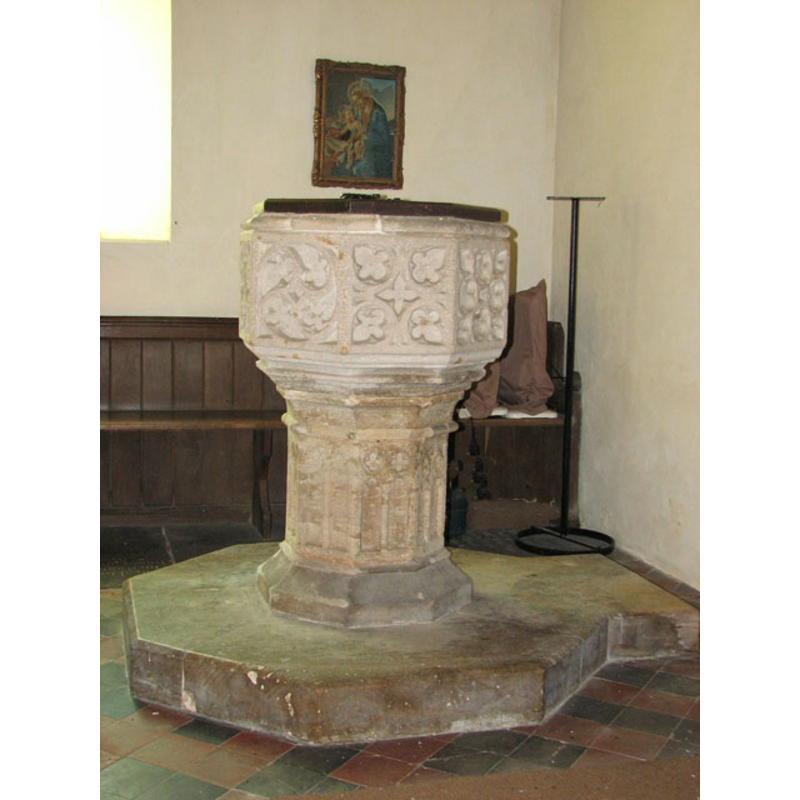
Image copyright © Evelyn Simak, 2010
CC-BY-SA-3.0
Results: 9 records
view of font and cover
Copyright Statement: Image copyright © Evelyn Simak, 2010
Image Source: digital photograph taken 6 May 2010 by Evelyn Simak [www.geograph.org.uk/photo/1846432] [accessed 27 August 2013]
Copyright Instructions: CC-BY-SA-3.0
design element - patterns - tracery
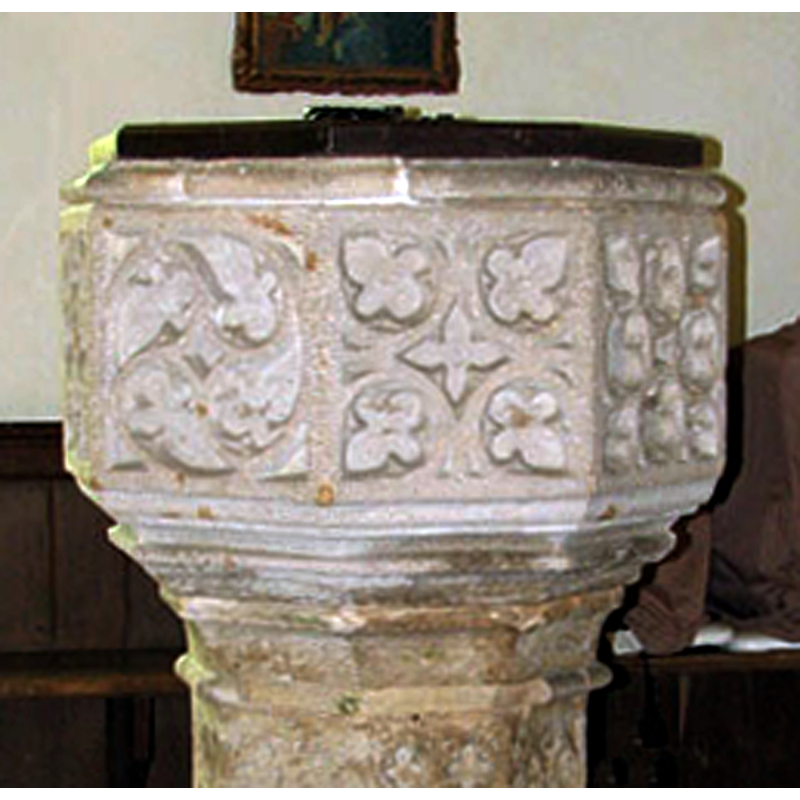
Copyright Statement: Image copyright © Evelyn Simak, 2010
Image Source: detail of a digital photograph taken 6 May 2010 by Evelyn Simak [www.geograph.org.uk/photo/1846432] [accessed 27 August 2013]
Copyright Instructions: CC-BY-SA-3.0
design element - motifs - moulding - graded
Copyright Statement: Image copyright © Evelyn Simak, 2010
Image Source: detail of a digital photograph taken 6 May 2010 by Evelyn Simak [www.geograph.org.uk/photo/1846432] [accessed 27 August 2013]
Copyright Instructions: CC-BY-SA-3.0
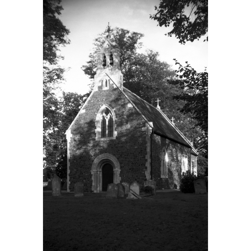
view of church exterior - southwest view
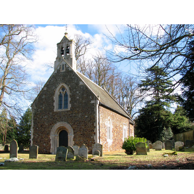
Copyright Statement: Image copyright © Evelyn Simak, 2010
Image Source: digital photograph taken 4 March 2010 by Evelyn Simak [www.geograph.org.uk/photo/1737716] [accessed 27 August 2013]
Copyright Instructions: CC-BY-SA-3.0
view of church exterior - west portal
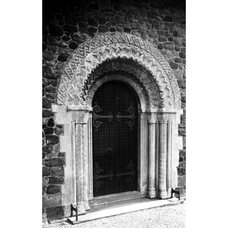
Scene Description: photo caption: "Almost rebuilt in 1852, but the Norman doorway, formerly in the north porch, was rebuilt at the west end"
Copyright Statement: Image copyright © George Plunkett, 2013
Image Source: B&W photograph taken 28 October 1995 by George Plunkett [www.georgeplunkett.co.uk/Norfolk/S/Shouldham Thorpe St Mary's Norman west door [5472] 1975-09-11.jpg] [accessed 27 August 2013]
Copyright Instructions: Standing permission by Jonathan Plunkett
view of church exterior - southwest view
Copyright Statement: Image copyright © George Plunkett, 2013
Image Source: B&W photograph taken 28 October 1995 by George Plunkett [www.georgeplunkett.co.uk/Norfolk/S/Shouldham Thorpe St Mary Virgin church SW [7287] 1995-10-28.jpg] [accessed 27 August 2013]
Copyright Instructions: Standing permission by Jonathan Plunkett
view of church interior - nave - looking west
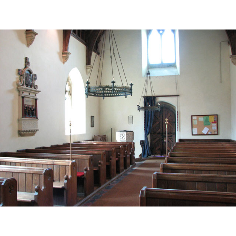
Copyright Statement: Image copyright © Evelyn Simak, 2010
Image Source: digital photograph taken 6 May 2010 by Evelyn Simak [www.geograph.org.uk/photo/1846430] [accessed 27 August 2013]
Copyright Instructions: CC-BY-SA-3.0
view of church interior - nave - looking east
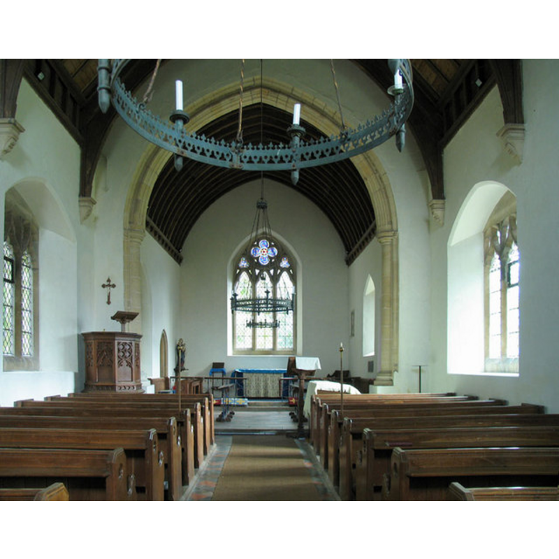
Copyright Statement: Image copyright © John Salmon, 2006
Image Source: digital photograph taken 3 September 2006 by John Salmon [www.geograph.org.uk/photo/321480] [accessed 27 August 2013]
Copyright Instructions: CC-BY-SA-3.0
design element - patterns - tracery
Copyright Statement: Image copyright © Evelyn Simak, 2010
Image Source: digital photograph taken 6 May 2010 by Evelyn Simak [www.geograph.org.uk/photo/1846432] [accessed 27 August 2013]
Copyright Instructions: CC-BY-SA-3.0
INFORMATION
Font ID: 15178SHO
Object Type: Baptismal Font1
Font Century and Period/Style: 15th century, Perpendicular
Church / Chapel Name: Parish Church of St. Mary the Virgin
Font Location in Church: Inside the church, at the W end of the nave, S side
Church Patron Saint(s): St. Mary the Virgin
Church Address: Church Lane, Shouldham Thorpe, Norfolk, PE33 0ED
Site Location: Norfolk, East Anglia, England, United Kingdom
Directions to Site: Located 8 km NE of Downham
Ecclesiastic Region: Diocese of Ely
Historical Region: Hundred and half of Clackclose
Additional Comments: disappeared font? (the one from the Domesday-time church here)
Font Notes:
Click to view
Blomefield (1805-1810) writes; "S[houldham] T[horp]. In the grand survey, or Domesday book, it is called Carboisthorp [...] Hermerus de Ferrariis (of whom see in Wermegay) had seized on 80 acres of land, and 5 of meadow, possessed by 11 freemen, and the moiety of another, with a bordarer and 3 carucates valued at 17s. and the moiety of the church endowed with 16 acres valued at 12d. [...] The Church is dedicated to the Virgin Mary, has a nave, and chancel covered with lead, the tower was at the west end, with three bells, and fell down in 1724". The present font is noted in Pevsner & Wilson (1999): "Font. Perp[endicular], octagonal, with a variety of tracery patterns." The font consists of an octagonal basin with vertical sides covered in different tracery paterns on each panel; moulding at the upper rim, showing several repairs; graded underbowl chamfer; window tracery on the sides of the octagonal pedestal base; splaying lower base, also octagonal; octagonal plinth with kneeling stone. The wooden cover is octagonal, flat and plain, with metal decoration and ring handle; perhaps Victorian. [NB: we have no information on the font from the original 11th-century (?) church here].
Credit and Acknowledgements: We are grateful to Jontahan Plunkett for the photographs of this church taken by his father, George Plunkett, in 1975 and 1995
COORDINATES
UTM: 31U 327735 5835777
Latitude & Longitude (Decimal): 52.644577, 0.453753
Latitude & Longitude (DMS): 52° 38′ 40.48″ N, 0° 27′ 13.51″ E
MEDIUM AND MEASUREMENTS
Material: stone
Font Shape: octagonal, mounted
Basin Interior Shape: round
Basin Exterior Shape: octagonal
LID INFORMATION
Date: modern?
Material: wood, oak?
Apparatus: no
Notes: [cf. FontNotes]
REFERENCES
- Blomefield, Francis, An essay towards a topographical history of Norfolk, 1805-1810, vol. 7: 427-430 / [www.british-history.ac.uk/report.aspx?compid=78375] [accessed 27 August 2013]
- Pevsner, Nikolaus, Norfolk 2: North-West and South (2nd ed.), London: Penguin, 1999, p. 652